The following images were all taken near the same location, ~37.9111404418945/122.731941223145:
Click on the small images to see the full-sized ones.
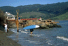
 A picnic lunch on the beach at Miller Point.
Taken on 1998-06-21 .
Links to related images: Date. Proofs. Map. Story.
 We go for a walk from Miller Point towards Alamere Falls.
Taken on 1998-06-21 .
Links to related images: Date. Proofs. Map. Story.

 Great lengths to avoid getting their feet wet aroud a point.
Taken on 1998-06-21 .
Links to related images: Date. Proofs. Map. Story.
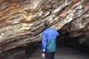
 Beautiful arch near Alamere Falls.
Taken on 1998-06-21 .
Links to related images: Date. Proofs. Map. Story.
 We go for a walk from Miller Point towards Alamere Falls.
Taken on 1998-06-21 .
Links to related images: Date. Proofs. Map. Story.
 Altamere Falls, and a group of friends hiking up the beach to see the
falls, the
Altamere Falls, and a group of friends hiking up the beach to see the
falls, the
Taken on 1998-06-21 .
Links to related images: Date. Proofs. Map. Story.
 Roger Lamb invenstigating the geology of Miller Point
Taken on 1998-03-8 .
Links to related images: Date. Proofs. Map. Story.
 Flowers on the cliff at Miller Point
Taken on 1998-03-8 .
Links to related images: Date. Proofs. Map. Story.
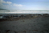
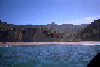
 start of Bolinas beach
Taken on 1998-02-14 .
Links to related images: Date. Proofs. Map. Story.
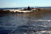
 View out over the white water
Taken on 1998-02-14 .
Links to related images: Date. Proofs. Map. Story.
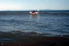
 surfer in front of waves with boat
Taken on 1998-02-14 .
Links to related images: Date. Proofs. Map. Story.
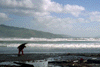
 surfer carrying boat up beach
Taken on 1998-02-14 .
Links to related images: Date. Proofs. Map. Story.
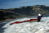
 Bill surfing X15
Taken on 1997-05-15 .
Links to related images: Date. Proofs. Map. Story.
 Bill launching
Taken on 1997-05-15 .
Links to related images: Date. Proofs. Map. Story.
 Wildcat Beach after a sucessful launch
Taken on 1996-06-17 .
Links to related images: Date. Proofs. Map. Story.
 Dead bird on WIldcat Beach
Taken on 1996-06-17 .
Links to related images: Date. Proofs. Map. Story.
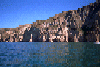
 Steep cliffs near Wildcat Beach
Taken on 1996-06-16 .
Links to related images: Date. Proofs. Map. Story.
 Approaching Wildcat Beach
Taken on 1996-06-16 .
Links to related images: Date. Proofs. Map. Story.
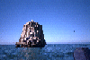
 Offshore rocks at Miller Point
Taken on 1996-06-16 .
Links to related images: Date. Proofs. Map. Story.
 Rocks off Miller Point
Taken on 1995-08-28 .
Links to related images: Date. Proofs. Map. Story.
 Rocks off Double Point, you can see Point Reyes in the distance
Taken on 1995-08-28 .
Links to related images: Date. Proofs. Map. Story.
 The Sculptured Coast
Taken on 1995-08-28 .
Links to related images: Date. Proofs. Map. Story.
 Approaching Double Point
Taken on 1995-08-28 .
Links to related images: Date. Proofs. Map. Story.
 Wildcat Beach in Point Reyes National Seashore
Taken on 1995-08-28 .
Links to related images: Date. Proofs. Map. Story.
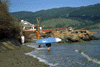
 Marty et all setting up camp at Wildcat Beach Campground
Taken on 1995-08-28 .
Links to related images: Date. Proofs. Map. Story.
 The shrine on the gravel beach north of Bolinas
Taken on 1995-08-27 .
Links to related images: Date. Proofs. Map. Story.
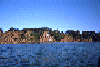
 The gravel beach north of Bolinas
Taken on 1995-08-27 .
Links to related images: Date. Proofs. Map. Story.

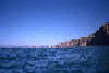
 Southern end of Point Reyes National Seashore
Taken on 1995-08-27 .
Links to related images: Date. Proofs. Map. Story.
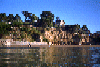
 Buildings above the bluff just south of Point Reyes National Seashore
Taken on 1995-08-27 .
Links to related images: Date. Proofs. Map. Story.
 Marty on Bolinas Beach
Taken on 1995-08-27 .
Links to related images: Date. Proofs. Map. Story.

 Stormy Stack, off Double Point, Point Reyes National Seashore
Taken on 1995-08-27 .
Links to related images: Date. Proofs. Map. Story.

 Double Point, Point Reyes National Seashore
Taken on 1995-08-27 .
Links to related images: Date. Proofs. Map. Story.
 Rock off Double Point, Point Reyes National Seashore
Taken on 1995-08-27 .
Links to related images: Date. Proofs. Map. Story.
 Stormy Stack off Double Point ahead of me.
Taken on 1995-08-27 .
Links to related images: Date. Proofs. Map. Story.

 Altamere Falls, and a group of friends hiking up the beach to see the
falls, the
Altamere Falls, and a group of friends hiking up the beach to see the
falls, the
Taken on 1995-08-27 .
Links to related images: Date. Proofs. Map. Story.
 of the salt marsh behind the beach.
Taken on ~1994 .
Links to related images: Date. Proofs. Map.
 The trail starts out along the sandy beach.
Taken on ~1994 .
Links to related images: Date. Proofs. Map.
 Then you follow the Coast Trail.
Taken on ~1994 .
Links to related images: Date. Proofs. Map.

 Views back to Point Reyes.
Taken on ~1994 .
Links to related images: Date. Proofs. Map.
 The last glimer of sunlight on the ridge above Wildcat.
Taken on ~1994 .
Links to related images: Date. Proofs. Map.
 Wildcat camp viewed from above as the sunlight fades.
Taken on ~1994 .
Links to related images: Date. Proofs. Map.
 Closer to Double Point, the lakes above Wildcat Camp can be seen.
Taken on ~1994 .
Links to related images: Date. Proofs. Map.
 These three pictures form a panoramic view from Double Point on the left
past t
These three pictures form a panoramic view from Double Point on the left
past t
Taken on ~1994 .
Links to related images: Date. Proofs. Map.
 of the salt marsh behind the beach.
Taken on ~1994 .
Links to related images: Date. Proofs. Map.

 These three pictures form a panoramic view from Double Point on the left
past t
These three pictures form a panoramic view from Double Point on the left
past t
Taken on ~1994 .
Links to related images: Date. Proofs. Map.
 A view forward to Double Point past Wildcat Camp.
Taken on ~1994 .
Links to related images: Date. Proofs. Map.
All text and images Copyright © by Mike Higgins / contact