Limantour Beach to Miller Point, March 8th 1998.
Click on the small image to see the full-sized one.
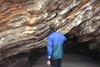
 Paul MacIntire entering the Secret Cave
Links to related images: Nearby. Proofs. Map.
Approximate location: 38.0075263977051N / 122.839614868164W.
 Roger Lamb invenstigating the geology of Miller Point
Links to related images: Nearby. Proofs. Map.
Approximate location: 37.9840888977051N / 122.806777954102W.
 Flowers on the cliff at Miller Point
Links to related images: Nearby. Proofs. Map.
Approximate location: 37.9850425720215N / 122.807945251465W.
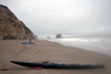 Kip and I landed in the Sculptured Beach area
Links to related images: Nearby. Proofs. Map.
Approximate location: 37.9938812255859N / 122.81884765625W.
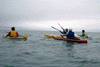 Joan leading kayakers away from nesting birds on Point Resistance
Links to related images: Nearby. Proofs. Map.
Approximate location: 37.9992408752441N / 122.830238342285W.
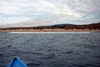 Launching from Limantour Beach
Links to related images: Nearby. Proofs. Map.
Approximate location: 38.0220642089844N / 122.880104064941W.
All text and images Copyright © 1998 by Mike Higgins / contact