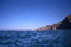
Wildcat Beach to Limantour Beach, August 28th 1995.
Click on the small image to see the full-sized one.
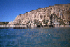
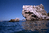
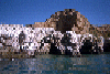
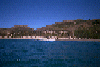 Landing at Limantour Beach, the last section of Marin County
Links to related images: Nearby. Proofs. Map.
Approximate location: 38.0221977233887N / 122.878433227539W.
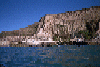
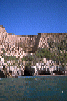
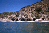
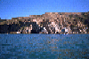
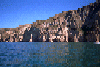
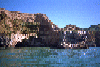
 The Scupltured Cliffs near Limantour Beach
Links to related images: Nearby. Proofs. Map.
Approximate location: 38.0088768005371N / 122.844398498535W.

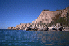
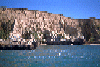
 The Scupltured Cliffs south of Miller Point
Links to related images: Nearby. Proofs. Map.
Approximate location: 38.0043296813965N / 122.835502624512W.
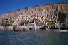
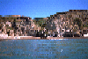
 Rocks off Point Resistance
Links to related images: Nearby. Proofs. Map.
Approximate location: 37.9983100891113N / 122.828857421875W.
 Just south of Point Resistance
Links to related images: Nearby. Proofs. Map.
Approximate location: 37.9980812072754N / 122.826728820801W.
 Miller Point
Links to related images: Nearby. Proofs. Map.
Approximate location: 37.9845771789551N / 122.812385559082W.
 Rocks off Miller Point
Links to related images: Nearby. Proofs. Map.
Approximate location: 37.9834632873535N / 122.809776306152W.
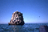
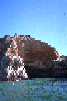
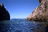
 Rocks off Double Point, you can see Point Reyes in the distance
Links to related images: Nearby. Proofs. Map.
Approximate location: 37.9463958740234N / 122.783027648926W.
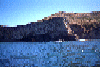
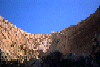
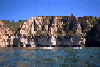
 The Sculptured Coast
Links to related images: Nearby. Proofs. Map.
Approximate location: 37.9393577575684N / 122.770668029785W.
 Approaching Double Point
Links to related images: Nearby. Proofs. Map.
Approximate location: 37.9341125488281N / 122.763031005859W.
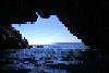
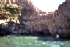
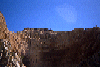 Up at the cathedral of Resistance Point from inside
Links to related images: Nearby. Proofs. Map.
Approximate location: 37.9984703063965N / 122.827629089355W.
 Looking into the center of Resistance Point
Links to related images: Nearby. Proofs. Map.
Approximate location: 37.9983367919922N / 122.828414916992W.
 This is one arch I didn't go through, if you look carfully you
will see a gro
This is one arch I didn't go through, if you look carfully you
will see a gro
Links to related images: Nearby. Proofs. Map.
Approximate location: 37.9978942871094N / 122.827842712402W.
 Looking into the center of Resistance Point
Links to related images: Nearby. Proofs. Map.
Approximate location: 37.9983863830566N / 122.827972412109W.
 Up at the cathedral of Resistance Point from inside
Links to related images: Nearby. Proofs. Map.
Approximate location: 37.9985198974609N / 122.827568054199W.
 Looking out between the south and north wing of Resistance Point
Links to related images: Nearby. Proofs. Map.
Approximate location: 37.9984893798828N / 122.827575683594W.
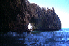
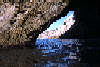 Looking out the big arch in the north wing of Resistance Point
Links to related images: Nearby. Proofs. Map.
Approximate location: 37.9985466003418N / 122.827537536621W.
 Looking out to sea from the inside of Resistance Point
Links to related images: Nearby. Proofs. Map.
Approximate location: 37.9985122680664N / 122.827514648438W.
 A second large arch in the south wing of Resistance Point
Links to related images: Nearby. Proofs. Map.
Approximate location: 37.9987335205078N / 122.827857971191W.
 Looking into one of the bigger arches that leads into Resistance Point
Links to related images: Nearby. Proofs. Map.
Approximate location: 37.998218536377N / 122.827491760254W.
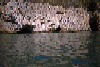
 Looking back through a small cave at Resistance Point
Links to related images: Nearby. Proofs. Map.
Approximate location: 37.9987487792969N / 122.826416015625W.
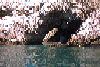
 A small cave that goes through Resistance Point
Links to related images: Nearby. Proofs. Map.
Approximate location: 37.9988327026367N / 122.825912475586W.
 Caves and arches just south of Resistance Point
Links to related images: Nearby. Proofs. Map.
Approximate location: 37.9981994628906N / 122.825057983398W.
 Approaching Resistance Point from the south
Links to related images: Nearby. Proofs. Map.
Approximate location: 37.9968566894531N / 122.823348999023W.
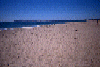
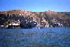
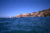
 Wildcat Beach in Point Reyes National Seashore
Links to related images: Nearby. Proofs. Map.
Approximate location: 37.9688987731934N / 122.792213439941W.
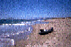
 Marty et all setting up camp at Wildcat Beach Campground
Links to related images: Nearby. Proofs. Map.
Approximate location: 37.9702606201172N / 122.790725708008W.
All text and images Copyright © 1995 by Mike Higgins / contact