The following images were all taken near the same location, ~39.0023994445801/120.250999450684:
Click on the small images to see the full-sized ones.
 The Spider Lake closed sign.
Taken on 2004-07-26 .
Links to related images: Date. Proofs. Map.
 Finally rolled the kayak back to Loon Lake.
Taken on 2004-07-26 .
Links to related images: Date. Proofs. Map.

 Back across Loon Lake to land near the Lodge.
Taken on 2004-07-26 .
Links to related images: Date. Proofs. Map.
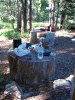 Buck Island Lake campground with 'tables'.
Taken on 2004-07-25 .
Links to related images: Date. Proofs. Map.
 Tent and kayak at Buck Island Lake campground.
Taken on 2004-07-25 .
Links to related images: Date. Proofs. Map.

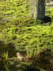
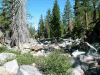
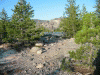
 Stream feading Rockbound Lake in the Desolation Wilderness.
Taken on 2004-07-25 .
Links to related images: Date. Proofs. Map.

 Lost in the Desolation Wilderness near Rubicon Resevoir.
Taken on 2004-07-25 .
Links to related images: Date. Proofs. Map.
 Looking down at Rockbound Lake.
Taken on 2004-07-25 .
Links to related images: Date. Proofs. Map.

 Finally found the Rubicon Resevoir again.
Taken on 2004-07-25 .
Links to related images: Date. Proofs. Map.


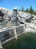
 The Rubicon Resevoir end of the tunnel to Rockbound Lake
Taken on 2004-07-25 .
Links to related images: Date. Proofs. Map.


 The Rubicon Resevoir end of the tunnel to Rockbound Lake.
Taken on 2004-07-25 .
Links to related images: Date. Proofs. Map.


 The Rockbound Lake end of the tunnel to Rubicon Resevoir.
Taken on 2004-07-25 .
Links to related images: Date. Proofs. Map.
 A panorama of Rockbound Lake.
Taken on 2004-07-25 .
Links to related images: Date. Proofs. Map.
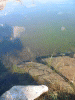
 The clear water off Buck Island.
Taken on 2004-07-24 .
Links to related images: Date. Proofs. Map.
 Moss growing on Buck Island.
Taken on 2004-07-24 .
Links to related images: Date. Proofs. Map.


 The Buck Island end of the tunnel to Loon Lake.
Taken on 2004-07-24 .
Links to related images: Date. Proofs. Map.
 Mergansers on Buck Island Lake.
Taken on 2004-07-24 .
Links to related images: Date. Proofs. Map.


 4WD trucks on the Rubicon Trail passing Buck Island Lake.
Taken on 2004-07-24 .
Links to related images: Date. Proofs. Map.
 A kayak on Buck Island Lake.
Taken on 2004-07-24 .
Links to related images: Date. Proofs. Map.
 Buck Island Lake viewed from above.
Taken on 2004-07-24 .
Links to related images: Date. Proofs. Map.
 First view of Rockbound Lake.
Taken on 2004-07-24 .
Links to related images: Date. Proofs. Map.
 First view of Rubicon Reservoir.
Taken on 2004-07-24 .
Links to related images: Date. Proofs. Map.
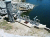
 Water side of the Rubicon Dam.
Taken on 2004-07-24 .
Links to related images: Date. Proofs. Map.

 Spillway side of the Rubicon Dam.
Taken on 2004-07-24 .
Links to related images: Date. Proofs. Map.

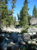
 Shortcut to the Rubicon River.
Taken on 2004-07-24 .
Links to related images: Date. Proofs. Map.

 Headwaters of the Rubicon River.
Taken on 2004-07-24 .
Links to related images: Date. Proofs. Map.
 Natual granite spillway near the eadwaters of the Rubicon River.
Taken on 2004-07-24 .
Links to related images: Date. Proofs. Map.


 Headwaters of the Rubicon River.
Taken on 2004-07-24 .
Links to related images: Date. Proofs. Map.


 The Rubicon River carves a narrow granite canyon.
Taken on 2004-07-24 .
Links to related images: Date. Proofs. Map.


 Then the Rubicon River Canyon starts to widen out.
Taken on 2004-07-24 .
Links to related images: Date. Proofs. Map.
 An occasonal slot carved by the Rubicon River in the granite.
Taken on 2004-07-24 .
Links to related images: Date. Proofs. Map.


 The Rubicon River widens into a meandering creek.
Taken on 2004-07-24 .
Links to related images: Date. Proofs. Map.
 The Rubicon River seeps through a wide meadow.
Taken on 2004-07-24 .
Links to related images: Date. Proofs. Map.

 This pile of boulders is actually the Rubicon 4WD Trail!
Taken on 2004-07-24 .
Links to related images: Date. Proofs. Map.
 The Rubicon 4WD Trail lead me back to Buck Island Lake.
Taken on 2004-07-24 .
Links to related images: Date. Proofs. Map.


 The spillway at Buck Island Lake.
Taken on 2004-07-24 .
Links to related images: Date. Proofs. Map.
 The Buck Island Lake end of the tunnel to Loon Lake.
Taken on 2004-07-24 .
Links to related images: Date. Proofs. Map.
 My kayak wating to take me back to camp on Buck Island.
Taken on 2004-07-24 .
Links to related images: Date. Proofs. Map.
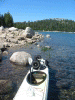
 Ready to launch on Loon Lake.
Taken on 2004-07-23 .
Links to related images: Date. Proofs. Map. Story.
 The kayak wheels on Loon Lake.
Taken on 2004-07-23 .
Links to related images: Date. Proofs. Map. Story.
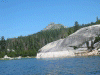
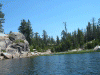 The granite shoreline of Loon Lake.
Taken on 2004-07-23 .
Links to related images: Date. Proofs. Map. Story.
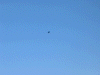 A bald eagle flies over Loon Lake.
Taken on 2004-07-23 .
Links to related images: Date. Proofs. Map. Story.
 The tunnel from Loon to Buck Island Lakes is under water here.
Taken on 2004-07-23 .
Links to related images: Date. Proofs. Map. Story.

 The granite shoreline of Loon Lake.
Taken on 2004-07-23 .
Links to related images: Date. Proofs. Map. Story.
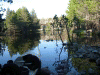
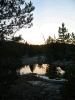
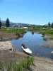 Laned in a lagoon off Loon Lake.
Taken on 2004-07-23 .
Links to related images: Date. Proofs. Map. Story.
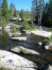
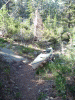
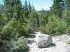 A typical boulder in the trail from Loon to Buck Island Lake.
Taken on 2004-07-23 .
Links to related images: Date. Proofs. Map. Story.

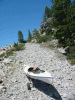 My kayak on the trail from Loon to Buck Island Lake.
Taken on 2004-07-23 .
Links to related images: Date. Proofs. Map. Story.
 Some welcome help on the trail to Buck Island Lake.
Taken on 2004-07-23 .
Links to related images: Date. Proofs. Map. Story.
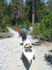
 A kayak has no business being on this trail in the Sierras.
Taken on 2004-07-23 .
Links to related images: Date. Proofs. Map. Story.
 Launching on Buck Island Lake at last.
Taken on 2004-07-23 .
Links to related images: Date. Proofs. Map. Story.
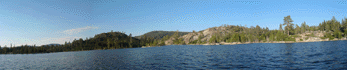 A panorama of the northeast shore of Buck Island Lake.
Taken on 2004-07-23 .
Links to related images: Date. Proofs. Map. Story.

 My campsite on Buck Island.
Taken on 2004-07-23 .
Links to related images: Date. Proofs. Map. Story.
All text and images Copyright © 2004 by Mike Higgins / contact