The following images were all taken near the same location, ~34.4088287353516/119.692398071289:
Click on the small images to see the full-sized ones.
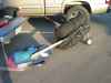 My kayak and gear transformed into a wheelbarrow to roll to my car
Taken on 2005-10-1 .
Links to related images: Date. Proofs. Map.


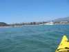
 Paddling out through the Santa Barbara harbort
Taken on 2005-09-20 .
Links to related images: Date. Proofs. Map. Story.


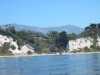
 Montecito and the rest of Santa Barbara County coastline is behind brick-brack
Taken on 2005-09-20 .
Links to related images: Date. Proofs. Map. Story.
 Private beach house
at Santa Barbara Point
Private beach house
at Santa Barbara Point
Taken on 2004-09-7 .
Links to related images: Date. Proofs. Map. Story.
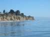 The last point of the trip
at Santa Barbara Point
The last point of the trip
at Santa Barbara Point
Taken on 2004-09-7 .
Links to related images: Date. Proofs. Map. Story.
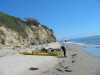 John and Fred on lunch break
at Santa Barbara Point
John and Fred on lunch break
at Santa Barbara Point
Taken on 2004-09-7 .
Links to related images: Date. Proofs. Map. Story.
 Birds
at Santa Barbara Point
Birds
at Santa Barbara Point
Taken on 2004-09-7 .
Links to related images: Date. Proofs. Map. Story.
 Fred and John packing up after lunch
at Santa Barbara Point
Fred and John packing up after lunch
at Santa Barbara Point
Taken on 2004-09-7 .
Links to related images: Date. Proofs. Map. Story.
 "Swim zone at Santa Barbara Harbor
Taken on 2004-09-7 .
Links to related images: Date. Proofs. Map. Story.

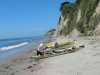
 The kayaks landed on the boatramp
at Santa Barbara Harbor
The kayaks landed on the boatramp
at Santa Barbara Harbor
Taken on 2004-09-7 .
Links to related images: Date. Proofs. Map. Story.
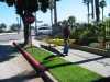 The intrepid kayaker rolling his kayak to a motel
at Santa Barbara Harbor
The intrepid kayaker rolling his kayak to a motel
at Santa Barbara Harbor
Taken on 2004-09-7 .
Links to related images: Date. Proofs. Map. Story.
All text and images Copyright © 2004 by Mike Higgins / contact