The following images were all taken near the same location, ~31.72448/116.72641:
Click on the small images to see the full-sized ones.

 Sea lion watching Gregg Berman off Isla Todos Santos
Taken on 2007-10-11 .
Links to related images: Date. Proofs. Map. Story.
 A tugboat crosses our path
Taken on 2007-10-11 .
Links to related images: Date. Proofs. Map. Story.
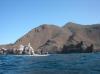
 Looking back to Isla Todos Santos behind Charles Harris
Taken on 2007-10-11 .
Links to related images: Date. Proofs. Map. Story.
 The light at Cabo Banda
Taken on 2007-10-11 .
Links to related images: Date. Proofs. Map. Story.
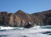
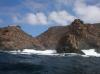
 The rough shoreline of Cabo Banda
Taken on 2007-10-11 .
Links to related images: Date. Proofs. Map. Story.
 Gregg Berman in front of the rough shoreline of Cabo Banda
Taken on 2007-10-11 .
Links to related images: Date. Proofs. Map. Story.
 The rough shoreline of Cabo Banda
Taken on 2007-10-11 .
Links to related images: Date. Proofs. Map. Story.
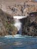
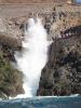 Gregg Berman in front of La Bufadora, the famous blow-hole
Taken on 2007-10-11 .
Links to related images: Date. Proofs. Map. Story.
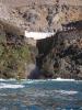
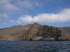
 The rough shoreline of Cabo Banda
Taken on 2007-10-11 .
Links to related images: Date. Proofs. Map. Story.
 The water calms down as we head south
Taken on 2007-10-11 .
Links to related images: Date. Proofs. Map. Story.
 Gregg Berman in a cave
Taken on 2007-10-11 .
Links to related images: Date. Proofs. Map. Story.
 The water calms down as we head south
Taken on 2007-10-11 .
Links to related images: Date. Proofs. Map. Story.
 Gregg Berman rock gardening around Isla Todos Santos
Taken on 2007-10-10 .
Links to related images: Date. Proofs. Map. Story.
 Gregg Berman in front of the aquaculture center on Isla Todos Santos
Taken on 2007-10-10 .
Links to related images: Date. Proofs. Map. Story.
 Sea lions on Isla Todos Santos
Taken on 2007-10-10 .
Links to related images: Date. Proofs. Map. Story.
 Aquaculture workers off Isla Todos Santos
Taken on 2007-10-10 .
Links to related images: Date. Proofs. Map. Story.


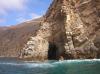
 Our first paddle-in cave on Isla Todos Santos
Taken on 2007-10-10 .
Links to related images: Date. Proofs. Map. Story.
 Greggs yellow boat viewed through a crack into another cave
Taken on 2007-10-10 .
Links to related images: Date. Proofs. Map. Story.
 Gregg Berman exiting a cave on Isla Todos Santos
Taken on 2007-10-10 .
Links to related images: Date. Proofs. Map. Story.
 Approaching the south end of Isla Todos Santos
Taken on 2007-10-10 .
Links to related images: Date. Proofs. Map. Story.

 Gregg Berman near the south end of Isla Todos Santos
Taken on 2007-10-10 .
Links to related images: Date. Proofs. Map. Story.

 A beach near the south end of Isla Todos Santos
Taken on 2007-10-10 .
Links to related images: Date. Proofs. Map. Story.


 Gregg Berman going over a washover at Isla Todos Santos
Taken on 2007-10-10 .
Links to related images: Date. Proofs. Map. Story.
 Gregg Berman near the south end of Isla Todos Santos
Taken on 2007-10-10 .
Links to related images: Date. Proofs. Map. Story.
 The light at the south end of Isla Todos Santos
Taken on 2007-10-10 .
Links to related images: Date. Proofs. Map. Story.
 Gregg Berman near the south end of Isla Todos Santos
Taken on 2007-10-10 .
Links to related images: Date. Proofs. Map. Story.

 Approaching the south end of Isla Todos Santos
Taken on 2007-10-10 .
Links to related images: Date. Proofs. Map. Story.


 Gregg Berman in rough water off Isla Todos Santos
Taken on 2007-10-10 .
Links to related images: Date. Proofs. Map. Story.
 The lighthouse on Isla Todos Santos Norte
Taken on 2007-10-10 .
Links to related images: Date. Proofs. Map. Story.


 Gregg Berman in rough water off Isla Todos Santos
Taken on 2007-10-10 .
Links to related images: Date. Proofs. Map. Story.
 Gregg Berman in the channel between Isla Todos Santos Norte and Sur
Taken on 2007-10-10 .
Links to related images: Date. Proofs. Map. Story.
 Gregg Berman writing in his journal on Isla Todos Santos
Taken on 2007-10-10 .
Links to related images: Date. Proofs. Map. Story.
 Rocky crag on Isla Todos Santos
Taken on 2007-10-10 .
Links to related images: Date. Proofs. Map. Story.


 Views from the top of Isla Todos Santos
Taken on 2007-10-10 .
Links to related images: Date. Proofs. Map. Story.
 Charles Harris on top of Isla Todos Santos
Taken on 2007-10-10 .
Links to related images: Date. Proofs. Map. Story.

 The intrepid kayaker on top of Isla Todos Santos (does this shirt make me look fat?)
Taken on 2007-10-10 .
Links to related images: Date. Proofs. Map. Story.


 Views from the top of Isla Todos Santos
Taken on 2007-10-10 .
Links to related images: Date. Proofs. Map. Story.
 Our campsite area viewed from the top of Isla Todos Santos
Taken on 2007-10-10 .
Links to related images: Date. Proofs. Map. Story.

 Views from the top of Isla Todos Santos
Taken on 2007-10-10 .
Links to related images: Date. Proofs. Map. Story.
 The aquaculture center viewed from the top of Isla Todos Santos
Taken on 2007-10-10 .
Links to related images: Date. Proofs. Map. Story.


 Charles Harris walking back down from the top of Isla Todos Santos
Taken on 2007-10-10 .
Links to related images: Date. Proofs. Map. Story.
 Charles Harris and Gregg Berman cooking dinner on Isla Todos Santos
Taken on 2007-10-10 .
Links to related images: Date. Proofs. Map. Story.
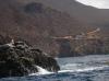
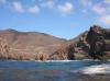
 Rocky shore of Isla Todos Santos, Baja
Taken on 2007-10-9 .
Links to related images: Date. Proofs. Map. Story.
 The harbor seals of Isla Todos Santos do not spook off the rocks
Taken on 2007-10-9 .
Links to related images: Date. Proofs. Map. Story.
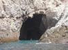
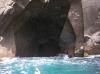
 A cave in Isla Todos Santos
Taken on 2007-10-9 .
Links to related images: Date. Proofs. Map. Story.
 Aquaculture float ring close to Isla Todos Santos
Taken on 2007-10-9 .
Links to related images: Date. Proofs. Map. Story.

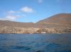
 Aquaculture headquarters on Isla Todos Santos
Taken on 2007-10-9 .
Links to related images: Date. Proofs. Map. Story.
All text and images Copyright © 2007 by Mike Higgins / contact