Layover day on Isla Todos Santos, October 10th 2007.
Click on the small image to see the full-sized one.
 A bedraggled pelican shared our campsite for a night
Links to related images: Nearby. Proofs. Map.
Approximate location: 31.8054N / 116.78909W.

 Our campsite on Isla Todos Santos viewed through the dry arch
Links to related images: Nearby. Proofs. Map.
Approximate location: 31.80542N / 116.78909W.
 Our campsite on Isla Todos Santos
Links to related images: Nearby. Proofs. Map.
Approximate location: 31.80551N / 116.78806W.
 Gregg Berman rock gardening around Isla Todos Santos
Links to related images: Nearby. Proofs. Map.
Approximate location: 31.80355N / 116.78823W.
 Gregg Berman in front of the aquaculture center on Isla Todos Santos
Links to related images: Nearby. Proofs. Map.
Approximate location: 31.80027N / 116.78662W.
 Sea lions on Isla Todos Santos
Links to related images: Nearby. Proofs. Map.
Approximate location: 31.79928N / 116.7863W.
 Aquaculture workers off Isla Todos Santos
Links to related images: Nearby. Proofs. Map.
Approximate location: 31.79812N / 116.78684W.


 Our first paddle-in cave on Isla Todos Santos
Links to related images: Nearby. Proofs. Map.
Approximate location: 31.79579N / 116.78688W.
 Greggs yellow boat viewed through a crack into another cave
Links to related images: Nearby. Proofs. Map.
Approximate location: 31.79579N / 116.78688W.
 Gregg Berman exiting a cave on Isla Todos Santos
Links to related images: Nearby. Proofs. Map.
Approximate location: 31.79797N / 116.78658W.
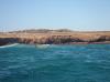
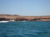
 Approaching the south end of Isla Todos Santos
Links to related images: Nearby. Proofs. Map.
Approximate location: 31.79699N / 116.78692W.

 Gregg Berman near the south end of Isla Todos Santos
Links to related images: Nearby. Proofs. Map.
Approximate location: 31.79448N / 116.78724W.

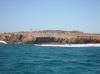
 A beach near the south end of Isla Todos Santos
Links to related images: Nearby. Proofs. Map.
Approximate location: 31.7933N / 116.78722W.


 Gregg Berman going over a washover at Isla Todos Santos
Links to related images: Nearby. Proofs. Map.
Approximate location: 31.7936N / 116.78722W.
 Gregg Berman near the south end of Isla Todos Santos
Links to related images: Nearby. Proofs. Map.
Approximate location: 31.79111N / 116.78666W.
 The light at the south end of Isla Todos Santos
Links to related images: Nearby. Proofs. Map.
Approximate location: 31.79109N / 116.78675W.
 Gregg Berman near the south end of Isla Todos Santos
Links to related images: Nearby. Proofs. Map.
Approximate location: 31.79094N / 116.78686W.

 Approaching the south end of Isla Todos Santos
Links to related images: Nearby. Proofs. Map.
Approximate location: 31.79156N / 116.78872W.


 Gregg Berman in rough water off Isla Todos Santos
Links to related images: Nearby. Proofs. Map.
Approximate location: 31.79634N / 116.79235W.
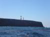
 The lighthouse on Isla Todos Santos Norte
Links to related images: Nearby. Proofs. Map.
Approximate location: 31.79634N / 116.79235W.


 Gregg Berman in rough water off Isla Todos Santos
Links to related images: Nearby. Proofs. Map.
Approximate location: 31.80109N / 116.79608W.
 Gregg Berman in the channel between Isla Todos Santos Norte and Sur
Links to related images: Nearby. Proofs. Map.
Approximate location: 31.80372N / 116.79917W.
 The landing beach on Isla Todos Santos Norte
Links to related images: Nearby. Proofs. Map.
Approximate location: 31.80887N / 116.79992W.
 Gregg Berman rounding the east side of Isla Todos Santos Norte
Links to related images: Nearby. Proofs. Map.
Approximate location: 31.80887N / 116.79992W.
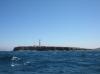
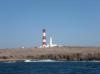
 The lighthouse on Isla Todos Santos Norte
Links to related images: Nearby.
Approximate location: 31.81505N / 116.80357W.
 Gregg Berman in front of the lighthouse on Isla Todos Santos Norte
Links to related images: Nearby.
Approximate location: 31.8149N / 116.80958W.
 The lighthouse on Isla Todos Santos Norte
Links to related images: Nearby.
Approximate location: 31.80988N / 116.81239W.
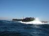
 Gregg Berman in rough water on the north end of Isla Todos Santos
Links to related images: Nearby.
Approximate location: 31.80982N / 116.81235W.
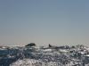
 Sea lions on a rock off Isla Todos Santos
Links to related images: Nearby.
Approximate location: 31.80909N / 116.81153W.
 The lighthouse on Isla Todos Santos Norte
Links to related images: Nearby.
Approximate location: 31.80703N / 116.80748W.

 Gregg Berman catches some kayak surfing rides
Links to related images: Nearby.
Approximate location: 31.8054N / 116.8002W.
 Gregg Berman off Isla Todos Santos
Links to related images: Nearby. Proofs. Map.
Approximate location: 31.80767N / 116.79385W.
 Gregg Berman writing in his journal on Isla Todos Santos
Links to related images: Nearby. Proofs. Map.
Approximate location: 31.80242N / 116.79046W.
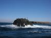
 Rocky crag on Isla Todos Santos
Links to related images: Nearby. Proofs. Map.
Approximate location: 31.80237N / 116.79059W.


 Views from the top of Isla Todos Santos
Links to related images: Nearby. Proofs. Map.
Approximate location: 31.80066N / 116.79153W.
 Charles Harris on top of Isla Todos Santos
Links to related images: Nearby. Proofs. Map.
Approximate location: 31.79937N / 116.78922W.

 The intrepid kayaker on top of Isla Todos Santos (does this shirt make me look fat?)
Links to related images: Nearby. Proofs. Map.
Approximate location: 31.79937N / 116.78924W.


 Views from the top of Isla Todos Santos
Links to related images: Nearby. Proofs. Map.
Approximate location: 31.79918N / 116.78928W.
 Our campsite area viewed from the top of Isla Todos Santos
Links to related images: Nearby. Proofs. Map.
Approximate location: 31.79918N / 116.78928W.

 Views from the top of Isla Todos Santos
Links to related images: Nearby. Proofs. Map.
Approximate location: 31.79918N / 116.78943W.
 The aquaculture center viewed from the top of Isla Todos Santos
Links to related images: Nearby. Proofs. Map.
Approximate location: 31.79999N / 116.78883W.


 Charles Harris walking back down from the top of Isla Todos Santos
Links to related images: Nearby. Proofs. Map.
Approximate location: 31.80074N / 116.79128W.
 Charles Harris and Gregg Berman cooking dinner on Isla Todos Santos
Links to related images: Nearby. Proofs. Map.
Approximate location: 31.80338N / 116.78935W.
All text and images Copyright © 2007 by Mike Higgins / contact