The following images were all taken near the same location, ~31.71285/116.70671:
Click on the small images to see the full-sized ones.
 A tugboat crosses our path
Taken on 2007-10-11 .
Links to related images: Date. Proofs. Map. Story.
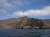
 Looking back to Isla Todos Santos behind Charles Harris
Taken on 2007-10-11 .
Links to related images: Date. Proofs. Map. Story.
 The light at Cabo Banda
Taken on 2007-10-11 .
Links to related images: Date. Proofs. Map. Story.
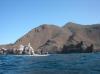
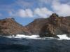
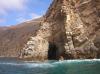
 The rough shoreline of Cabo Banda
Taken on 2007-10-11 .
Links to related images: Date. Proofs. Map. Story.
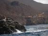
 Gregg Berman in front of the rough shoreline of Cabo Banda
Taken on 2007-10-11 .
Links to related images: Date. Proofs. Map. Story.
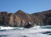
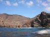
 The rough shoreline of Cabo Banda
Taken on 2007-10-11 .
Links to related images: Date. Proofs. Map. Story.
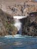
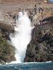 Gregg Berman in front of La Bufadora, the famous blow-hole
Taken on 2007-10-11 .
Links to related images: Date. Proofs. Map. Story.
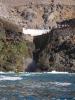
 The rough shoreline of Cabo Banda
Taken on 2007-10-11 .
Links to related images: Date. Proofs. Map. Story.
 The water calms down as we head south
Taken on 2007-10-11 .
Links to related images: Date. Proofs. Map. Story.
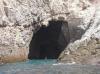
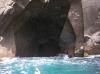
 Gregg Berman in a cave
Taken on 2007-10-11 .
Links to related images: Date. Proofs. Map. Story.
 The water calms down as we head south
Taken on 2007-10-11 .
Links to related images: Date. Proofs. Map. Story.
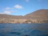
 Gregg Berman near the south end of Isla Todos Santos
Taken on 2007-10-10 .
Links to related images: Date. Proofs. Map. Story.
All text and images Copyright © 2007 by Mike Higgins / contact