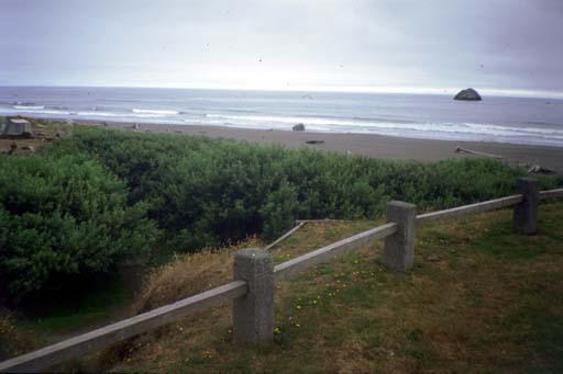
After looking at the ocean beaches from both sides and trying out the smith river, I decided to camp a mile north of the Smith River where I could launch from the ocean for this leg of the trip. I paid for two nights so I could leave my car there an extra night if I could not get back Tuesday evening. There is no public transit this far north so I had a three tiered plan. 1) I would try to take a cab the 30 kilometers back to my car if they were willing to go that far and if it didn't cost an arm and a leg. I tried calling Del Note Cab Service a few times but they never answered the phone. (I'm told that they have only one car). 2) If a cab failed me I would try to hitch-hike back to my car but I hate hitch-hiking and don't have a lot of faith in it. 3) I would camp the night in Crescent City and paddle my kayak back to my car the next day.
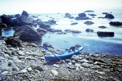
I got up at 7:00 AM but had to pack my camping gear in the kayak so it took almost two hours to get ready. I have a small buivy tent and a small thinsulate sleeping bag, so most of my camping gear fits in one drybag. Another bag holds the thermarest and some rain gear. Another held my stove, two breakfasts and one dinner. Two lunches went in a smaller bag up front where I could get to it easily. A final bag held my folded up wheels so I could move the boat around downtown Crescent city if I had to. Then there was the first aid kit, spare paddles, bilge pump, sponge, my usual emergency kit with flashlight, toilet paper, pack towel, etc. The Scupper Pro kayak was not half full, so I left the float bags partially inflated to hold everything in place.
I launched into mild surf on a three foot swell day. My timing was bad, but my surf launch practice paid off. I sat behind the impact zone and waited out a big set. I got slammed in the face a few times with salt water but kept the boat in place until a window opened and I paddled out.
I turned left and headed towards Hunter Rock and Prince Island. Yesterday I had timed myself from Smith River to the campground and expected it to add 30 minutes to my trip. I was pleasantly surprised to pass the river early and by the time an hour had passed, the rocks were well behind me and I figured I was half way down the long sandy beach of Pelican Bay. I recalled the time I paddled almost 50 kilometers in one day in San Francisco Bay and started thinking I could stop for lunch at Crescent City and keep going to Youth Hostel Today. However "Half way down the beach" was an illusion and new stretches of beach kept appearing out of the fog ahead of me.
This long stretch of beach made my morale droop and firmed my resolve to find a ride back to my car. I didn't want to do this beach twice. Then the wind started up. The usual weather pattern in northern California is wind and waves from the northwest, so I planned this trip from north to south in case it was windy. But this wind was from the south! I had no choice but to plow my kayak into the wind and the waves it fetched up. The wind never exceeded 8 or 10 knots, in my estimation, but it made the afternoon a lot less fun than it could have been.
As I paddled down this long (17 km) beach I started thinking that this was similar to the beach where I saw a shark from my kayak. Shortly after this thought, a dolphin popped up to the surface ten meters ahead of me. He was moving fast and I just had time to hear him exhale/inhale, then he was gone. For the rest of the day I spotted a dolphin from time to time. Over the sound of the wind and waves I never heard one breath again, so more of them probably appeared that I didn't see or hear. This makes me think there must be a lot of them out here that people never notice.
I followed a row of crab buoys along the coast, wondering what they were doing out here after the end of crab season. Do they abandon the traps for the off season? I got used to having crab buoys go by to measure my progress against, so when they stopped for a while I missed them!. Whenever I rested I always stopped near one of these so I could tell how fast the wind pushed me back. One of these time I stopped to try peeing on the high seas. One of our Astronauts says that the most common question that children asked him was how he went to the bathroom in zero gravity, so in the book "A House in Space" (about the Skylab project) he wrote a whole chapter on the subject. Some wetsuits have a "relief zipper" in the crotch. I usually prefer to land to take care of business, but didn't want to launch on this dumpy beach. On land I can roll the wetsuit down far enough and stretch the front of my dive-skin down far enough to pee but I've never tried this at sea until now. I found that I had to sit high up above the seat to get my legs close enough together for the wetsuit to roll almost far enough down. This made the boat tippy so my knees hooked the gunwale and my calves held onto the bottom of the boat for balance. Locked in this position I could only pee into the seat and foot wells, which were full of sea water anyway. When done I rocked the boat to slosh more seawater in and wash it down the scupper holes.
As I approached Point Saint George I started seeing the crab buoys again. I was tired and worried about going through the rocks around the point. But if I stopped to eat lunch the wind would blow me way back. So I did something I have heard is a violation of the Rules Of The Sea. I tied up to a crab buoy while I ate lunch and rested.
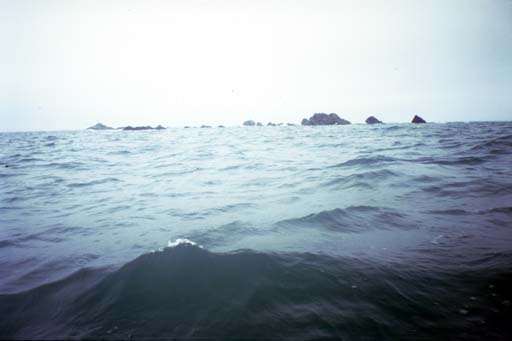
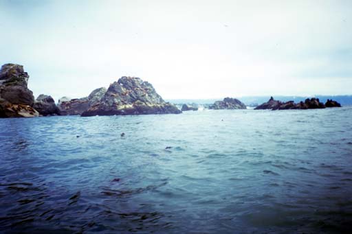
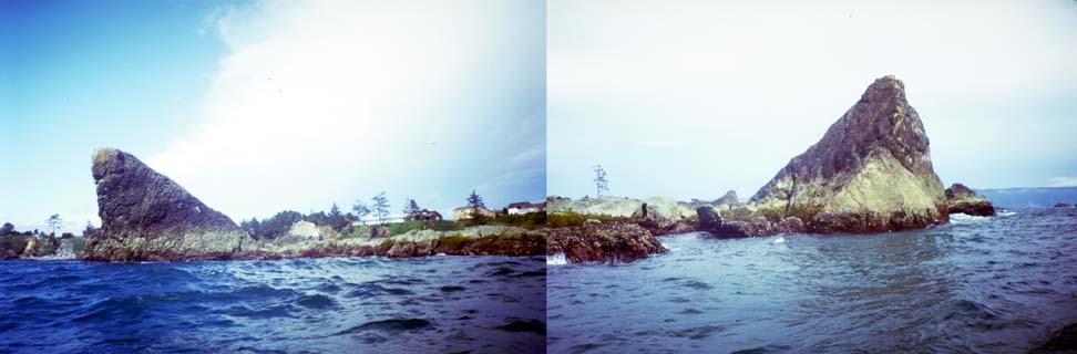
When I finally made it to Point Saint George, I started wishing I had stopped and talked to some locals about this rocky area. I considered following the reef out looking for a calm way around, but I wanted to make more direct progress against the wind. The Saint George Reef extends 12 kilometers northwest from shore! Between the point of the shore and the first rocks I saw some strange water behavior. Waves wrapping around the reef and meeting themselves at this spot. The behavior didn't extend all the way to shore so I turned closer to the point to avoid it. On the other side of the point I could see waves breaking a long distance to the cliff, but figured I could turn out around this after passing over the shallow reef. This turned out to be correct and I found myself inside an extensive rock garden in choppy water.
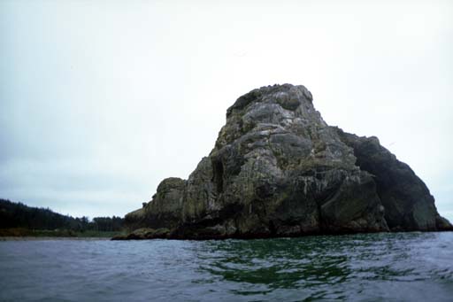
I worked my way towards Castle Rock, which I had seen sticking up over the low point all day. Catching sight of the harbor lighthouse I turned to go through a closely spaced cluster of rocks. These rocks were covered with barking sea lions. This had me worrying about sharks again. Outside the cluster I paddled behind a row of large rocks that had no name on the chart. I guess Crescent City waters has so many they stopped naming them, or even putting more mention on the chart than an asterisk for the location of each one.
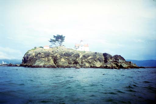
I was conserving the last few pictures in my camera for the lighthouse ahead and decided this was stupid. I worked my way through a rock strewn shore to a calm beach and landed for a rest and to re-load the camera. Once close to shore I stayed between the small rocks as I worked my way around the remains of Preston Island. This used to be a large rock just offshore but it was quarried down to the waterline to construct parts of the jetties for the harbor. For some reason they left two large pointy corners of the rock in place and from my perspective it looked like the lower jaw and fangs of a sea lion.
I tried to head directly towards the lighthouse through the rock garden, but I spied a cluster of white blobs on the rocks ahead. Through my binoculars I verified that the blobs were harbor seals. There is a group of environmentalists who claim that kayaks should be banned from many places because kayakers disturb wildlife. Harbor seals are particularly sensitive to kayaks. They don't seem to be as scared of motor boats! My favorite hypothesis to explain this is that they have an oral tradition passed down through the generations of being hunted by kayak. Other people say it is the paddles waving in the air that bothers them. Whatever the reason, I turned and gave them a wide berth. The anti-kayak people think that we want to get too close to seals to observe them. They say we should use binoculars and watch them from a distance. I don't want to see the seals up close, I just want to paddle through the rock gardens that the seals are sleeping in. If the seals would just learn to put up with kayaks close to them we could all be happy.
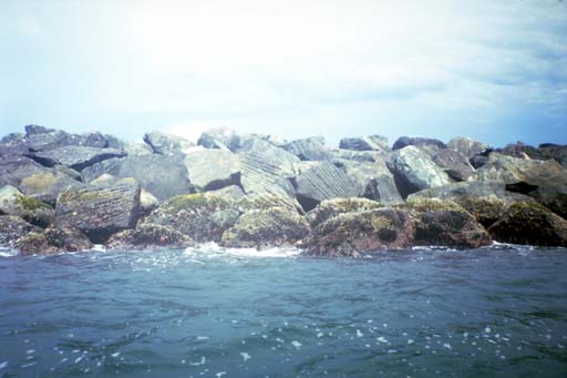
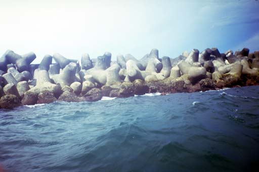
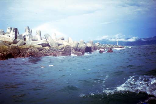
I paddled around the Crescent City Lighthouse taking a bunch of pictures, none of which turned out well. My chart shows water between the land and the rock that the lighthouse was built on, but now there is a walkway so people can go on tours. There were packed sandy beaches here where I could have landed and crossed over into the harbor. Instead I chose to fight my way into the wind and paddle around the end of the jetty into the harbor. The jetty is made of natural rock (quarried from Preston Island) and two kinds of artificial breakwater rocks, tetras and double anchors. I wanted to get pictures of these in use. When engineers started running out of places to quarry and tear apart to make breakwaters and jetties, they started making "rocks" out of concrete. But despite calculations about the strength and salt resistance of concrete, breakwaters made out of concrete rocks never lasted as long as breakwaters made out of natural rock. Some French engineers figured out why: Naturally quarried rock has irregular shapes while the concrete "rocks" were usually made in cubes because that was easiest. The "unnatural" cube shapes slide against each other too easily and the breakwater slips apart. Natural stones catch on each other and hang together. So these French engineers designed a concrete rock, called a Tetra, that has four conical ends sort of like a four sided toy jack. When piled up in a breakwater these lock into each other and hang together even longer than natural rocks. Crescent City was the first harbor to try these out, so they have one mounted on display on the side of Highway 101 as you drive into the city from the south. Since then someone came up with yet another design that looks like a double-ended anchor. When part of the Crescent City Harbor needed repairs, they tried some of these in that section. I forced myself to paddle into the wind on the end of a long day so I could take pictures of these artificial rocks as I paddled past. Unfortunately the wind fetched up waves that splashed over my bow and rained drops on my unprotected camera. As I worked my way around the jetty I could tell that the lens of the camera was getting more and more fogged up and I fear that the pictures will not turn out very well.
Once I made it around the end of the jetty I turned away from the wind and let it help me paddle across the harbor towards the campground I had picked out for the evening. I discovered that I was landing at low tide and had to drag my boat a long way to get to the corner of the campground. I met a guy who had his camper parked there who was very helpful. He let me use his hose to rinse off my equipment, and then offered me a ride back to my car! I think this is the trick to hitch-hiking on a kayaking trip. Strike up a conversation with the people who see you land and find someone who is interested enough to help you out. Random strangers driving by you on the side of the road are never as likely to help.
I landed around 5:00 PM and wondered how it could have taken me so long to paddle the distance from Smith River to Crescent City. I checked my maps later and found that I had seriously underestimated the distance. Especially when you count the distance around the jetty, this was a 32 kilometer paddle, and not the 22 kilometer paddle I had expected!