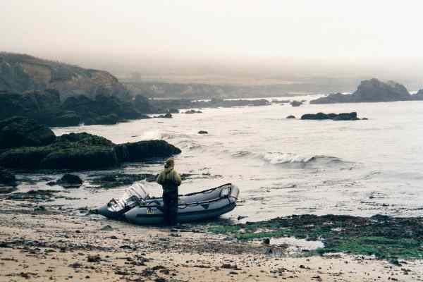
While I was doing some final packing a Zodiac with two orange jacketed people on it made a pass, then turned in to land on the beach. I figured they were Coast Guard here to tell me to get off the beach or to tell me to stay off the water, or to tell me some other self contradictory regulations to obey. Instead they turned out to be locals who were landing for the day because conditions were getting too rough. When I told them what I was doing, they did advise me to stay off the water. Their main concern was the wind, predicted to get to 20 knots. They also said that the area between here and Davenport Landing (my next stop) often had worse than predicted winds.
I launched anyway into fog, mild swell, and a mild wind at my back ("Don't be fooled by mild conditions here behind the point"). I never saw whitecaps all day and believe it never exceeded 12 knots, although the swell exceeded all predictions on this day. I told my local friends as I left that I would be off the water by 1:00 PM before the worst of the wind could come up.
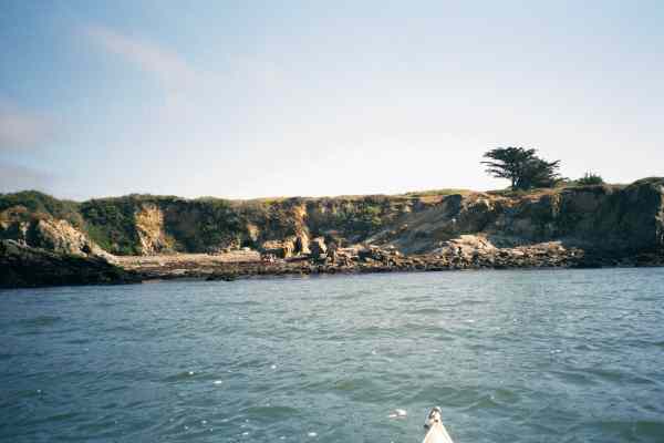
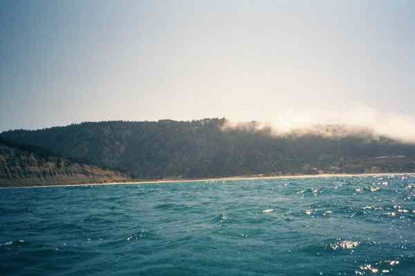
The day before I had seen Año Nuevo Island from the lighthouse. This morning it was lost in the fog. To quicken my day I did not hug the shore but paddled across to Franklin Point. One there I reveled in the waves rising around the point and turned behind it to do some rock gardening. I rode into a little cove where a landing was recommended to me, just to check it out. It looked like landing was easy, but camping would require carrying gear up to a low bluff to get above the high tide.
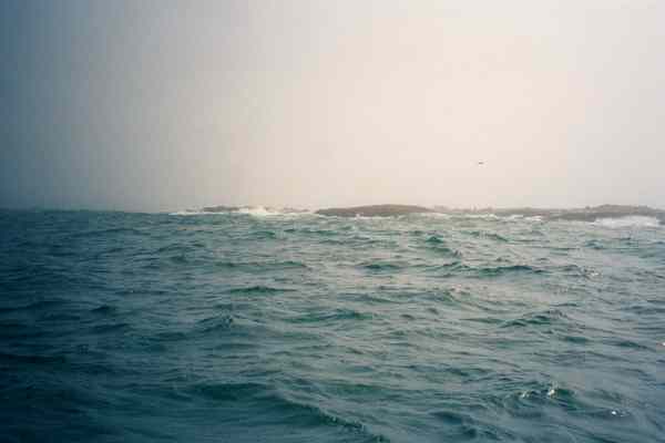
Back out of the cove I turned straight towards Año Nuevo Island, or at least where I thought it should be in the fog. The fog alternated between thick, where I could see the shore to my left but not the island ahead, and thicker where I could see nothing but the water around me and a faded image of the sun above. I navigated by the angle of the sun, the angle of the waves and the sound of the sea lions barking on the island. I worried that the wind might play tricks with me making the sound come from the wrong angle.
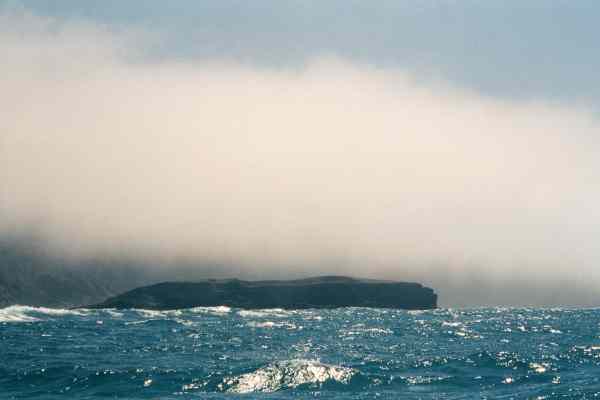
The day before I had debated going between the island and the mainland but this former isthmus is exposed at low tide and presumably only navigable at high tide. I would be passing the island only two hours after low tide. Some of the swells were quite high, perhaps 8 feet, and I didnt want to find out the hard way if I could surf an eight foot wave in only two feet of water! So I wanted to go around the outside of the island.
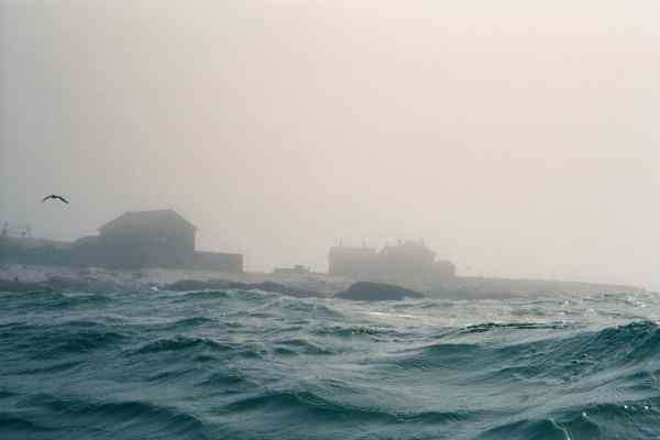
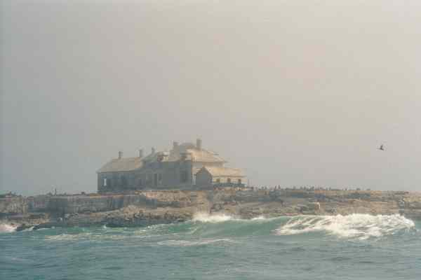
Finally I saw the island through the fog and adjusted my course to go around. At first I could only see the outer rocks, then the black outlines of the abandoned houses on the island. A faded sunlight fell on the island but since I was still in fog the houses and collapsed radio tower were bright but still indistinct. I could see hundreds of seals on the island.
As I passed outside the island I heard a motor and when I came out past the island I saw a Zodiac heading for shore. Perhaps a researcher returning from observations or a ranger returning from looking for miscreant kayakers. Ken Kelton, who loves paddling this area despite having his kayak bitten by a great white shark, was once threatened by a park ranger who didn't like kayakers near his island. The ranger told him "I'm going to watch you, and if you disturb one of my seals, I'm going to follow you down the coast and wait for you to land and fine you $10,000.00 for violating the Marine Mammal Protection Act"! Common sense would have you think that telling the rangers you are kayaking here would be a wise thing to do. You could learn about hazards, learn about sensitive areas to avoid, and they would know to come looking for you if you got in trouble and did not check back in later. But this sort of militant attitude about parking cars, about kayaking, about camping on the beach, about the Marine Mammal Protection Act, and just about everything else that doesn't appear on the list of allowed things on the little sign on the park kiosk, has a negative effect. It only makes people ignore the rangers, find ways around them, and hide from them. Everyone I talked to before this trip recommended telling the rangers nothing. If confronted with a ranger, make up something bland, don't tell them you are camping on the beaches (forbidden!) going around the point (dangerous!) going into caves (you need to be restrained for your own protection!), or looking at wildlife (you might disturb them!). "Oh, I'm just going surfing officer, thank you for your concern". As I drifted away from Año Nuevo Island, the Zodiac made a return trip out! For a second I considered taking off my bright yellow helmet so they would have more trouble spotting me!
They didn't come after me so I turned and rode the wind and waves southwest towards shore again. I decided to go straight down the wind to shorten my day some more and this took me far from shore for a while. I came out of the fog into a bright sunny day with the wind and waves helping me on my way. In the deep water the waves all looked very small but every once in a while a steep set of them would go under me and sometimes I could catch long rides on these! But trying to catch the waves and failing was more work than the gain I got from catching a ride so I tired of trying to do this.
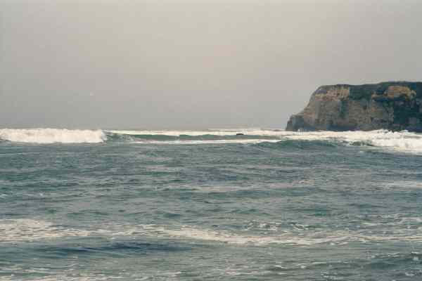
Off in the distance I passed the "Theodore J Hoover National Preserve" (a low valley in the cliffs to me) and caught glimpses of Greyhound Rock through the returning fog bank ahead. This was originally supposed to be my camping spot for the night. But the evening before I had contacted Bryant Austin who offered to put me up at his house in nearby Davenport instead. The rock sort of looks like a Greyhound bus, long and flat with a blunt end. This made me wonder if this was the right rock since most place names on the coast pre-date that kind of transport. The rock is large and points south to provide protection from a northwest swell. As I approached Greyhound Rock I saw some scary waves breaking far from shore. When I was closer, some of these waves rose up and threatened to break on me! I turned out to sea to climb over a set of these and then turned out again over an even larger set! These waves were tall! Over 12 feet and breaking all the way across to the next set of rocks. They were starting to break far from shore, like the swell was larger or there was an extensive reef offshore here. Behind the rock was a vertical sandstone cliff with no trail that I could see. Was I in the right spot? Was I mistaken about where I was? No way was I going to attempt a landing behind this rock.
The fog closed in again and made verifying my position difficult. By the clock I should have been at Greyhound Rock where I had planed to stop for lunch and put on another layer of warm jacket. I had no choice but to continue to Davenport Landing where I was planning on meeting Bryant Austin. The cliffs in this area were steep with waves slamming into reefs or narrow beaches below them. I studied the charts and decided that if Davenport is really ahead of me, then the cliffs will first drop down, the road will be visible for a stretch, the shore will turn out to a small point, and after a 90 degree turn Ill be where I want to be. These things started happening and at the right times by the clock, confirming my location and my preference for using topographic maps instead of navigation charts. But suddenly huge waves were threatening to break around me again. I clawed my way over several sets of these and had to stay so far from shore I wasnt sure I could find the point! When I did and started to turn around it I got scared by another large set of waves and had to go way round the point. I figured that condition must have deteriorated and I was in trouble. How could I possibly make a safe landing with these huge waves pounding the shore? I figured that if I survived this landing the trip was over.
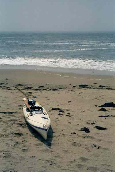
Then the large waves turned to pound the backside of the point. The sea ahead of me flattened out. Parents took their kids down to splash in the water. Surfers paddled out along the point to play in the edges of the big waves. I slid to shore on a calm beach. The sun came out. I shouted "Cheated death again!" but nobody heard me. I guess the trip will continue after all. Konstantin Gortinsky gives me a dirty look every time I point to a place on a coastal chart that has "landing" in the name. He says that he has been burned too many times by arriving at a place named "Something Landing" only to discover that the place is not a good place to land at all! But this was one place that lived up to its name, Davenport Landing, and I was glad it did! I slid my kayak up onto a handicapped ramp, changed my clothes and was about to start rolling my boat to Bryants house when his girlfriend Martha showed up and offered me a ride.