Jailhouse to Toilet Bowl Beach, March 27th, 2008.
Click on the small image to see the full-sized one.
 Thurseve Paddlers getting ready on Jail House Beach
Links to related images: Nearby. Proofs. Map.
Approximate location: 37.9400684814864N / 122.48614311218W.
 Thurseve Paddlers launching from Jail House Beach, heading for Red Rock
Links to related images: Nearby. Proofs. Map.
Approximate location: 37.9400684814864N / 122.48614311218W.

 Thurseve Paddlers heading for Red Rock
Links to related images: Nearby. Proofs. Map.
Approximate location: 37.9349238050393N / 122.45910644531W.
 Penny Wells and Gordon Schanck heading for Red Rock
Links to related images: Nearby. Proofs. Map.
Approximate location: 37.9348561095279N / 122.45447158813W.
 John Boeschen on Jail House Beach
Links to related images: Nearby. Proofs. Map.
Approximate location: 37.9402038628458N / 122.48579978943W.

 Thurseve Paddlers getting ready on Jail House Beach
Links to related images: Nearby. Proofs. Map.
Approximate location: 37.9400684814864N / 122.48605728149W.
 Gordon Schanck on Jail House Beach
Links to related images: Nearby. Proofs. Map.
Approximate location: 37.940271553432N / 122.48614311218W.
 The intrepid kayaker on Jail House Beach
Links to related images: Nearby. Proofs. Map.
Approximate location: 37.9402038628458N / 122.48614311218W.
 Dave Brown on Jail House Beach
Links to related images: Nearby. Proofs. Map.
Approximate location: 37.9401361721973N / 122.48614311218W.

 I wonder why they call this island Red Rock
Links to related images: Nearby. Proofs. Map.
Approximate location: 37.9293810286397N / 122.43225216866W.
 Penny Wells approaching Red Rock
Links to related images: Nearby. Proofs. Map.
Approximate location: 37.9293641034916N / 122.432295084W.
 I wonder why they call this island Red Rock
Links to related images: Nearby. Proofs. Map.
Approximate location: 37.9292117769837N / 122.43212342262W.

 Penny Wells rounding the south end of Red Rock
Links to related images: Nearby. Proofs. Map.
Approximate location: 37.9281454825918N / 122.43092179298W.
 Gordon Schanck rounding the south end of Red Rock
Links to related images: Nearby. Proofs. Map.
Approximate location: 37.9281200944416N / 122.4308681488W.
 I wonder why they call this island Red Rock
Links to related images: Nearby. Proofs. Map.
Approximate location: 37.9281116317229N / 122.43065357208W.
 In the shadow of Red Rock Island
Links to related images: Nearby. Proofs. Map.
Approximate location: 37.9292117769837N / 122.42976307869W.
 Thurseve Paddlers landing on Toilet Bowl Beach on Red Rock Island
Links to related images: Nearby. Proofs. Map.
Approximate location: 37.9302018936437N / 122.43101835251W.
 Penny Wells on Jail House Beach
Links to related images: Nearby. Proofs. Map.
Approximate location: 37.9404746248164N / 122.48622894287W.
 Thurseve Paddlers landing on Toilet Bowl Beach on Red Rock Island
Links to related images: Nearby. Proofs. Map.
Approximate location: 37.929990331375N / 122.43119001389W.
 John Boeschen on Toilet Bowl Beach
Links to related images: Nearby. Proofs. Map.
Approximate location: 37.9299987938774N / 122.43100762367W.
 Thurseve Paddlers on Toilet Bowl Beach
Links to related images: Nearby. Proofs. Map.
Approximate location: 37.9299818688716N / 122.43088960648W.
 Stone soup started with red stones from Red Rock Island
Links to related images: Nearby. Proofs. Map.
Approximate location: 37.9299818688716N / 122.43088960648W.


 John Boeschen sitting next to brussels sprouts on Red Rock Island
Links to related images: Nearby. Proofs. Map.
Approximate location: 37.9299818688716N / 122.43088960648W.
 John Boeschen and Penny Wells Red Rock Island
Links to related images: Nearby. Proofs. Map.
Approximate location: 37.9299818688716N / 122.43088960648W.
 The intrepid kayaker preparing brussel sprouts on Red Rock Island
Links to related images: Nearby. Proofs. Map.
Approximate location: 37.92994N / 122.43105W.


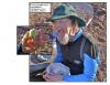
 John Boeschen is willing to try one brussels sprout
Links to related images: Nearby. Proofs. Map.
Approximate location: 37.9300157188794N / 122.4308359623W.
 Gordon Schanck enjoying a brussels sprout
Links to related images: Nearby. Proofs. Map.
Approximate location: 37.9299987938774N / 122.4308681488W.
 Thurseve Paddlers landing on Toilet Bowl Beach on Red Rock Island
Links to related images: Nearby. Proofs. Map.
Approximate location: 37.9300072563789N / 122.43094325066W.
 Dessert on Red Rock Island
Links to related images: Nearby. Proofs. Map.
Approximate location: 37.9300072563789N / 122.43087887764W.


 Camp fire on Red Rock Island
Links to related images: Nearby. Proofs. Map.
Approximate location: 37.9299797532456N / 122.43098884821W.
 John Boeschen packing up to leave Red Rock Island
Links to related images: Nearby. Proofs. Map.
Approximate location: 37.9299966782519N / 122.43106395006W.
 Dave Brown packing up to leave Red Rock Island
Links to related images: Nearby. Proofs. Map.
Approximate location: 37.9299861001234N / 122.43108808994W.
 John Boeschen packing up to leave Red Rock Island
Links to related images: Nearby. Proofs. Map.
Approximate location: 37.9300051407536N / 122.43106663227W.
 Ninja Camping on Red Rock Island
Links to related images: Nearby. Proofs. Map.
Approximate location: 37.9298443530546N / 122.43120074272W.
All text and images Copyright © 2008 by Mike Higgins / contact