Walker Creek, February 10th 2008.
Click on the small image to see the full-sized one.
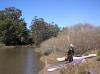 Kate DesLauriers at the Keys Creek put-in
Links to related images: Nearby. Proofs. Map.
Approximate location: 38.2261244305529N / 122.91731357574W.
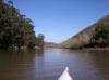
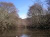
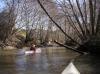
 Paddling up Keys Creek
Links to related images: Nearby. Proofs. Map.
Approximate location: 38.2329341811655N / 122.91520535946W.
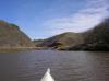
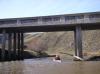
 Under Highway One into the mouth of Walker Creek
Links to related images: Nearby. Proofs. Map.
Approximate location: 38.2327024241439N / 122.91327953339W.

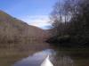 Walker Creek
Links to related images: Nearby. Proofs. Map.
Approximate location: 38.2242027519245N / 122.90973901749W.
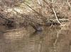 Walker Creek had many turtles
Links to related images: Nearby. Proofs. Map.
Approximate location: 38.2224580260456N / 122.90646135807W.
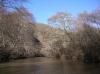 Walker Creek
Links to related images: Nearby. Proofs. Map.
Approximate location: 38.2208481210888N / 122.90321588516W.
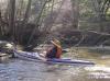 Kate DesLauriers in Walker Creek
Links to related images: Nearby. Proofs. Map.
Approximate location: 38.2230691062958N / 122.90186405182W.
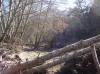
 We were unable to proceed farther up Walker Creek
Links to related images: Nearby. Proofs. Map.
Approximate location: 38.223140749851N / 122.90192306042W.
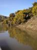 Scotch broom beside Walker Creek
Links to related images: Nearby. Proofs. Map.
Approximate location: 38.2290110672951N / 122.90802240372W.

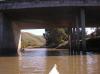
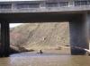 Kate Deslauriers going under Highway One on Walker Creek
Links to related images: Nearby. Proofs. Map.
Approximate location: 38.2324790939516N / 122.91283965111W.
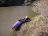 Kate Deslauriers gracefull exiting at the Keys Creek put-in
Links to related images: Nearby. Proofs. Map.
Approximate location: 38.2261160022487N / 122.91731357574W.
All text and images Copyright © 2008 by Mike Higgins / contact