Layover day on Isla San Martin, October 17th 2007.
Click on the small image to see the full-sized one.
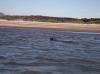
 The harbor seals of Isla San Martin are quick to jump in the water
Links to related images: Nearby. Proofs. Map.
Approximate location: 30.48255N / 116.10555W.
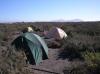

 Our campsite in the lagoon on Isla San Martin
Links to related images: Nearby. Proofs. Map.
Approximate location: 30.48522N / 116.10712W.

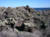
 Shaggy lichen everywhere makes rocks look like bushes
Links to related images: Nearby. Proofs. Map.
Approximate location: 30.48644N / 116.11019W.
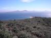
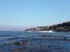
 The cove on Isla San Martin and San Quintin in the distance
Links to related images: Nearby. Proofs. Map.
Approximate location: 30.48644N / 116.11019W.
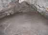
 A small lava tube, I never found the large ones
Links to related images: Nearby. Proofs. Map.
Approximate location: 30.4874N / 116.11171W.

 Poles on the smaller peak of Isla San Martin
Links to related images: Nearby. Proofs. Map.
Approximate location: 30.48865N / 116.11403W.
 A falcon asked me to leave the small peak of Isla San Martin
Links to related images: Nearby. Proofs. Map.
Approximate location: 30.48865N / 116.11403W.
 Old iron tower on top of Isla San Martin
Links to related images: Nearby. Proofs. Map.
Approximate location: 30.48755N / 116.1147W.
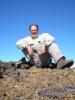 The intrepid kayaker on top of Isla San Martin
Links to related images: Nearby. Proofs. Map.
Approximate location: 30.48755N / 116.11467W.
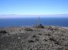
 The top of Isla San Martin
Links to related images: Nearby. Proofs. Map.
Approximate location: 30.48755N / 116.11467W.
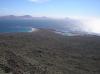
 The cove on Isla San Martin and San Quintin in the distance
Links to related images: Nearby. Proofs. Map.
Approximate location: 30.48755N / 116.11467W.


 A panorama of the cone in the top of Isla San Martin
Links to related images: Nearby. Proofs. Map.
Approximate location: 30.48755N / 116.11467W.
 Looking down at the light on the south end of Isla San Martin
Links to related images: Nearby. Proofs. Map.
Approximate location: 30.48704N / 116.11476W.
 Looking down at the cove and the lagoon on Isla San Martin
Links to related images: Nearby. Proofs. Map.
Approximate location: 30.48755N / 116.1145W.
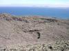 I hiked up this rugged ridge to get to the top of Isla San Martin
Links to related images: Nearby. Proofs. Map.
Approximate location: 30.48758N / 116.1145W.
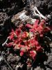
 Cactus flowers on Isla San Martin
Links to related images: Nearby. Proofs. Map.
Approximate location: 30.48682N / 116.11304W.


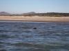
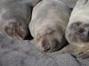
 Elephant seals in the Isla San Martin lagoon
Links to related images: Nearby. Proofs. Map.
Approximate location: 30.48335N / 116.10646W.
 Cactus flowers on Isla San Martin
Links to related images: Nearby. Proofs. Map.
Approximate location: 30.48339N / 116.10646W.
 Elephant seals in the Isla San Martin lagoon
Links to related images: Nearby. Proofs. Map.
Approximate location: 30.48247N / 116.1056W.
 Gregg Berman exiting the Isla San Martin lagoon
Links to related images: Nearby. Proofs. Map.
Approximate location: 30.48247N / 116.1056W.

 Gregg Berman paddling up the south side of Isla San Martin
Links to related images: Nearby. Proofs. Map.
Approximate location: 30.48243N / 116.12253W.
 The light on the south end of Isla San Martin
Links to related images: Nearby. Proofs. Map.
Approximate location: 30.48243N / 116.12253W.

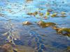
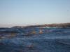
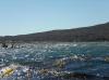
 Kelp makes paddling around Isla San Martin a workout
Links to related images: Nearby. Proofs. Map.
Approximate location: 30.49843N / 116.11296W.
 The kelp thins out on the north end of Isla San Martin
Links to related images: Nearby. Proofs. Map.
Approximate location: 30.49551N / 116.1074W.

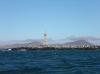
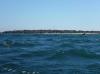
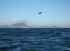 Looking across to San Quintin Bay
Links to related images: Nearby. Proofs. Map.
Approximate location: 30.49382N / 116.10633W.

 Looking into the cove on Isla San Martin
Links to related images: Nearby. Proofs. Map.
Approximate location: 30.48766N / 116.10409W.

 Gregg Berman approaching the natural breakwater on Isla San Martin
Links to related images: Nearby. Proofs. Map.
Approximate location: 30.48545N / 116.0998W.
 We surfed over the low spot in the natural breakwater
Links to related images: Nearby. Proofs. Map.
Approximate location: 30.48476N / 116.09948W.
 Succulent flowers on Isla San Martin
Links to related images: Nearby. Proofs. Map.
Approximate location: 30.48333N / 116.10656W.
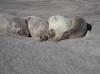

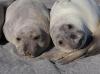 Elephant seals on Isla San Martin
Links to related images: Nearby. Proofs. Map.
Approximate location: 30.48238N / 116.10729W.
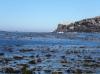
 Looking out the entrance to the lagoon on Isla San Martin
Links to related images: Nearby. Proofs. Map.
Approximate location: 30.48238N / 116.10729W.
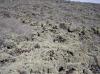
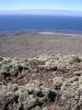
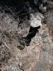
 Tortured lava terrain on Isla San Martin
Links to related images: Nearby. Proofs. Map.
Approximate location: 30.48148N / 116.10924W.
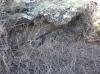
 I searched but only found small lava tubes on Isla San Martin
Links to related images: Nearby. Proofs. Map.
Approximate location: 30.48103N / 116.11012W.
 Cactus flower s on Isla San Martin
Links to related images: Nearby. Proofs. Map.
Approximate location: 30.48088N / 116.11049W.
 Isla San Martin lagoon viewed from lava fields
Links to related images: Nearby. Proofs. Map.
Approximate location: 30.48071N / 116.11096W.
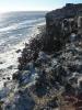
 Looking down the cliffs on the south end of Isla San Martin
Links to related images: Nearby. Proofs. Map.
Approximate location: 30.48077N / 116.11096W.
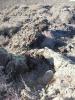
 Tortured lava terrain on Isla San Martin
Links to related images: Nearby. Proofs. Map.
Approximate location: 30.482N / 116.11158W.


 I searched but only found small lava tubes on Isla San Martin
Links to related images: Nearby. Proofs. Map.
Approximate location: 30.48236N / 116.10781W.
 Charles Harris with one of the lobsters that the panga fishermen gave us for dinner
Links to related images: Nearby. Proofs. Map.
Approximate location: 30.48339N / 116.10577W.
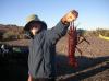
 Gregg Berman with one of the lobsters that the panga fishermen gave us for dinner
Links to related images: Nearby. Proofs. Map.
Approximate location: 30.48339N / 116.10577W.
All text and images Copyright © 2007 by Mike Higgins / contact