Montara Beach to Pigeon Point, September 22nd to 23rd 2007.
Click on the small image to see the full-sized one.
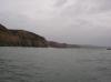
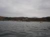
 The beach behind Eel Rock
Links to related images: Nearby. Proofs. Map.
Approximate location: 37.392732056714N / 122.42434501648W.
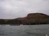
 Limestone cliffs south of Half Moon Bay
Links to related images: Nearby. Proofs. Map.
Approximate location: 37.392391097108N / 122.42383003235W.
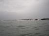 Water washing over Eel Rock
Links to related images: Nearby. Proofs. Map.
Approximate location: 37.3921183283065N / 122.423787117W.
 The cove in front of the town of Martins Beach
Links to related images: Nearby. Proofs. Map.
Approximate location: 37.3757162803207N / 122.41181373596W.


 The Pigeon Point Lighthouse
Links to related images: Nearby. Proofs. Map.
Approximate location: 37.1812961431807N / 122.39351570606W.


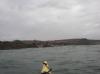
 Gregg Berman hanging out gear behind the Pigeon Point Lighthouse
Links to related images: Nearby. Proofs. Map.
Approximate location: 37.1817876490502N / 122.39430963993W.
 The Pigeon Point Lighthouse
Links to related images: Nearby. Proofs. Map.
Approximate location: 37.1819671547444N / 122.39411115646W.
All text and images Copyright © 2007 by Mike Higgins / contact