Heceta Head to Florence Oregon, August 15th 2007.
Click on the small image to see the full-sized one.

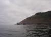
 The view out my tent at low tide in the morning
Links to related images: Nearby. Proofs. Map.
Approximate location: 44.13682N / 124.1262W.
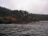
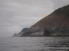
 Our campsite at Heceta Head in the morning with low tide
Links to related images: Nearby. Proofs. Map.
Approximate location: 44.13682N / 124.1262W.
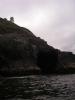
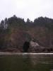
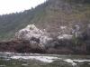
 Arch to narrow to go through at Heceta Head
Links to related images: Nearby. Proofs. Map.
Approximate location: 44.13663N / 124.12819W.
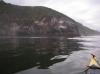
 Our campsite at Heceta Head in the morning with low tide
Links to related images: Nearby. Proofs. Map.
Approximate location: 44.13669N / 124.12899W.


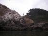
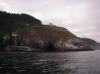
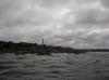
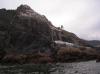 The Heceta Lighthouse viewed from below
Links to related images: Nearby. Proofs. Map.
Approximate location: 44.13862N / 124.12922W.
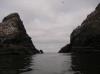
 Slot between rocks at Heceta Head
Links to related images: Nearby. Proofs. Map.
Approximate location: 44.13869N / 124.12922W.
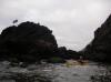
 Another slot that had no exit at low tide
Links to related images: Nearby. Proofs. Map.
Approximate location: 44.13631N / 124.12753W.
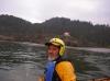
 Dick Ryon in the no exit slot
Links to related images: Nearby. Proofs. Map.
Approximate location: 44.13637N / 124.12815W.
 Keep Off sign on the rocks at no exit slot
Links to related images: Nearby. Proofs. Map.
Approximate location: 44.13637N / 124.12815W.

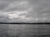
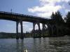
 Highway 101 bridge at Heceta Head
Links to related images: Nearby. Proofs. Map.
Approximate location: 44.13564N / 124.12841W.
 Looking back at the Heceta Lighthouse
Links to related images: Nearby. Proofs. Map.
Approximate location: 44.1356N / 124.12817W.
 The Heceta Lighthouse keepers house
Links to related images: Nearby. Proofs. Map.
Approximate location: 44.13562N / 124.12753W.
 Highway 101 bridge at Heceta Head
Links to related images: Nearby. Proofs. Map.
Approximate location: 44.13562N / 124.12753W.
 Looking back at the Heceta Lighthouse
Links to related images: Nearby. Proofs. Map.
Approximate location: 44.13521N / 124.12725W.
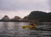
 Rock gardening at Devils Elbow
Links to related images: Nearby. Proofs. Map.
Approximate location: 44.13345N / 124.12663W.
 Dick Ryon in front of the Heceta Lighthouse
Links to related images: Nearby. Proofs. Map.
Approximate location: 44.13302N / 124.12665W.
 Dick Ryon in front of the Heceta Lighthouse keepers house
Links to related images: Nearby. Proofs. Map.
Approximate location: 44.13296N / 124.12663W.
 Rock gardening at Devils Elbow
Links to related images: Nearby. Proofs. Map.
Approximate location: 44.13109N / 124.1266W.

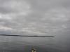
 Cape Cove beach we could have camped on
Links to related images: Nearby. Proofs. Map.
Approximate location: 44.12882N / 124.12686W.

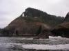
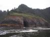
 Caves and cliffs near Sea Lion Point
Links to related images: Nearby. Proofs. Map.
Approximate location: 44.12534N / 124.12768W.
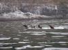
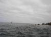
 Sea lions eveywhere in the water
Links to related images: Nearby. Proofs. Map.
Approximate location: 44.12519N / 124.12774W.
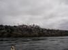
 The Sea Lion Caves facility on the cliff
Links to related images: Nearby. Proofs. Map.
Approximate location: 44.1236N / 124.13055W.

 Sea lions eveywhere in the water
Links to related images: Nearby. Proofs. Map.
Approximate location: 44.12009N / 124.1312W.

 Caves at Sea Lion Caves that we may not approach
Links to related images: Nearby. Proofs. Map.
Approximate location: 44.11813N / 124.12993W.
 You can see through this giant sea lion cave!
Links to related images: Nearby. Proofs. Map.
Approximate location: 44.11633N / 124.1286W.
 We come close to shore again past Sea Lion Caves
Links to related images: Nearby. Proofs. Map.
Approximate location: 44.11178N / 124.12744W.
 Approaching the Siuslaw River Jetty
Links to related images: Nearby. Proofs. Map.
Approximate location: 44.02288N / 124.14649W.
 The Y shaped end of the jetty is good at catching driftwood
Links to related images: Nearby. Proofs. Map.
Approximate location: 44.0199N / 124.14752W.
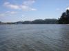
 Entering the Siuslaw River
Links to related images: Nearby. Proofs. Map.
Approximate location: 44.01872N / 124.14581W.
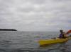
 Dick Ryon entering the Siuslaw River
Links to related images: Nearby. Proofs. Map.
Approximate location: 44.01883N / 124.14557W.
 The Y shaped end of the jetty is good at catching driftwood
Links to related images: Nearby. Proofs. Map.
Approximate location: 44.01868N / 124.1451W.
 Dick Ryon entering the Siuslaw River
Links to related images: Nearby. Proofs. Map.
Approximate location: 44.01857N / 124.14422W.
 Harbor seals hauled out on the Siuslaw River
Links to related images: Nearby. Proofs. Map.
Approximate location: 44.00218N / 124.12605W.
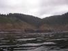
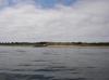
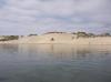 Giant sand dunes line the south side of the Siuslaw River
Links to related images: Nearby. Proofs. Map.
Approximate location: 43.98128N / 124.12624W.
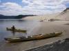
 Dick Ryon and I stop for lunch by a sand dune on the Siuslaw River
Links to related images: Nearby. Proofs. Map.
Approximate location: 43.96471N / 124.11517W.
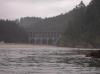
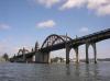
 The Highway 101 bridge over the Siuslaw River
Links to related images: Nearby. Proofs. Map.
Approximate location: 43.96439N / 124.11369W.
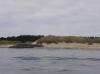
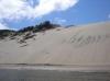 Giant sand dunes line the south side of the Siuslaw River
Links to related images: Nearby. Proofs. Map.
Approximate location: 43.96439N / 124.11369W.
 The Highway 101 bridge over the Siuslaw River
Links to related images: Nearby. Proofs. Map.
Approximate location: 43.96286N / 124.10824W.
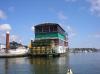 Paddle wheel boat at the Florence marina
Links to related images: Nearby. Proofs. Map.
Approximate location: 43.96735N / 124.10169W.
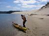
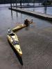 Dick Ryon and I land at the end of a sucessful trip
Links to related images: Nearby. Proofs. Map.
Approximate location: 43.96821N / 124.10167W.
All text and images Copyright © 2007 by Mike Higgins / contact