Tillamook Bay to Cape Lookout, August 9th 2007.
Click on the small image to see the full-sized one.
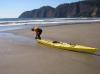
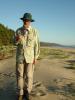 The intrepid kayaker on the beach near Cape Lookout, Oregon
Links to related images: Nearby. Proofs. Map.
Approximate location: 45.3321766972351N / 123.97058486938W.
 Dick Ryon launching off the beach behind the Tillamook Bay south jetty
Links to related images: Nearby. Proofs. Map.
Approximate location: 45.56429N / 123.95623W.
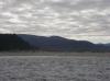
 Two arches visible in Three Arch Rocks past Cape Meares
Links to related images: Nearby. Proofs. Map.
Approximate location: 45.50093N / 123.97528W.
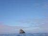
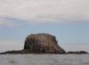
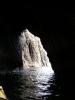
 Pillar Rock
Links to related images: Nearby. Proofs. Map.
Approximate location: 45.49288N / 123.97606W.
 Arrived at Cape Meares
Links to related images: Nearby. Proofs. Map.
Approximate location: 45.49288N / 123.97606W.
 Rock gardening at Cape Meares
Links to related images: Nearby. Proofs. Map.
Approximate location: 45.49078N / 123.97696W.
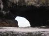
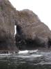
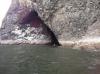
 Arch close to the cliffs at Cape Meares
Links to related images: Nearby. Proofs. Map.
Approximate location: 45.49067N / 123.97704W.
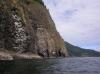
 Main point of Cape Meares
Links to related images: Nearby. Proofs. Map.
Approximate location: 45.49018N / 123.97713W.
 Basalt columns on Cape Meares
Links to related images: Nearby. Proofs. Map.
Approximate location: 45.48893N / 123.97588W.
 Dick Ryon at Cape Meares
Links to related images: Nearby. Proofs. Map.
Approximate location: 45.48883N / 123.97578W.
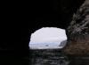
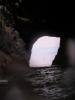
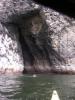
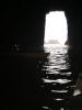 Cave in Cape Meares
Links to related images: Nearby. Proofs. Map.
Approximate location: 45.48698N / 123.97361W.
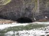
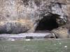 Cave with gravel beach
Links to related images: Nearby. Proofs. Map.
Approximate location: 45.48329N / 123.97312W.
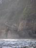
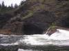
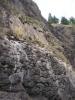
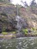 Waterfall at Cape Meares
Links to related images: Nearby. Proofs. Map.
Approximate location: 45.4819N / 123.97239W.
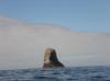
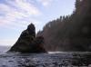
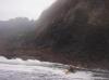
 Rock near Lost Boy Cave
Links to related images: Nearby. Proofs. Map.
Approximate location: 45.46533N / 123.98249W.
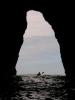
 First arch in Three Arch Rocks
Links to related images: Nearby. Proofs. Map.
Approximate location: 45.46411N / 123.98679W.
 Dick Ryon between the Three Arch Rocks
Links to related images: Nearby. Proofs. Map.
Approximate location: 45.46454N / 123.98822W.
 Second arch in Three Arch Rocks
Links to related images: Nearby. Proofs. Map.
Approximate location: 45.46314N / 123.98854W.
 Third arch in Three Arch Rocks
Links to related images: Nearby. Proofs. Map.
Approximate location: 45.46192N / 123.98981W.
 Dick Ryon in third arch in Three Arch Rocks
Links to related images: Nearby. Proofs. Map.
Approximate location: 45.46192N / 123.98981W.
 Third arch in Three Arch Rocks
Links to related images: Nearby. Proofs. Map.
Approximate location: 45.46087N / 123.99048W.
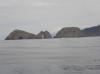 Looking back at Three Arch Rocks
Links to related images: Nearby. Proofs. Map.
Approximate location: 45.44593N / 123.99106W.
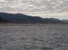
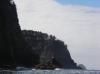
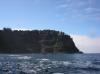
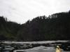
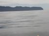 Looking ahead to Cape Lookout
Links to related images: Nearby. Proofs. Map.
Approximate location: 45.39752N / 123.99681W.
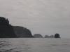
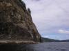
 Approaching Cape Lookout
Links to related images: Nearby. Proofs. Map.
Approximate location: 45.34362N / 123.99631W.
 Landable beach on north side of Cape Lookout
Links to related images: Nearby. Proofs. Map.
Approximate location: 45.34182N / 123.99492W.
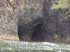
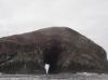
 Nostril Cave in Cape Lookout
Links to related images: Nearby. Proofs. Map.
Approximate location: 45.3409N / 124.00093W.


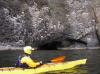
 Dick Ryon inside left Nostril Cave
Links to related images: Nearby. Proofs. Map.
Approximate location: 45.34077N / 124.00284W.
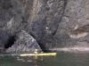
 Another cave on the south side of Cape Lookout
Links to related images: Nearby. Proofs. Map.
Approximate location: 45.34034N / 124.00369W.
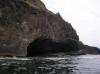
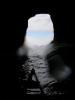
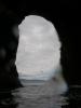
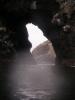
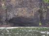
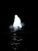
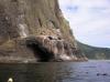
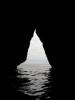
 Big cave in the tip of Cape Lookout
Links to related images: Nearby. Proofs. Map.
Approximate location: 45.33856N / 124.00867W.
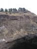
 Pillow basalt at tip of Cape Lookout
Links to related images: Nearby. Proofs. Map.
Approximate location: 45.33643N / 124.00608W.
 Hikers on the tip of Cape Lookout
Links to related images: Nearby. Proofs. Map.
Approximate location: 45.33646N / 124.00543W.
 First view around the south side of Cape Lookout
Links to related images: Nearby. Proofs. Map.
Approximate location: 45.33646N / 124.00543W.
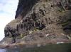
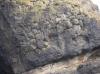
 Pillow and column basalt on Cape Lookout
Links to related images: Nearby. Proofs. Map.
Approximate location: 45.33667N / 124.00136W.
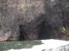
 Cave in the south side of Cape Lookout
Links to related images: Nearby. Proofs. Map.
Approximate location: 45.33652N / 124.00082W.
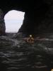
 Dick Ryon in a cave in the south side of Cape Lookout
Links to related images: Nearby. Proofs. Map.
Approximate location: 45.33652N / 124.00082W.
 Pillow basalt on the south side of Cape Lookout
Links to related images: Nearby. Proofs. Map.
Approximate location: 45.33656N / 123.99887W.
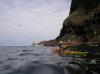
 Dick Ryon paddling down the south side of Cape Lookout
Links to related images: Nearby. Proofs. Map.
Approximate location: 45.33787N / 123.99114W.

 Cave/arch on the south side of Cape Lookout
Links to related images: Nearby. Proofs. Map.
Approximate location: 45.33787N / 123.99114W.
 The base of Cape Lookout
Links to related images: Nearby. Proofs. Map.
Approximate location: 45.33774N / 123.98492W.
 Dick Ryon landed south of Cape Lookout
Links to related images: Nearby. Proofs. Map.
Approximate location: 45.3277N / 123.97001W.
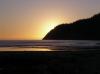 Sunset over Cape Lookout
Links to related images: Nearby. Proofs. Map.
Approximate location: 45.32777N / 123.96805W.
All text and images Copyright © 2007 by Mike Higgins / contact