Punta Santa Rosa to Arroyo Verde, April 3rd 2007.
Click on the small image to see the full-sized one.
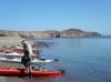
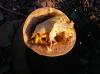 Breakfast tacos with eggs donated by 'The Girls'
Links to related images: Nearby. Proofs. Map.
Approximate location: 26.7604N / 111.65708W.

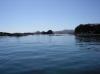
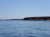
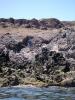
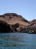
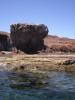
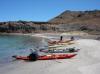
 Beautiful basalt cliffs and green water south of Punta Santa Rosa
Links to related images: Nearby. Proofs. Map.
Approximate location: 26.7604N / 111.65708W.

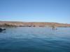
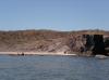
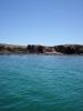
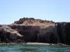
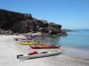
 More campable beaches south of Punta Santa Rosa
Links to related images: Nearby.
Approximate location: 26.74104N / 111.62687E.
 Kate DesLauriers in front of low bluffs
Links to related images: Nearby. Proofs. Map.
Approximate location: 26.74113N / 111.62674W.
 Don Fleming in front of low bluffs
Links to related images: Nearby. Proofs. Map.
Approximate location: 26.74113N / 111.62674W.
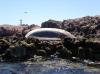
 Dead whale in front of panga fishing camp
Links to related images: Nearby. Proofs. Map.
Approximate location: 26.73774N / 111.62629W.
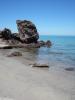
 There is supposed to be a lagoon here, we found simply scrub
Links to related images: Nearby. Proofs. Map.
Approximate location: 26.73336N / 111.62712W.

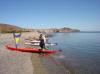
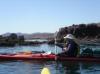
 Herb Howe watches the kayaks on a break stop
Links to related images: Nearby. Proofs. Map.
Approximate location: 26.73336N / 111.62712W.
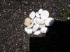 Kate DesLauriers collects shells ground and polished into rocks
Links to related images: Nearby. Proofs. Map.
Approximate location: 26.73336N / 111.62712W.
 Approaching Punta Santa Teresa
Links to related images: Nearby. Proofs. Map.
Approximate location: 26.72793N / 111.61079W.
 A herd of goats on shore
Links to related images: Nearby.
Approximate location: 26.71858N / 111.605W.
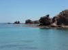
 Approaching Punta Santa Teresa
Links to related images: Nearby. Proofs. Map.
Approximate location: 26.71804N / 111.60039W.
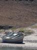
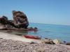
 Wrecks of several boats on shore
Links to related images: Nearby. Proofs. Map.
Approximate location: 26.71317N / 111.58977W.
 My kayak over electric blue water
Links to related images: Nearby. Proofs. Map.
Approximate location: 26.71317N / 111.58977W.
 I caught a great blue heron in flight
Links to related images: Nearby. Proofs. Map.
Approximate location: 26.71317N / 111.58977W.
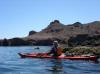
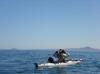
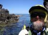 Self portrait of the intrepid kayaker
Links to related images: Nearby. Proofs. Map.
Approximate location: 26.71302N / 111.58934W.
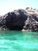
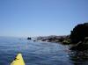
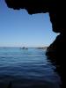
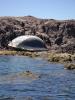
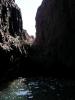
 Blue water in front of a cave
Links to related images: Nearby. Proofs. Map.
Approximate location: 26.71173N / 111.58798W.
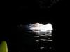
 Kate DesLauriers viewed from inside a cave
Links to related images: Nearby. Proofs. Map.
Approximate location: 26.7116N / 111.58809W.

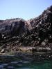 Jagged volcanic rocks on shore
Links to related images: Nearby. Proofs. Map.
Approximate location: 26.71158N / 111.58809W.
 Kate DesLauriers passing by pelicans
Links to related images: Nearby. Proofs. Map.
Approximate location: 26.71244N / 111.58382W.

 Andrea Wolf rounds a rocky point past a sandy beach
Links to related images: Nearby. Proofs. Map.
Approximate location: 26.71251N / 111.58211W.
 Doug Hamilton rounds a rocky point past a sandy beach
Links to related images: Nearby. Proofs. Map.
Approximate location: 26.71251N / 111.58211W.
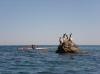
 Rocks off Punta Santa Teresa
Links to related images: Nearby. Proofs. Map.
Approximate location: 26.71251N / 111.58211W.
 Doug Hamilton south of Punta Santa Teresa
Links to related images: Nearby. Proofs. Map.
Approximate location: 26.70794N / 111.57543W.
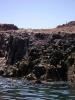
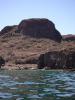
 Cliffs south of Punta Santa Teresa
Links to related images: Nearby. Proofs. Map.
Approximate location: 26.70819N / 111.57498W.
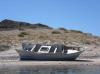
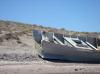
 Wrecked boat, we didn't bring enough ducttape to fix this one
Links to related images: Nearby. Proofs. Map.
Approximate location: 26.70806N / 111.57198W.
 Andrea Wolf in front of Punta Santa Teresa
Links to related images: Nearby. Proofs. Map.
Approximate location: 26.70688N / 111.57095W.
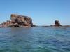
 Rocks off Punta Santa Teresa
Links to related images: Nearby. Proofs. Map.
Approximate location: 26.70688N / 111.57095W.
 Cliffs south of Punta Santa Teresa
Links to related images: Nearby. Proofs. Map.
Approximate location: 26.70027N / 111.57045W.
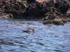 Boobie washing off in the water
Links to related images: Nearby. Proofs. Map.
Approximate location: 26.69759N / 111.56653W.


 Everyone topping for a lunch break
Links to related images: Nearby. Proofs. Map.
Approximate location: 26.69701N / 111.56672W.
 Blue water and rocky point
Links to related images: Nearby. Proofs. Map.
Approximate location: 26.69701N / 111.56672W.
 Doug Hamilton south of Punta Santa Teresa
Links to related images: Nearby. Proofs. Map.
Approximate location: 26.69663N / 111.56097W.
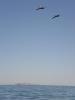 Pelicans in front of Isla San Idelfonzo
Links to related images: Nearby. Proofs. Map.
Approximate location: 26.69652N / 111.56095W.
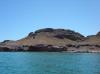
 Mesa south of Punta Santa Teresa
Links to related images: Nearby. Proofs. Map.
Approximate location: 26.69249N / 111.56078W.

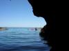
 Doug Hamilton, Don Fleming and I enter a long crack in the cliff
Links to related images: Nearby. Proofs. Map.
Approximate location: 26.6915N / 111.5614W.
 Herb Howe with Punta El Pulpito in the distance
Links to related images: Nearby. Proofs. Map.
Approximate location: 26.69103N / 111.56095W.
All text and images Copyright © 2007 by Mike Higgins / contact