Meeting the Queen Mary 2, February 4th 2007.
Click on the small image to see the full-sized one.
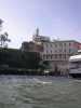
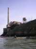
 Approaching Alcatraz Island
Links to related images: Nearby. Proofs. Map.
Approximate location: 37.827887153902N / 122.43267059326W.
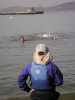
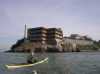 Glenn Nunez approaching Alcatraz Island
Links to related images: Nearby. Proofs. Map.
Approximate location: 37.8276837718136N / 122.42623329163W.
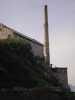
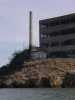 Power Plant smokestack on Alcatraz Island
Links to related images: Nearby. Proofs. Map.
Approximate location: 37.8279549478069N / 122.4257183075W.
 Glenn Nunez and John Harmon at Alcatraz Island
Links to related images: Nearby. Proofs. Map.
Approximate location: 37.8276837718136N / 122.42554664612W.
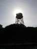
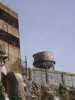 Water Tower on Alcatraz Island
Links to related images: Nearby. Proofs. Map.
Approximate location: 37.8272092114274N / 122.42511749268W.
 Roger's Secret Ninja Camp on Alcatraz Island
Links to related images: Nearby. Proofs. Map.
Approximate location: 37.826327876899N / 122.42434501648W.
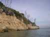
 Alcatraz Island up close
Links to related images: Nearby. Proofs. Map.
Approximate location: 37.8259211035666N / 122.42374420166W.
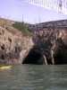
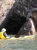 Caves (and John Harmon) on Alcatraz Island
Links to related images: Nearby. Proofs. Map.
Approximate location: 37.8260566949265N / 122.42357254028W.

 Buildings on Alcatraz Island
Links to related images: Nearby. Proofs. Map.
Approximate location: 37.8257855119575N / 122.42322921753W.
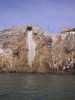
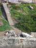
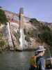
 Drainage flume on Alcatraz Island
Links to related images: Nearby. Proofs. Map.
Approximate location: 37.8255821240767N / 122.42297172546W.
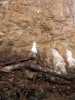 Sea gull on pile of junk on Alcatraz Island
Links to related images: Nearby. Proofs. Map.
Approximate location: 37.8254465318448N / 122.4227142334W.
 Pile of junk on Alcatraz Island
Links to related images: Nearby. Proofs. Map.
Approximate location: 37.8253787356354N / 122.42262840271W.

 Canadian goose (and Glenn Nunez) on Alcatraz Island
Links to related images: Nearby. Proofs. Map.
Approximate location: 37.8253109393637N / 122.42237091064W.

 Century Plants on Alcatraz Island
Links to related images: Nearby. Proofs. Map.
Approximate location: 37.8252431430298N / 122.42056846619W.
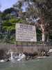 A state park sign on Alcatraz Island that I don't mind obeying
Links to related images: Nearby. Proofs. Map.
Approximate location: 37.8252431430298N / 122.42056846619W.
 Tourist ferry arriving on Alcatraz Island
Links to related images: Nearby. Proofs. Map.
Approximate location: 37.8257177160595N / 122.42039680481W.
 Lighthouse tower on Alcatraz Island
Links to related images: Nearby. Proofs. Map.
Approximate location: 37.8269380326936N / 122.42116928101W.
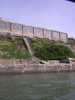
 North shore of Alcatraz Island
Links to related images: Nearby. Proofs. Map.
Approximate location: 37.8271414168374N / 122.42151260376W.
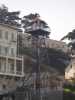 Guard Tower on Alcatraz Island
Links to related images: Nearby. Proofs. Map.
Approximate location: 37.8274803891647N / 122.42211341858W.
 Water Tower on Alcatraz Island
Links to related images: Nearby. Proofs. Map.
Approximate location: 37.8274803891647N / 122.42211341858W.
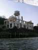
 Power Plant Stack on Alcatraz Island
Links to related images: Nearby. Proofs. Map.
Approximate location: 37.8284295033972N / 122.42408752441W.
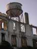 Water tower on Alcatraz Island
Links to related images: Nearby. Proofs. Map.
Approximate location: 37.8284295033972N / 122.42408752441W.
 Power Plant Stack on Alcatraz Island
Links to related images: Nearby. Proofs. Map.
Approximate location: 37.8284295033972N / 122.42520332336W.
 Backlit water tower on Alcatraz Island
Links to related images: Nearby. Proofs. Map.
Approximate location: 37.8284295033972N / 122.42477416992W.
 BASKers on west end of Alcatraz Island
Links to related images: Nearby. Proofs. Map.
Approximate location: 37.8282939163971N / 122.42537498474W.
 Sailing Ship and Transamerica Pyramid on the San Fransisco Skyline
Links to related images: Nearby. Proofs. Map.
Approximate location: 37.8145983461313N / 122.42383003235W.
 Joe Petolino watching visiting Check Replublic musicians swimming at Aquatic Park
Links to related images: Nearby. Proofs. Map.
Approximate location: 37.8070036675226N / 122.42348670959W.
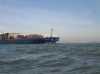
 Container ship passing behind me crossing the San Francisco Bay
Links to related images: Nearby. Proofs. Map.
Approximate location: 37.8308022355693N / 122.46648788452W.


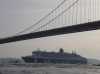
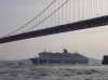 The Queen Mary 2 passes under the Golden Gate Bridge
Links to related images: Nearby. Proofs. Map.
Approximate location: 37.8275142863117N / 122.47713088989W.
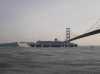
 The fire ship precedes the Queen Mary 2 passes under the Golden Gate Bridge
Links to related images: Nearby. Proofs. Map.
Approximate location: 37.82737869763N / 122.47687339783W.
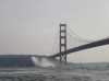
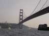
 The Queen Mary 2 passes under the Golden Gate Bridge
Links to related images: Nearby. Proofs. Map.
Approximate location: 37.8269380326936N / 122.47674465179W.
 A Coast Guard Helicoptor approaches the Golden Gate Bridge
Links to related images: Nearby. Proofs. Map.
Approximate location: 37.8269041352819N / 122.47674465179W.
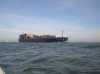
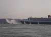
 A cargo ship exits under the Golden Gate Bridge
Links to related images: Nearby. Proofs. Map.
Approximate location: 37.8267346479893N / 122.47670173645W.
All text and images Copyright © 2007 by Mike Higgins / contact