Vietnam, Ile Du Brandon , November 21st 2006.
Click on the small image to see the full-sized one.
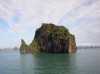


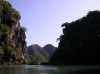
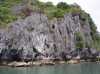
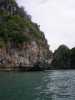
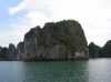
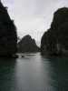
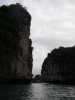
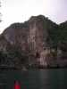
 Karsks on the northwest end of Ile Du Brandon
Links to related images: Nearby. Proofs. Map.
Approximate location: 20.88256N / 107.18451E.
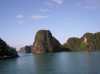
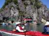
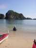
 Finally in a kayak in Halong Bay
Links to related images: Nearby. Proofs. Map.
Approximate location: 20.88256N / 107.18451E.
 Kate DesLauriers paddling past a floating village on Ile Du Brandon
Links to related images: Nearby. Proofs. Map.
Approximate location: 20.88256N / 107.18451E.

 Paddling past a floating village on Ile Du Brandon
Links to related images: Nearby. Proofs. Map.
Approximate location: 20.88256N / 107.18451E.
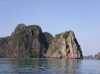
 A view out into the open sea from Ile Du Brandon
Links to related images: Nearby. Proofs. Map.
Approximate location: 20.88256N / 107.18451E.

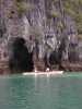
 Landing to look into small cave on Ile Du Brandon
Links to related images: Nearby. Proofs. Map.
Approximate location: 20.88256N / 107.18451E.
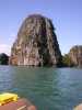
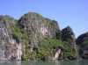
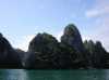
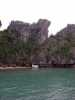
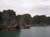
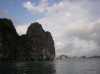
 Vertical limestone sides of Ile Du Brandon
Links to related images: Nearby. Proofs. Map.
Approximate location: 20.88256N / 107.18451E.
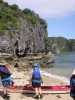
 Maryly Snow stoped for a break on a sandy beach on Ile Du Brandon
Links to related images: Nearby. Proofs. Map.
Approximate location: 20.86842N / 107.2009E.
 Jim and Susan Wiltshire on a sandy beach on Ile Du Brandon
Links to related images: Nearby. Proofs. Map.
Approximate location: 20.86842N / 107.2009E.
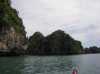
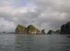
 Continuing around Ile Du Brandon
Links to related images: Nearby. Proofs. Map.
Approximate location: 20.86842N / 107.2009E.
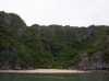 Another low tide sandy beach on Ile Du Brandon
Links to related images: Nearby. Proofs. Map.
Approximate location: 20.86842N / 107.2009E.
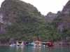
 Another floating village on Ile Du Brandon
Links to related images: Nearby. Proofs. Map.
Approximate location: 20.86842N / 107.2009E.
 Kate DesLauriers and Maryly Snow in front of cave on Ile Du Brandon
Links to related images: Nearby. Proofs. Map.
Approximate location: 20.89072N / 107.20176E.
 Continuing around Ile Du Brandon
Links to related images: Nearby. Proofs. Map.
Approximate location: 20.89072N / 107.20176E.
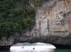
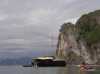 Back to our support boat at Ile Du Brandon
Links to related images: Nearby. Proofs. Map.
Approximate location: 20.89072N / 107.20176E.
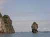 Delicate karsk by Ile Du Brandon
Links to related images: Nearby. Proofs. Map.
Approximate location: 20.89072N / 107.20176E.

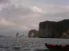
 Motoring between islands in our support boat
Links to related images: Nearby. Proofs. Map.
Approximate location: 20.83448N / 107.1779E.
 Floating village on Ile Des Arenes
Links to related images: Nearby. Proofs. Map.
Approximate location: 20.83555N / 107.16161E.
 Giant arch visible from our support boat on Ile Des Arenes
Links to related images: Nearby. Proofs. Map.
Approximate location: 20.83555N / 107.16161E.
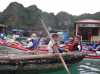
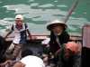 People from floating village try to sell us shellfish
Links to related images: Nearby. Proofs. Map.
Approximate location: 20.83555N / 107.16161E.
 We start off for an afternoon paddle in kayaks around Ile Des Arenes
Links to related images: Nearby. Proofs. Map.
Approximate location: 20.83555N / 107.16161E.
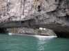 The support boat viewed under the huge arch
Links to related images: Nearby. Proofs. Map.
Approximate location: 20.83257N / 107.16094E.
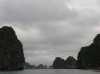 Karsks croud out the horizon in most directions
Links to related images: Nearby. Proofs. Map.
Approximate location: 20.83257N / 107.16094E.
 A sandy beach, but only at low tide
Links to related images: Nearby. Proofs. Map.
Approximate location: 20.8284N / 107.1679E.
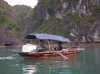
 Local fishermen live on their boats
Links to related images: Nearby. Proofs. Map.
Approximate location: 20.82926N / 107.16946E.
 karsks and dramatic sky
Links to related images: Nearby. Proofs. Map.
Approximate location: 20.82969N / 107.17062E.
 Rounding Ile Des Arenes by kayak
Links to related images: Nearby. Proofs. Map.
Approximate location: 20.82969N / 107.17062E.
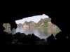
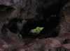 Looking through a cave at greenery on the other side
Links to related images: Nearby. Proofs. Map.
Approximate location: 20.83712N / 107.17303E.
 Needle thin karsk and dramatic sky
Links to related images: Nearby. Proofs. Map.
Approximate location: 20.83712N / 107.17303E.
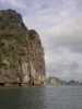
 Kayaks approaching steep limestone cliffs
Links to related images: Nearby. Proofs. Map.
Approximate location: 20.84263N / 107.17049E.
 Kayaks going through the narrow shallow places
Links to related images: Nearby. Proofs. Map.
Approximate location: 20.84364N / 107.16835E.
 Locals in a bamboo basket boat
Links to related images: Nearby. Proofs. Map.
Approximate location: 20.84091N / 107.16597E.

 We visit children at school in the floating village
Links to related images: Nearby. Proofs. Map.
Approximate location: 20.83664N / 107.1638E.
All text and images Copyright © 2006 by Mike Higgins / contact