James Island to Destruction Island, August 10th 2006.
Click on the small image to see the full-sized one.
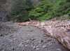
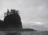
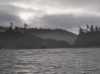
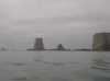
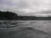
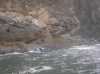
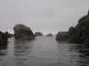
 Morning inside James Island at low tide
Links to related images: Nearby. Proofs. Map.
Approximate location: 47.9057006835938N / 124.648002624512W.
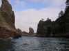
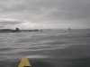
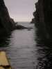
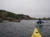
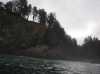 Paddling out of the knotch in James Island
Links to related images: Nearby. Proofs. Map.
Approximate location: 47.9059867858887N / 124.654312133789W.
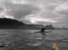
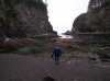
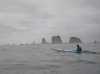
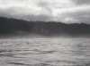
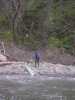
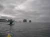 Roger Lamb paddling south from James Island
Links to related images: Nearby. Proofs. Map.
Approximate location: 47.8886985778809N / 124.638000488281W.

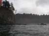
 Teahwhit Head
Links to related images: Nearby. Proofs. Map.
Approximate location: 47.874698638916N / 124.61799621582W.
 Roger Lamb approaching Teahwhit Head
Links to related images: Nearby. Proofs. Map.
Approximate location: 47.8726615905762N / 124.615173339844W.
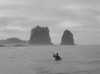
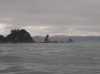
 Roger Lamb in front of the Giants Graveyard
Links to related images: Nearby. Proofs. Map.
Approximate location: 47.8548011779785N / 124.564002990723W.
 Rocky point south of La Push
Links to related images: Nearby. Proofs. Map.
Approximate location: 47.8535003662109N / 124.559997558594W.
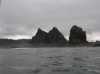
 Giants Graveyard
Links to related images: Nearby. Proofs. Map.
Approximate location: 47.8506011962891N / 124.559997558594W.
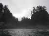
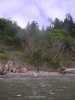
 Mist in the trees over a sandy beach
Links to related images: Nearby. Proofs. Map.
Approximate location: 47.8412017822266N / 124.551002502441W.
 Looking back throuh a rock garden
Links to related images: Nearby. Proofs. Map.
Approximate location: 47.8320999145508N / 124.541000366211W.
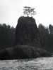 Another sea stack with a tree on top.
Links to related images: Nearby. Proofs. Map.
Approximate location: 47.8278999328613N / 124.524002075195W.
 Sandy beach past another rocky point
Links to related images: Nearby. Proofs. Map.
Approximate location: 47.8205986022949N / 124.514999389648W.
 Rock gardens leading up to Hoh Head
Links to related images: Nearby. Proofs. Map.
Approximate location: 47.8175010681152N / 124.511001586914W.
 Offshore rocks north of Hoh Head
Links to related images: Nearby. Proofs. Map.
Approximate location: 47.7970008850098N / 124.502998352051W.
 Roger Lamb rounding Hoh Head
Links to related images: Nearby. Proofs. Map.
Approximate location: 47.7666015625N / 124.480003356934W.
 Landed for lunch behind Hoh Head
Links to related images: Nearby. Proofs. Map.
Approximate location: 47.7676010131836N / 124.46900177002W.
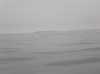 Destruction Island visible from Hoh Head
Links to related images: Nearby. Proofs. Map.
Approximate location: 47.7676010131836N / 124.46900177002W.
 Roger Lamb approaching Desctruction Island
Links to related images: Nearby. Proofs. Map.
Approximate location: 47.6781616210938N / 124.479667663574W.
 Rounding the east shore of Desctruction Island
Links to related images: Nearby. Proofs. Map.
Approximate location: 47.672779083252N / 124.482711791992W.
 First close-up view of the Desctruction Island lighthouse
Links to related images: Nearby. Proofs. Map.
Approximate location: 47.6721382141113N / 124.483871459961W.

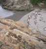
 Ruins of the Coast Guard dock on Desctruction Island
Links to related images: Nearby. Proofs. Map.
Approximate location: 47.6728286743164N / 124.484878540039W.
 The walkway from the Coast Guard dock on Desctruction Island
Links to related images: Nearby. Proofs. Map.
Approximate location: 47.672779083252N / 124.485527038574W.


 Rounding the south end of Desctruction Island
Links to related images: Nearby. Proofs. Map.
Approximate location: 47.6735000610352N / 124.488998413086W.
 The lighthouse and foghorn building on Desctruction Island
Links to related images: Nearby. Proofs. Map.
Approximate location: 47.6735000610352N / 124.488998413086W.

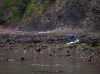
 Dead harbor seal in Desctruction Island cove
Links to related images: Nearby. Proofs. Map.
Approximate location: 47.6735000610352N / 124.488998413086W.


 Desctruction Island Lighthouse viewed from the south
Links to related images: Nearby. Proofs. Map.
Approximate location: 47.6735000610352N / 124.488998413086W.
 Worn rocks on south end of Desctruction Island
Links to related images: Nearby. Proofs. Map.
Approximate location: 47.6735000610352N / 124.488998413086W.

 Desctruction Island Lighthouse viewed from the south
Links to related images: Nearby. Proofs. Map.
Approximate location: 47.6735000610352N / 124.488998413086W.
 Roger Lamb returning to the Desctruction Island dock area
Links to related images: Nearby. Proofs. Map.
Approximate location: 47.6727294921875N / 124.486396789551W.
 Undermined foundation of the walkway from the Desctruction Island dock area
Links to related images: Nearby. Proofs. Map.
Approximate location: 47.6733016967773N / 124.486000061035W.
 Rocks and beaches around the Desctruction Island dock area
Links to related images: Nearby. Proofs. Map.
Approximate location: 47.6733016967773N / 124.486000061035W.

 Our camping beach in the Desctruction Island dock area
Links to related images: Nearby. Proofs. Map.
Approximate location: 47.6733016967773N / 124.486000061035W.

 The Desctruction Island dock area
Links to related images: Nearby. Proofs. Map.
Approximate location: 47.6733016967773N / 124.486000061035W.
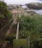
 The walkway from the Desctruction Island dock area
Links to related images: Nearby. Proofs. Map.
Approximate location: 47.6733016967773N / 124.486000061035W.


 Our camping beach viewed from the Desctruction Island walkway
Links to related images: Nearby. Proofs. Map.
Approximate location: 47.6733016967773N / 124.486000061035W.
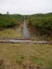
 Would you walk on this bridge? Could I resist?
Links to related images: Nearby. Proofs. Map.
Approximate location: 47.6733016967773N / 124.486000061035W.
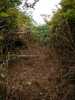
 Someone else has cleared the path to the Destruction Island Lighthouse
Links to related images: Nearby. Proofs. Map.
Approximate location: 47.6733016967773N / 124.486000061035W.
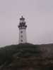
 The Destruction Island Lighthouse
Links to related images: Nearby. Proofs. Map.
Approximate location: 47.6744995117188N / 124.486000061035W.
 The Destruction Island solar cell array
Links to related images: Nearby. Proofs. Map.
Approximate location: 47.6744995117188N / 124.486000061035W.
 The Destruction Island fog horn buildings
Links to related images: Nearby. Proofs. Map.
Approximate location: 47.6744995117188N / 124.486000061035W.
 Who trims and fertilizes the lawns on Destruction Island?
Links to related images: Nearby. Proofs. Map.
Approximate location: 47.6770629882812N / 124.486167907715W.
 Railroad tracks and walkways criss-cross Destruction Island
Links to related images: Nearby. Proofs. Map.
Approximate location: 47.6744995117188N / 124.486000061035W.
 Base of the Destruction Island Lighthouse and keepers house
Links to related images: Nearby. Proofs. Map.
Approximate location: 47.6744995117188N / 124.486000061035W.
 The Destruction Island Lighthouse
Links to related images: Nearby. Proofs. Map.
Approximate location: 47.6744995117188N / 124.486000061035W.
 The Destruction Island fog horn building
Links to related images: Nearby. Proofs. Map.
Approximate location: 47.6744995117188N / 124.486000061035W.
 Manicured lawns behind the Destruction Island fog horn building
Links to related images: Nearby. Proofs. Map.
Approximate location: 47.6744995117188N / 124.486000061035W.
 The Destruction Island Lighthouse
Links to related images: Nearby. Proofs. Map.
Approximate location: 47.6744995117188N / 124.486000061035W.
 Destruction Island is criss-crossed with walkways
Links to related images: Nearby. Proofs. Map.
Approximate location: 47.6744995117188N / 124.486000061035W.
 Old concrete pad on Destruction Island
Links to related images: Nearby. Proofs. Map.
Approximate location: 47.6750984191895N / 124.484001159668W.
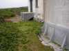
 Newer iron heli-pad on Destruction Island
Links to related images: Nearby. Proofs. Map.
Approximate location: 47.6750984191895N / 124.484001159668W.
 Pathway leading to rail tracks to no-where
Links to related images: Nearby. Proofs. Map.
Approximate location: 47.6750984191895N / 124.484001159668W.
 Lighthouse over the heli-pad
Links to related images: Nearby. Proofs. Map.
Approximate location: 47.6750984191895N / 124.484001159668W.

 Pathway leading to rail tracks to no-where
Links to related images: Nearby. Proofs. Map.
Approximate location: 47.6750984191895N / 124.484001159668W.
 Destruction Island is criss-crossed with walkways
Links to related images: Nearby. Proofs. Map.
Approximate location: 47.6750984191895N / 124.484001159668W.
 I finally caught a picture of the Desctruction Island Caretakers
Links to related images: Nearby. Proofs. Map.
Approximate location: 47.6750984191895N / 124.484001159668W.
 Roger Lamb exploring Desctruction Island
Links to related images: Nearby. Proofs. Map.
Approximate location: 47.6750984191895N / 124.484001159668W.

 Destruction Island has many old cisterns
Links to related images: Nearby. Proofs. Map.
Approximate location: 47.6750984191895N / 124.484001159668W.

 Ruins of older houses on Destruction Island
Links to related images: Nearby. Proofs. Map.
Approximate location: 47.6750984191895N / 124.484001159668W.
 Old piston head on Destruction Island
Links to related images: Nearby. Proofs. Map.
Approximate location: 47.6750984191895N / 124.484001159668W.
 Old spiral stair tred on Destruction Island
Links to related images: Nearby. Proofs. Map.
Approximate location: 47.6750984191895N / 124.484001159668W.
 Destruction Island Lighthouse
Links to related images: Nearby. Proofs. Map.
Approximate location: 47.6744995117188N / 124.486999511719W.
 Who trims and fertilizes the lawns on Destruction Island?
Links to related images: Nearby. Proofs. Map.
Approximate location: 47.6744995117188N / 124.486999511719W.
 Destruction Island is criss-crossed with walkways
Links to related images: Nearby. Proofs. Map.
Approximate location: 47.6744995117188N / 124.486999511719W.
 Destruction Island Lighthouse
Links to related images: Nearby. Proofs. Map.
Approximate location: 47.6744995117188N / 124.486999511719W.

 Destruction Island fog horn building
Links to related images: Nearby. Proofs. Map.
Approximate location: 47.6744995117188N / 124.486999511719W.
 The rugged west shore of Destruction Island
Links to related images: Nearby. Proofs. Map.
Approximate location: 47.6744995117188N / 124.486999511719W.

 Someone else has cleared the path to the Destruction Island Lighthouse
Links to related images: Nearby. Proofs. Map.
Approximate location: 47.6733016967773N / 124.485000610352W.

 Roger Lamb on the ruins of the Coast Guard Destruction Island Pier
Links to related images: Nearby. Proofs. Map.
Approximate location: 47.6733016967773N / 124.485000610352W.
 Fortunately, this warning sign was facing away from the sea and I could not read it
Links to related images: Nearby. Proofs. Map.
Approximate location: 47.6733016967773N / 124.485000610352W.
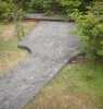
 The delapidated walkway from the pier to Destruction Island
Links to related images: Nearby. Proofs. Map.
Approximate location: 47.6733016967773N / 124.485000610352W.

 The landing cove on Destruction Island
Links to related images: Nearby. Proofs. Map.
Approximate location: 47.6733016967773N / 124.485000610352W.

 The delapidated walkway from the pier to Destruction Island
Links to related images: Nearby. Proofs. Map.
Approximate location: 47.6733016967773N / 124.485000610352W.
 Roger Lamb on the ruins of the Coast Guard Destruction Island Pier
Links to related images: Nearby. Proofs. Map.
Approximate location: 47.6733016967773N / 124.485000610352W.
 View over the ruins of the Destruction Island pier to the mainland and south
Links to related images: Nearby. Proofs. Map.
Approximate location: 47.6733016967773N / 124.485000610352W.

 The ruins of the Coast Guard Pier on Destruction Island
Links to related images: Nearby. Proofs. Map.
Approximate location: 47.6733016967773N / 124.485000610352W.
 The landing cove on Destruction Island
Links to related images: Nearby. Proofs. Map.
Approximate location: 47.6733016967773N / 124.485000610352W.


 Our camping beach on Destruction Island
Links to related images: Nearby. Proofs. Map.
Approximate location: 47.6733016967773N / 124.485000610352W.
 Name the knot used to toss a line through a treebranch
Links to related images: Nearby. Proofs. Map.
Approximate location: 47.6733016967773N / 124.485000610352W.
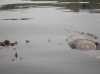
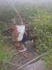
 Sick bird at the tideline on Destruction Island
Links to related images: Nearby. Proofs. Map.
Approximate location: 47.6730995178223N / 124.486000061035W.
All text and images Copyright © 2006 by Mike Higgins / contact