Ozette Island to James Island, August 9th 2006.
Click on the small image to see the full-sized one.


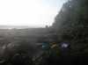
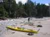
 Our camp on Ozette Island
Links to related images: Nearby. Proofs. Map.
Approximate location: 48.1577987670898N / 124.749000549316W.
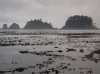
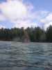
 Low tide on Ozette Island almost goes to the mainland
Links to related images: Nearby. Proofs. Map.
Approximate location: 48.1577987670898N / 124.749000549316W.

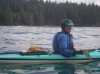
 Roger Lamb and I find a short path to water
Links to related images: Nearby. Proofs. Map.
Approximate location: 48.1577987670898N / 124.749000549316W.
 Looking over the long path to water
Links to related images: Nearby. Proofs. Map.
Approximate location: 48.1587562561035N / 124.749496459961W.


 Roger Lamb taking the short path to water
Links to related images: Nearby. Proofs. Map.
Approximate location: 48.1587562561035N / 124.749496459961W.
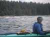
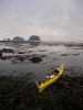 My boat ready to launch from Ozette Island
Links to related images: Nearby. Proofs. Map.
Approximate location: 48.1587562561035N / 124.749496459961W.
 Rocks north of Ozette Island
Links to related images: Nearby. Proofs. Map.
Approximate location: 48.1621932983398N / 124.751472473145W.

 The north end of Ozette Island in the morning
Links to related images: Nearby. Proofs. Map.
Approximate location: 48.1586418151855N / 124.755851745605W.
 The rugged southwest side of Ozette Island
Links to related images: Nearby. Proofs. Map.
Approximate location: 48.1543502807617N / 124.748725891113W.

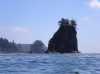
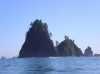
 Sea Stack south of Ozette Island
Links to related images: Nearby. Proofs. Map.
Approximate location: 48.1372833251953N / 124.734222412109W.
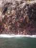 Sea Stars on a Sea Stack south of Ozette Island
Links to related images: Nearby. Proofs. Map.
Approximate location: 48.1352767944336N / 124.732246398926W.
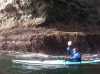 Roger Lamb in front of a Sea Stack south of Ozette Island
Links to related images: Nearby. Proofs. Map.
Approximate location: 48.1352767944336N / 124.732246398926W.
 Close up of a Sea Stack south of Ozette Island
Links to related images: Nearby. Proofs. Map.
Approximate location: 48.1350479125977N / 124.731819152832W.
 Looking north over the shallows off Sand Point
Links to related images: Nearby. Proofs. Map.
Approximate location: 48.1230163574219N / 124.721000671387W.
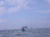
 Roger Lamb paddling around Sand Point
Links to related images: Nearby. Proofs. Map.
Approximate location: 48.1202659606934N / 124.716026306152W.
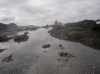
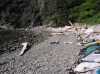
 Looking at the beaches below Sand Point
Links to related images: Nearby. Proofs. Map.
Approximate location: 48.1043930053711N / 124.703750610352W.
 Calm water back to Ozette Island
Links to related images: Nearby. Proofs. Map.
Approximate location: 48.1031341552734N / 124.702980041504W.
 Calm water behind rock garden to land for lunch
Links to related images: Nearby. Proofs. Map.
Approximate location: 48.0544471740723N / 124.688819885254W.
 Roger Lamb landed for lunch
Links to related images: Nearby. Proofs. Map.
Approximate location: 48.0544471740723N / 124.688819885254W.
 Roger Lamb launched after lunch
Links to related images: Nearby. Proofs. Map.
Approximate location: 48.0546760559082N / 124.692680358887W.
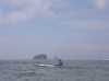
 Roger Lamb passing by Carrol Island
Links to related images: Nearby. Proofs. Map.
Approximate location: 47.9969863891602N / 124.687782287598W.

 Passing by Cape Johnson
Links to related images: Nearby. Proofs. Map.
Approximate location: 47.9679145812988N / 124.685035705566W.
 Roger Lamb and I landed to filter water from a creek
Links to related images: Nearby. Proofs. Map.
Approximate location: 47.9329071044922N / 124.643409729004W.
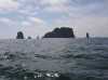
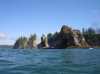
 More sea stacks with trees
Links to related images: Nearby. Proofs. Map.
Approximate location: 47.9385414123535N / 124.667785644531W.
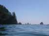
 More offshore islands we did not have time to explore
Links to related images: Nearby. Proofs. Map.
Approximate location: 47.9373931884766N / 124.664695739746W.
 More trees on sea stacks
Links to related images: Nearby. Proofs. Map.
Approximate location: 47.9376792907715N / 124.667877197266W.

 Rocks past Cape Johnson
Links to related images: Nearby. Proofs. Map.
Approximate location: 47.9084014892578N / 124.655082702637W.
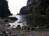

 Landed inside the lagoon in James Island
Links to related images: Nearby. Proofs. Map.
Approximate location: 47.9057579040527N / 124.648391723633W.
 A piece of flotsam, old glory in a drink bottle
Links to related images: Nearby. Proofs. Map.
Approximate location: 47.9057579040527N / 124.648391723633W.


 Sunset out the gap in James Island
Links to related images: Nearby. Proofs. Map.
Approximate location: 47.9057579040527N / 124.648391723633W.
All text and images Copyright © 2006 by Mike Higgins / contact