Point Lobos, March 26th 2005.
Click on the small image to see the full-sized one.
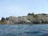
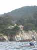
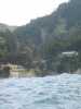
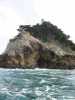
 The green north side of Point Lobos
Links to related images: Nearby. Proofs. Map.
Approximate location: 36.5243606567383N / 121.943908691406W.
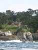
 Looking in at Bluefish Cove Point Lobos
Links to related images: Nearby. Proofs. Map.
Approximate location: 36.5243606567383N / 121.943908691406W.
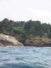
 The green north side of Point Lobos
Links to related images: Nearby. Proofs. Map.
Approximate location: 36.5243606567383N / 121.943908691406W.
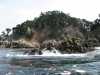
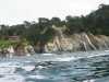
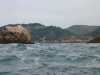
 Rugged north side of Point Lobos
Links to related images: Nearby. Proofs. Map.
Approximate location: 36.5243606567383N / 121.943908691406W.
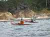
 Joe Petolino and Jack Pines near Point Lobos
Links to related images: Nearby. Proofs. Map.
Approximate location: 36.5243606567383N / 121.943908691406W.
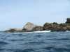
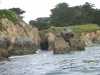
 Rugged north side of Point Lobos
Links to related images: Nearby. Proofs. Map.
Approximate location: 36.5243606567383N / 121.943908691406W.
 Jack Pines and Joe Petolino near Point Lobos
Links to related images: Nearby. Proofs. Map.
Approximate location: 36.5243606567383N / 121.943908691406W.

 Pinnacle Point on Point Lobos
Links to related images: Nearby. Proofs. Map.
Approximate location: 36.5243606567383N / 121.943908691406W.
 Joe Petolino and Jack Pines at Pinnacle Point
Links to related images: Nearby. Proofs. Map.
Approximate location: 36.5243606567383N / 121.943908691406W.
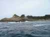
 Narrow cove on south side of Point Lobos
Links to related images: Nearby. Proofs. Map.
Approximate location: 36.5189514160156N / 121.955146789551W.
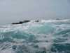 Rough water over Seal Rocks at Devils Cauldron Point Lobos
Links to related images: Nearby. Proofs. Map.
Approximate location: 36.5189514160156N / 121.955146789551W.
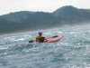
 Joe Petolino paddling south from Point Lobos towards Carmel Highlands
Links to related images: Nearby. Proofs. Map.
Approximate location: 36.5189514160156N / 121.955146789551W.
 Jack Pines paddling south from Point Lobos towards Carmel Highlands
Links to related images: Nearby. Proofs. Map.
Approximate location: 36.5189514160156N / 121.955146789551W.
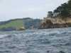
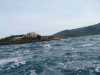 Bird Rock at Point Lobos from a distance
Links to related images: Nearby. Proofs. Map.
Approximate location: 36.4965286254883N / 121.941352844238W.
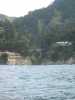
 Super Mansions of the Super Rich at the shore of Carmel Highlands
Links to related images: Nearby. Proofs. Map.
Approximate location: 36.4965286254883N / 121.941352844238W.
 Jack Pines at Carmel Highlands
Links to related images: Nearby. Proofs. Map.
Approximate location: 36.4965286254883N / 121.941352844238W.
 Approaching Yankee Point
Links to related images: Nearby. Proofs. Map.
Approximate location: 36.4965286254883N / 121.941352844238W.

 Super Mansions of the Super Rich at the shore of Carmel Highlands
Links to related images: Nearby. Proofs. Map.
Approximate location: 36.4965286254883N / 121.941352844238W.
 The south tip of Yankee Point
Links to related images: Nearby. Proofs. Map.
Approximate location: 36.4887809753418N / 121.942977905273W.
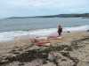
 The beach inside Yankee Point
Links to related images: Nearby. Proofs. Map.
Approximate location: 36.4887809753418N / 121.942977905273W.

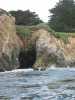 A cave inside Yankee Point
Links to related images: Nearby. Proofs. Map.
Approximate location: 36.4887809753418N / 121.942977905273W.
 Jack Pines and Joe Petolino landing for lunch at Yankee Point
Links to related images: Nearby. Proofs. Map.
Approximate location: 36.4887809753418N / 121.942977905273W.

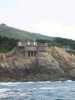
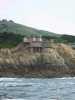
 Views of the Montastery as we paddled back from Point Lobos
Links to related images: Nearby. Proofs. Map.
Approximate location: 36.5239410400391N / 121.937782287598W.
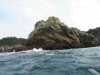
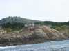
 Granite rocks off Granite Point
Links to related images: Nearby. Proofs. Map.
Approximate location: 36.5239410400391N / 121.937782287598W.
 Views of the Montastery as we paddled back from Point Lobos
Links to related images: Nearby. Proofs. Map.
Approximate location: 36.5239410400391N / 121.937782287598W.
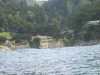
 Jack Pines safely landed at Montastery Beach
Links to related images: Nearby. Proofs. Map.
Approximate location: 36.5243797302246N / 121.92626953125W.


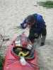
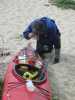 Joe Petolino photographing sand on the deck of his kayak
Links to related images: Nearby. Proofs. Map.
Approximate location: 36.5243797302246N / 121.92626953125W.
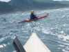
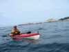
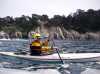 The intrepid kayaker paddling around Point Lobos
Links to related images: Nearby. Proofs. Map.
Approximate location: 36.5021781921387N / 121.941757202148W.
All text and images Copyright © 2005 by Mike Higgins / contact