Jamala to Gaviota Beach, September 5th 2004.
Click on the small image to see the full-sized one.
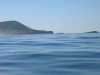
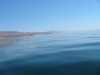
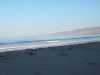 Morning sunlight on the waves
at Jamala Beach
Morning sunlight on the waves
at Jamala Beach
Links to related images: Nearby. Proofs. Map.
Approximate location: 34.5150337219238N / 120.505264282227W.
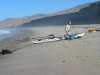
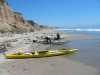
 John and Fred packing in the morning
at Jamala Beach
John and Fred packing in the morning
at Jamala Beach
Links to related images: Nearby. Proofs. Map.
Approximate location: 34.5150337219238N / 120.505264282227W.
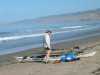 John Somers packing his kayak at Jamala Beach
Links to related images: Nearby. Proofs. Map.
Approximate location: 34.5150337219238N / 120.505264282227W.
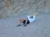 Fred Cooper waiting for John to get ready at Jamala Beach
Links to related images: Nearby. Proofs. Map.
Approximate location: 34.5150337219238N / 120.505264282227W.


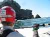
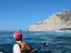
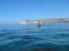
 Approaching from the north
at Point Conception
Approaching from the north
at Point Conception
Links to related images: Nearby. Proofs. Map.
Approximate location: 34.4511222839355N / 120.472885131836W.
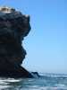
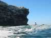
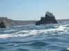
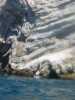
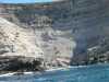
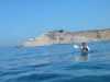
 Close up of cliff
at Point Conception
Close up of cliff
at Point Conception
Links to related images: Nearby. Proofs. Map.
Approximate location: 34.4494476318359N / 120.471984863281W.

 John Somers in front of cliff at Point Conception
Links to related images: Nearby. Proofs. Map.
Approximate location: 34.4496955871582N / 120.47176361084W.
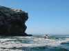
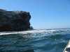
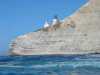
 Close up of cliff
at Point Conception
Close up of cliff
at Point Conception
Links to related images: Nearby. Proofs. Map.
Approximate location: 34.4495735168457N / 120.471725463867W.
 Fred Cooper approaching cliff at Point Conception
Links to related images: Nearby. Proofs. Map.
Approximate location: 34.4494934082031N / 120.472038269043W.
 Me in front of cliff
at Point Conception
Me in front of cliff
at Point Conception
Links to related images: Nearby. Proofs. Map.
Approximate location: 34.4495658874512N / 120.471527099609W.
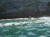
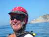
 The intrepid kayaker in front of Point Conception
Links to related images: Nearby. Proofs. Map.
Approximate location: 34.4493865966797N / 120.471961975098W.
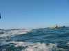
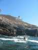
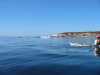
 Starting around the corner
at Point Conception
Starting around the corner
at Point Conception
Links to related images: Nearby. Proofs. Map.
Approximate location: 34.4491386413574N / 120.472236633301W.
 John Somers points to the route throgh the rocks at Point Conception
Links to related images: Nearby. Proofs. Map.
Approximate location: 34.4487609863281N / 120.47225189209W.
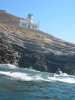
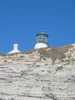
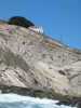
 The lighthouse
at Point Conception
The lighthouse
at Point Conception
Links to related images: Nearby. Proofs. Map.
Approximate location: 34.4481506347656N / 120.471382141113W.
 John Somers behind the point at Point Conception
Links to related images: Nearby. Proofs. Map.
Approximate location: 34.4482727050781N / 120.471084594727W.
 Looking west
at Point Conception
Looking west
at Point Conception
Links to related images: Nearby. Proofs. Map.
Approximate location: 34.4483070373535N / 120.469573974609W.
 John behind the lighthouse
at Point Conception
John behind the lighthouse
at Point Conception
Links to related images: Nearby. Proofs. Map.
Approximate location: 34.4486351013184N / 120.469505310059W.
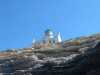
 Looking up at the lighthouse
at Point Conception
Looking up at the lighthouse
at Point Conception
Links to related images: Nearby. Proofs. Map.
Approximate location: 34.448802947998N / 120.469688415527W.
 John behind the point
at Point Conception
John behind the point
at Point Conception
Links to related images: Nearby. Proofs. Map.
Approximate location: 34.448802947998N / 120.469688415527W.
 Looking up at the lighthouse
at Point Conception
Looking up at the lighthouse
at Point Conception
Links to related images: Nearby. Proofs. Map.
Approximate location: 34.448802947998N / 120.469688415527W.

 Cliff behind the point
at Point Conception
Cliff behind the point
at Point Conception
Links to related images: Nearby. Proofs. Map.
Approximate location: 34.448802947998N / 120.469688415527W.
 John Somers looking back at the lighthouse at Point Conception
Links to related images: Nearby. Proofs. Map.
Approximate location: 34.4483604431152N / 120.468414306641W.
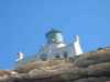
 Lighthouse keepers house
at Point Conception
Lighthouse keepers house
at Point Conception
Links to related images: Nearby. Proofs. Map.
Approximate location: 34.4483604431152N / 120.468414306641W.
 Looking back at the lighthouse
at Point Conception
Looking back at the lighthouse
at Point Conception
Links to related images: Nearby. Proofs. Map.
Approximate location: 34.4483604431152N / 120.468414306641W.
 Lighthouse keepers house
at Point Conception
Lighthouse keepers house
at Point Conception
Links to related images: Nearby. Proofs. Map.
Approximate location: 34.4483604431152N / 120.468414306641W.
 Looking back at the lighthouse
at Point Conception
Looking back at the lighthouse
at Point Conception
Links to related images: Nearby. Proofs. Map.
Approximate location: 34.4481506347656N / 120.467155456543W.
 Fred Cooper in front of lighthouse and kepers house at Point Conception
Links to related images: Nearby. Proofs. Map.
Approximate location: 34.4478645324707N / 120.466125488281W.
 John in front of cliff
at Point Conception
John in front of cliff
at Point Conception
Links to related images: Nearby. Proofs. Map.
Approximate location: 34.4460334777832N / 120.461196899414W.
 Fred Cooper up close with lighthouse behind at Point Conception
Links to related images: Nearby. Proofs. Map.
Approximate location: 34.4460334777832N / 120.461196899414W.
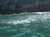
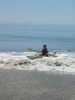
 Nice surfing wave
at Government Point
Nice surfing wave
at Government Point
Links to related images: Nearby. Proofs. Map.
Approximate location: 34.4440078735352N / 120.447708129883W.
 Looking east
at Government Point
Looking east
at Government Point
Links to related images: Nearby. Proofs. Map.
Approximate location: 34.4440078735352N / 120.447708129883W.
 Fred Cooper landing at Holister Ranch
Links to related images: Nearby. Proofs. Map.
Approximate location: 34.456901550293N / 120.356002807617W.
 John and Fred unpacking
at Holister Ranch
John and Fred unpacking
at Holister Ranch
Links to related images: Nearby. Proofs. Map.
Approximate location: 34.4569206237793N / 120.355751037598W.
 John and Fred packing
at Holister Ranch
John and Fred packing
at Holister Ranch
Links to related images: Nearby. Proofs. Map.
Approximate location: 34.4569206237793N / 120.355751037598W.
 Fred paddling east
at Holister Ranch
Fred paddling east
at Holister Ranch
Links to related images: Nearby. Proofs. Map.
Approximate location: 34.4558296203613N / 120.351623535156W.
 John paddling east
at Holister Ranch
John paddling east
at Holister Ranch
Links to related images: Nearby. Proofs. Map.
Approximate location: 34.4558296203613N / 120.351623535156W.
 SUVs driving on the beach
at Holister Ranch
SUVs driving on the beach
at Holister Ranch
Links to related images: Nearby. Proofs. Map.
Approximate location: 34.4563217163086N / 120.340202331543W.
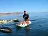 Mark on his waveski
at Holister Ranch
Mark on his waveski
at Holister Ranch
Links to related images: Nearby. Proofs. Map.
Approximate location: 34.4571723937988N / 120.339775085449W.
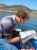 Phil studying our maps from his surfboard
at Holister Ranch
Phil studying our maps from his surfboard
at Holister Ranch
Links to related images: Nearby. Proofs. Map.
Approximate location: 34.4571723937988N / 120.339775085449W.
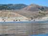
 Memorial day weekend crowd
at Gaviota Beach
Memorial day weekend crowd
at Gaviota Beach
Links to related images: Nearby. Proofs. Map.
Approximate location: 34.4697685241699N / 120.228370666504W.
All text and images Copyright © 2004 by Mike Higgins / contact