Miller Park to Estero de San Antonio, April 7th 2002.
Click on the small image to see the full-sized one.
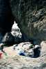 Don Fleming napping near arch at the mouth of Estero de San Antonio
Links to related images: Nearby. Proofs. Map.
Approximate location: 38.2705001831055N / 122.978996276855W.
 Kayaks landed at the mouth of Estero de San Antonio
Links to related images: Nearby. Proofs. Map.
Approximate location: 38.2705001831055N / 122.978996276855W.
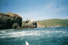
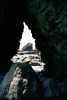 Arch at the mouth of Estero de San Antonio
Links to related images: Nearby. Proofs. Map.
Approximate location: 38.2705001831055N / 122.978996276855W.
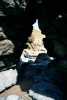 Don Fleming napping at the mouth of Estero de San Antonio
Links to related images: Nearby. Proofs. Map.
Approximate location: 38.2705001831055N / 122.978996276855W.
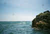
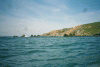
 Kayaks rounding the point into Tomales Bay
Links to related images: Nearby. Proofs. Map.
Approximate location: 38.2294998168945N / 122.978996276855W.
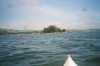
 Approaching Hog Island in Tomales Bay
Links to related images: Nearby. Proofs. Map.
Approximate location: 38.1985015869141N / 122.938003540039W.
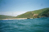
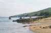
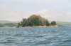
 Shoreline near Estero de San Antonio
Links to related images: Nearby. Proofs. Map.
Approximate location: 38.2704010009766N / 122.981002807617W.
All text and images Copyright © 2002 by Mike Higgins / contact