Baja, Layover day at Punta San Juan Bautista, March 28th 2002.
Click on the small image to see the full-sized one.
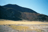
 Morning at Bahia San Juan Bautista
Links to related images: Nearby. Map.
Approximate location: 28.0215301513672N / 112.803497314453W.
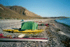
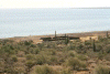
 John's tent at Bahia San Juan Bautista
Links to related images: Nearby. Map.
Approximate location: 28.0215301513672N / 112.803497314453W.
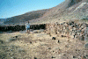 Stone corral at Bahia San Juan Bautista
Links to related images: Nearby. Map.
Approximate location: 28.0236511230469N / 112.803924560547W.
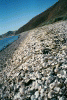
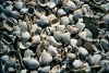 Berm of shells at Bahia San Juan Bautista
Links to related images: Nearby. Map.
Approximate location: 28.0236511230469N / 112.803924560547W.
 Stone corral from above.
Links to related images: Nearby. Map.
Approximate location: 28.022590637207N / 112.806503295898W.
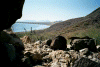 Bahia San Juan Bautista from a cave in the hills
Links to related images: Nearby. Map.
Approximate location: 28.022970199585N / 112.807792663574W.
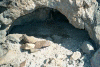 Cave in the hills at Bahia San Juan Bautista
Links to related images: Nearby. Map.
Approximate location: 28.022970199585N / 112.807792663574W.
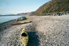
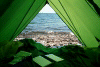 The view out my tent at Bahia San Juan Bautista
Links to related images: Nearby. Map.
Approximate location: 28.0213794708252N / 112.803329467773W.
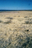
 Field of dry grass at Bahia San Juan Bautista
Links to related images: Nearby. Map.
Approximate location: 28.0157718658447N / 112.80152130127W.
 Bahia San Juan Bautista beach from the south
Links to related images: Nearby. Map.
Approximate location: 28.0172119140625N / 112.801010131836W.
All text and images Copyright © 2002 by Mike Higgins / contact