Davenport Landing to Santa Cruz, August 8th 2001.
Click on the small image to see the full-sized one.
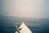 Into the fog off Davenport Landing
Links to related images: Nearby. Proofs. Map.
Approximate location: 37.0240058898926N / 122.217407226562W.
 abandoned Davenport pier in fog
Links to related images: Nearby. Proofs. Map.
Approximate location: 37.0198936462402N / 122.217582702637W.
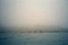
 Sid and Konstantin camped here?
Links to related images: Nearby. Proofs. Map.
Approximate location: 37.0068702697754N / 122.194488525391W.
 Limestone caves
Links to related images: Nearby. Proofs. Map.
Approximate location: 37.0036506652832N / 122.188568115234W.
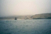
 rough cove, I stayed out
Links to related images: Nearby. Proofs. Map.
Approximate location: 37.0022773742676N / 122.186935424805W.

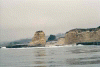
 table rock, fuzzy picture
Links to related images: Nearby. Proofs. Map.
Approximate location: 36.9744453430176N / 122.154235839844W.
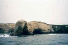
 limestone cliffs, fuzzy
Links to related images: Nearby. Proofs. Map.
Approximate location: 36.9744453430176N / 122.149253845215W.

 Limestone cliffs, caves
Links to related images: Nearby. Proofs. Map.
Approximate location: 36.9744453430176N / 122.149253845215W.
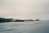 Table rock distant
Links to related images: Nearby. Proofs. Map.
Approximate location: 36.9659423828125N / 122.134841918945W.
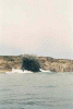 needle rock
Links to related images: Nearby. Proofs. Map.
Approximate location: 36.9617500305176N / 122.118789672852W.
 Natural Bridge State Park
Links to related images: Nearby. Proofs. Map.
Approximate location: 36.9488716125488N / 122.057914733887W.
 Steamers Lane surf Museum
Links to related images: Nearby. Proofs. Map.
Approximate location: 36.9507904052734N / 122.027702331543W.
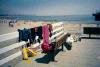 Gear drying on the Santa Cruz Pier
Links to related images: Nearby. Proofs. Map.
Approximate location: 36.9625358581543N / 122.023612976074W.
All text and images Copyright © 2001 by Mike Higgins / contact