Seal Rock to Pigeon Point, August 6th 2001.
Click on the small image to see the full-sized one.
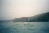
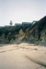
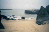 Landing spot at low tide in the morning
Links to related images: Nearby. Proofs. Map.
Approximate location: 37.3932609558105N / 122.422691345215W.
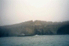
 I'd rather launch here
Links to related images: Nearby. Proofs. Map.
Approximate location: 37.3933296203613N / 122.422561645508W.
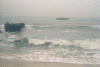
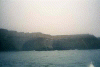
 Boat loaded and ready to fly down berm
Links to related images: Nearby. Proofs. Map.
Approximate location: 37.3936347961426N / 122.422431945801W.
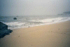
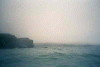
 Waves to launch over
Links to related images: Nearby. Proofs. Map.
Approximate location: 37.393497467041N / 122.422523498535W.
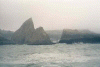 Martin's beach through rocks
Links to related images: Nearby. Proofs. Map.
Approximate location: 37.3763885498047N / 122.41170501709W.
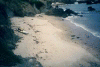
 Martin's Beach closer
Links to related images: Nearby. Proofs. Map.
Approximate location: 37.3745307922363N / 122.410011291504W.
 Limestone clifs and caves, panorama 1/4
Links to related images: Nearby. Proofs. Map.
Approximate location: 37.2896995544434N / 122.410003662109W.
 Limestone clifs and caves, panorama 2/4
Links to related images: Nearby. Proofs. Map.
Approximate location: 37.2896995544434N / 122.410003662109W.
 Limestone clifs and caves, panorama 3/4
Links to related images: Nearby. Proofs. Map.
Approximate location: 37.2896995544434N / 122.410003662109W.
 Limestone clifs and caves, panorama 4/4
Links to related images: Nearby. Proofs. Map.
Approximate location: 37.2896995544434N / 122.410003662109W.
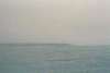 Pigeon Point Lighthouse, distant
Links to related images: Nearby. Proofs. Map.
Approximate location: 37.2042198181152N / 122.413360595703W.
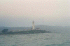

 Pigeon Point Lighthouse, closer
Links to related images: Nearby. Proofs. Map.
Approximate location: 37.1810913085938N / 122.393669128418W.
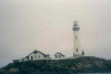
 Pigeon Point Lighthouse, very close
Links to related images: Nearby. Proofs. Map.
Approximate location: 37.1813735961914N / 122.392692565918W.
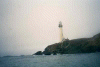 Pigeon Point Lighthouse from behind
Links to related images: Nearby. Proofs. Map.
Approximate location: 37.1820640563965N / 122.391899108887W.
 Whalers cove where I will land
Links to related images: Nearby. Proofs. Map.
Approximate location: 37.1820640563965N / 122.391899108887W.
 kayak at the top of whalers cove
Links to related images: Nearby. Proofs. Map.
Approximate location: 37.1825180053711N / 122.39274597168W.
 View down into crack in the rocks
Links to related images: Nearby. Proofs. Map.
Approximate location: 37.1816711425781N / 122.394500732422W.
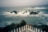 Reef off Pigeon Point
Links to related images: Nearby. Proofs. Map.
Approximate location: 37.1819038391113N / 122.394462585449W.
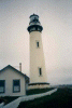 Lighthouse from the land.
Links to related images: Nearby. Proofs. Map.
Approximate location: 37.181827545166N / 122.393989562988W.
All text and images Copyright © 2001 by Mike Higgins / contact