Humboldt County, Cape Mendocino, August 14th, 2000.
Click on the small image to see the full-sized one.
 On a walk around the point I see Seamboat rock, California sea lions and the li
Links to related images: Nearby. Proofs. Map.
Approximate location: 40.439826965332N / 124.4091796875W.
 Looking up at the lighthouse from the beach
Links to related images: Nearby. Proofs. Map.
Approximate location: 40.4394683837891N / 124.409309387207W.
 Sugarloaf Island viewed from shore by morning light.
Links to related images: Nearby. Proofs. Map.
Approximate location: 40.4385223388672N / 124.409690856934W.

 The view from the lighthouse the next morning, the brown line along shore is 10
Links to related images: Nearby. Proofs. Map.
Approximate location: 40.4384536743164N / 124.40601348877W.

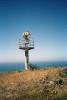
 I climbed to see the lighthouse, but only find the old foundation. What happene
Links to related images: Nearby. Proofs. Map.
Approximate location: 40.4401473999023N / 124.406776428223W.
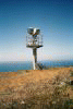
 A new rotating flasher replaced the old lighthouse.
Links to related images: Nearby. Proofs. Map.
Approximate location: 40.4398994445801N / 124.40608215332W.
 A view of the angry sea ahead to Punta Gorda. I spent a day here waiting for th
Links to related images: Nearby. Proofs. Map.
Approximate location: 40.4398994445801N / 124.40608215332W.
 Out of focus sunset
Links to related images: Nearby. Proofs. Map.
Approximate location: 40.4345932006836N / 124.405166625977W.

 Sunset next to Sugarloaf Island.
Links to related images: Nearby. Proofs. Map.
Approximate location: 40.4345932006836N / 124.405166625977W.
 Sunset next to Sugarloaf Island
Links to related images: Nearby. Proofs. Map.
Approximate location: 40.4345932006836N / 124.405166625977W.
All text and images Copyright © 2000 by Mike Higgins / contact