Humboldt County, Freshwater Lagoon to Trinidad, August 10th and 11th, 2000.
Click on the small image to see the full-sized one.
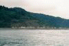
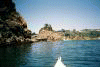
 The Redwood National Park Visitors Center viewed from the water.
Links to related images: Nearby. Proofs. Map.
Approximate location: 41.287353515625N / 124.095809936523W.
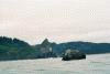
 RVs parked for free on the beach at Freshwater Lagoon.
Links to related images: Nearby. Proofs. Map.
Approximate location: 41.2718086242676N / 124.100402832031W.
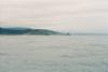
 Sharp Point south of Freshwater and Stone Lagoon.
Links to related images: Nearby. Proofs. Map.
Approximate location: 41.2664527893066N / 124.101303100586W.


 Approaching Patrick's Point the shore looks interesting and rocky.
Links to related images: Nearby. Proofs. Map.
Approximate location: 41.1394920349121N / 124.166275024414W.


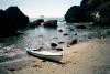
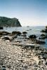 I land on a cobble beach for lunch on Patrick's Point.
Links to related images: Nearby. Proofs. Map.
Approximate location: 41.0903472900391N / 124.156837463379W.


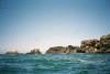
 Offshore rocks
Links to related images: Nearby. Proofs. Map.
Approximate location: 41.086856842041N / 124.157012939453W.
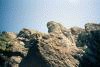
 Grass covered knob of rock
Links to related images: Nearby. Proofs. Map.
Approximate location: 41.0834922790527N / 124.158210754395W.
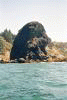 Black rock on shore
Links to related images: Nearby. Proofs. Map.
Approximate location: 41.0807762145996N / 124.156661987305W.
 Looking back at rocky point
Links to related images: Nearby. Proofs. Map.
Approximate location: 41.0807762145996N / 124.156661987305W.
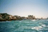 First view of Trinidad State Beach.
Links to related images: Nearby. Proofs. Map.
Approximate location: 41.0683517456055N / 124.158897399902W.


 Trinidad State Beach looks like a nice place for a day paddle.
Links to related images: Nearby. Proofs. Map.
Approximate location: 41.0609741210938N / 124.152030944824W.


 Trinidad Head is a monolith of stone.
Links to related images: Nearby. Proofs. Map.
Approximate location: 41.0516471862793N / 124.151573181152W.
 Rounding Trinidad Head to land in front of the town.
Links to related images: Nearby. Proofs. Map.
Approximate location: 41.0507965087891N / 124.149421691895W.
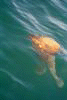 The water is full of orange jellyfish.
Links to related images: Nearby. Proofs. Map.
Approximate location: 41.0512161254883N / 124.148918151855W.
 Rounding Trinidad Head to land in front of the town.
Links to related images: Nearby. Proofs. Map.
Approximate location: 41.0564842224121N / 124.147514343262W.


 Paddling around the inside of the protected bay.
Links to related images: Nearby. Proofs. Map.
Approximate location: 41.0555381774902N / 124.139717102051W.

 The beach I chose to camp on for the night.
Links to related images: Nearby. Proofs. Map.
Approximate location: 41.0465393066406N / 124.124092102051W.

 The beach I chose to camp on for the night.
Links to related images: Nearby. Proofs. Map.
Approximate location: 41.046558380127N / 124.124198913574W.
All text and images Copyright © 2000 by Mike Higgins / contact