Angel Island Campout of the Century, December 31st 1999 to January 2nd.
Click on the small image to see the full-sized one.
 Maryly Snow in her new tent on Angel Island
Links to related images: Nearby. Proofs. Map.
Approximate location: 37.8574981689453N / 122.440002441406W.
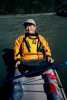
 The intrepid kayaker outside a tent on Angel Island
Links to related images: Nearby. Proofs. Map.
Approximate location: 37.857479095459N / 122.439796447754W.
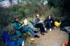 BASKers basking in Ridge Camp on Angel Island
Links to related images: Nearby. Proofs. Map.
Approximate location: 37.857479095459N / 122.439796447754W.
 Maryly Snow enjoying dinner in Ridge Camp on Angel Island
Links to related images: Nearby. Proofs. Map.
Approximate location: 37.857479095459N / 122.439796447754W.
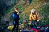
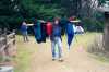 Lugging kayak gear up to Ridge Camp on Angel Island
Links to related images: Nearby. Proofs. Map.
Approximate location: 37.857479095459N / 122.439796447754W.
 Unused Kayak Camp on Angel Island
Links to related images: Nearby. Proofs. Map.
Approximate location: 37.857479095459N / 122.439796447754W.
 Photographer near Ridge Camp on Angel Island
Links to related images: Nearby. Proofs. Map.
Approximate location: 37.857479095459N / 122.439796447754W.
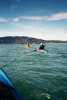
 Kayakers resting on Perls Beach on Angel Island
Links to related images: Nearby. Proofs. Map.
Approximate location: 37.857479095459N / 122.439796447754W.
 Photographing tourists at Dumphy Park on the way to Angel Island
Links to related images: Nearby. Proofs. Map.
Approximate location: 37.857479095459N / 122.439796447754W.
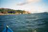
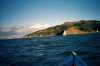
 Approaching Angel Island
Links to related images: Nearby. Proofs. Map.
Approximate location: 37.857479095459N / 122.439796447754W.
 Landed on Perls Beach on Angel Island
Links to related images: Nearby. Proofs. Map.
Approximate location: 37.857479095459N / 122.439796447754W.
 Maryly Snow with electric toothbrush on Angel Island
Links to related images: Nearby. Proofs. Map.
Approximate location: 37.857479095459N / 122.439796447754W.
 Maryly Snow ready to leave Angel Island
Links to related images: Nearby. Proofs. Map.
Approximate location: 37.857479095459N / 122.439796447754W.
 Heading back to Marin from Angel Island
Links to related images: Nearby. Proofs. Map.
Approximate location: 37.857479095459N / 122.439796447754W.
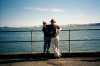 Maryly Snow and Mike Higgins safely back from Angel Island
Links to related images: Nearby. Proofs. Map.
Approximate location: 37.857479095459N / 122.439796447754W.
All text and images Copyright © 1999 by Mike Higgins / contact