Redwood Hostel to Gold Bluff Beach. Friday August 13th 1999.
Click on the small image to see the full-sized one.
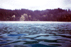
 Del Norte, false Klamath Rock.
Links to related images: Nearby. Proofs. Map.
Approximate location: 41.5958023071289N / 124.11156463623W.
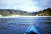
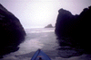 Del Norte, going behind the rocks
Links to related images: Nearby. Proofs. Map.
Approximate location: 41.5777816772461N / 124.101402282715W.
 Del Norte, beautiful offshore rock with tree
Links to related images: Nearby. Proofs. Map.
Approximate location: 41.5730056762695N / 124.103721618652W.
 Del Norte, point with cave?
Links to related images: Nearby. Proofs. Map.
Approximate location: 41.5663681030273N / 124.101135253906W.
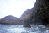
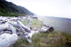
 Del Norte, nice view of rocky shore
Links to related images: Nearby. Proofs. Map.
Approximate location: 41.5590782165527N / 124.097686767578W.
 Del Norte, folded layers in the rock
Links to related images: Nearby. Proofs. Map.
Approximate location: 41.5190010070801N / 124.083000183105W.
 Del Norte, arch leading out, water on lens!
Links to related images: Nearby. Proofs. Map.
Approximate location: 41.5190010070801N / 124.083000183105W.
 Del Norte, arch going deeper, strange color
Links to related images: Nearby. Proofs. Map.
Approximate location: 41.5190010070801N / 124.083000183105W.
 Del Norte, offshore rock closer to Klamath River
Links to related images: Nearby. Proofs. Map.
Approximate location: 41.5190010070801N / 124.083000183105W.
 Del Norte, shear cliff N of Klamath River
Links to related images: Nearby. Proofs. Map.
Approximate location: 41.5647277832031N / 124.099761962891W.
 Del Norte, closeup of flattop rock
Links to related images: Nearby. Proofs. Map.
Approximate location: 41.5190010070801N / 124.083000183105W.
 Del Norte, froth in water spelling characters
Links to related images: Nearby. Proofs. Map.
Approximate location: 41.5190010070801N / 124.083000183105W.
 Del Norte, close to shore near Split Rock
Links to related images: Nearby. Proofs. Map.
Approximate location: 41.4932441711426N / 124.075424194336W.
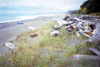
 Del Norte, neat little beach for lunch
Links to related images: Nearby. Proofs. Map.
Approximate location: 41.492618560791N / 124.074035644531W.
 Del Norte, neat beach looking N to Split Rock
Links to related images: Nearby. Proofs. Map.
Approximate location: 41.492618560791N / 124.074035644531W.
 Del Norte, green cliffs down to the water
Links to related images: Nearby. Proofs. Map.
Approximate location: 41.4907073974609N / 124.074546813965W.
 Johnson Creek, the border between the counties, viewed from offshore.
Links to related images: Nearby. Proofs. Map.
Approximate location: 41.4630470275879N / 124.06957244873W.
 Del Norte, unfamiliar Gold Bluff Beach
Links to related images: Nearby. Proofs. Map.
Approximate location: 41.4444618225098N / 124.075981140137W.
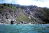
 Del Norte, campground at Gold Bluff Beach
Links to related images: Nearby. Proofs. Map.
Approximate location: 41.3840713500977N / 124.075859069824W.
 Del Norte, my landing spot on Gold Bluff Beach
Links to related images: Nearby. Proofs. Map.
Approximate location: 41.3462409973145N / 124.079849243164W.
 Del Norte, view north over Gold Bluff Camp
Links to related images: Nearby. Proofs. Map.
Approximate location: 41.346305847168N / 124.078819274902W.
 Del Norte, view south from gold bluff camp
Links to related images: Nearby. Proofs. Map.
Approximate location: 41.346305847168N / 124.078819274902W.
All text and images Copyright © 1999 by Mike Higgins / contact