Smith River to Oregon and Back. Monday August 9th 1999.
Click on the small image to see the full-sized one.
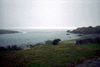 Del Norte, Smith River mouth.
Links to related images: Nearby. Proofs. Map.
Approximate location: 41.9471702575684N / 124.205505371094W.
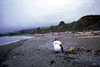 Del Norte, Fisherman across the border in Oregon
Links to related images: Nearby. Map.
Approximate location: 42.013973236084N / 124.232192993164W.
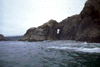
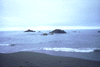 Del Norte, Rocks offshore of Oregon
Links to related images: Nearby. Map.
Approximate location: 42.013973236084N / 124.232192993164W.
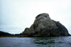
 Del Norte, Cone Rock
Links to related images: Nearby. Proofs. Map.
Approximate location: 41.9728927612305N / 124.218292236328W.
 Del Norte, Hunter Rock
Links to related images: Nearby. Proofs. Map.
Approximate location: 41.9563636779785N / 124.213401794434W.
 Del Norte, close up of offshore rock
Links to related images: Nearby. Proofs. Map.
Approximate location: 41.9563636779785N / 124.213401794434W.
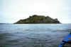 Del Norte, Prince Island
Links to related images: Nearby. Proofs. Map.
Approximate location: 41.9473609924316N / 124.212539672852W.
 Del Norte, Hole in Prince Island from shore side
Links to related images: Nearby. Proofs. Map.
Approximate location: 41.9514465332031N / 124.212882995605W.
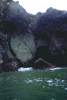
 Del Norte, Hole in Prince Island from ocean side
Links to related images: Nearby. Proofs. Map.
Approximate location: 41.9516372680664N / 124.216316223145W.
All text and images Copyright © 1999 by Mike Higgins / contact