Harvest Moon Paddle around Marin Island, October 6th 1998.
Click on the small image to see the full-sized one.
 Joan Weiner and Don Fleming ready for a moonlit padde around the Marin Islands
Links to related images: Nearby. Proofs. Map.
Approximate location: 37.9431838989258N / 122.51734161377W.
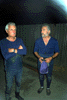 Don Fleming and Gino Thomas ready for a moonlit paddle around the Marin Islands.
Links to related images: Nearby. Proofs. Map.
Approximate location: 37.9431838989258N / 122.51734161377W.

 Starting out for a moonlit paddle around the Marin Islands.
Links to related images: Nearby. Proofs. Map.
Approximate location: 37.9429702758789N / 122.516578674316W.
 Paul starting out for a moonlit paddle around the Marin Islands.
Links to related images: Nearby. Proofs. Map.
Approximate location: 37.9429702758789N / 122.516578674316W.
 Starting out for a moonlit paddle around the Marin Islands.
Links to related images: Nearby. Proofs. Map.
Approximate location: 37.9429702758789N / 122.516578674316W.
 Don Fleming starting out for a moonlit paddle around the Marin Islands.
Links to related images: Nearby. Proofs. Map.
Approximate location: 37.9429702758789N / 122.516578674316W.
 Starting out for a moonlit paddle around the Marin Islands.
Links to related images: Nearby. Proofs. Map.
Approximate location: 37.9429702758789N / 122.516578674316W.
 Next to the pier on east Marin Island.
Links to related images: Nearby. Proofs. Map.
Approximate location: 37.9653205871582N / 122.467216491699W.
 Don Fleming poking the 'do not land here' sign on east Marin Island.
Links to related images: Nearby. Proofs. Map.
Approximate location: 37.9653205871582N / 122.467216491699W.
All text and images Copyright © 1998 by Mike Higgins / contact