Mendocino Campout, September 18th to 20th 1998.
Click on the small image to see the full-sized one.
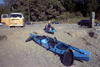 Maryly and I went abalone diving Friday afternoon at Van Damme on our way.
Links to related images: Nearby. Proofs. Map.
Approximate location: 39.3289985656738N / 123.825996398926W.
 Roger Lamb and I went Abalone diving Saturday morning.
Links to related images: Nearby. Proofs. Map.
Approximate location: 39.3289985656738N / 123.825996398926W.
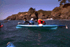 Maryly rescues Dave Kennar when he falls out of his Tsunami X15 on a washover.
Links to related images: Nearby. Proofs. Map.
Approximate location: 39.3289985656738N / 123.825996398926W.
 Maryly mixes fresh squozen Vodka screwdrivers.
Links to related images: Nearby. Proofs. Map.
Approximate location: 39.3289985656738N / 123.825996398926W.
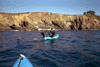
 Joe Petolino and Gerard borrow sit-on tops to go abalone diving.
Links to related images: Nearby. Proofs. Map.
Approximate location: 39.3289985656738N / 123.825996398926W.
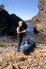
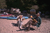 Maryly and I take it easy on the beach before preparing for dinner.
Links to related images: Nearby. Proofs. Map.
Approximate location: 39.3289985656738N / 123.825996398926W.
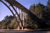
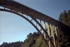
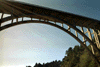 The beautiful Highway One bridge over Russian Gulch.
Links to related images: Nearby. Proofs. Map.
Approximate location: 39.3289985656738N / 123.825996398926W.
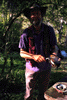

 I prepare my abalone for sashimi.
Links to related images: Nearby. Proofs. Map.
Approximate location: 39.3289985656738N / 123.825996398926W.
 Don 'ductape' Barch juggles knives and abalone pounders.
Links to related images: Nearby. Proofs. Map.
Approximate location: 39.3289985656738N / 123.825996398926W.
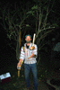
 Ken Kelton mesmerizes everyone with his story about the shark attack.
Links to related images: Nearby. Proofs. Map.
Approximate location: 39.3289985656738N / 123.825996398926W.

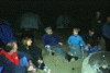
 BASKers at the campground at night.
Links to related images: Nearby. Proofs. Map.
Approximate location: 39.3289985656738N / 123.825996398926W.
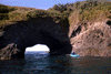

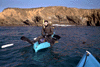
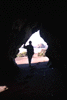
 Maryly follows me through a beautiful series of caves and coves.
Links to related images: Nearby. Proofs. Map.
Approximate location: 39.3289985656738N / 123.825996398926W.
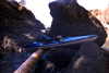 John 'Tsunami Ranger' Dixon paddles his boat out of the water.
Links to related images: Nearby. Proofs. Map.
Approximate location: 39.3289985656738N / 123.825996398926W.
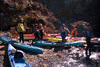 We are joined by a large group of BASKers for lunch on a rocky beach.
Links to related images: Nearby. Proofs. Map.
Approximate location: 39.3289985656738N / 123.825996398926W.


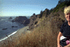 Maryly and I stop at Greenwood Cove on our way home.
Links to related images: Nearby. Proofs. Map.
Approximate location: 39.3289985656738N / 123.825996398926W.
All text and images Copyright © 1998 by Mike Higgins / contact