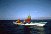
Baja, Monday April 13th 1998.
Click on the small image to see the full-sized one.
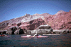
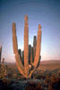
 Jean in front of basalt columns
Links to related images: Nearby. Proofs. Map.
Approximate location: 29.6583003997803N / 114.099998474121W.
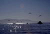
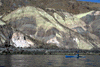
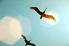 Everywhere we went we saw many pelicans.
Links to related images: Nearby. Proofs. Map.
Approximate location: 29.4582996368408N / 113.875W.
 Everywhere we went we saw many pelicans.
Links to related images: Nearby. Proofs. Map.
Approximate location: 29.4582996368408N / 113.875W.
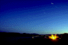
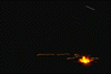
 Bob Stender look these long exposure pictures at night with a tripod.
Links to related images: Nearby. Proofs. Map.
Approximate location: 29.5666999816895N / 114W.
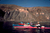
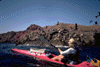
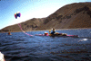
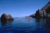 Kayakers paddling through rock garden
Links to related images: Nearby. Proofs. Map.
Approximate location: 29.4582996368408N / 113.875W.
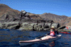
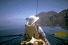 The back of Mari in the front seat of the double kayak
Links to related images: Nearby. Proofs. Map.
Approximate location: 29.4582996368408N / 113.875W.
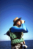 The salt crusted explorer looking ahead
Links to related images: Nearby. Proofs. Map.
Approximate location: 29.4582996368408N / 113.875W.
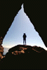
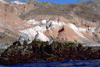
 We found a beautiful cave through a point where we could get out and walk
Links to related images: Nearby. Proofs. Map.
Approximate location: 29.4582996368408N / 113.875W.
 The intrepid kayak in the walk through cave. Baja
Links to related images: Nearby. Proofs. Map.
Approximate location: 29.4582996368408N / 113.875W.
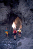 Bob Stender, Jeff and Mari Brandt in the walk through cave
Links to related images: Nearby. Proofs. Map.
Approximate location: 29.4582996368408N / 113.875W.
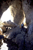 Joe Petolino in the walk through cave
Links to related images: Nearby. Proofs. Map.
Approximate location: 29.4582996368408N / 113.875W.
 Mary Marcia trying to reconstruct a sea turtle
Links to related images: Nearby. Proofs. Map.
Approximate location: 29.4582996368408N / 113.875W.
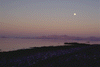
 The island in the background of these pictures is Guardian Angel Island.
As we
The island in the background of these pictures is Guardian Angel Island.
As we
Links to related images: Nearby. Proofs. Map.
Approximate location: 29.3666000366211N / 113.741996765137W.
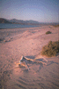
 Another campsite photographed by moonlight.
Links to related images: Nearby. Proofs. Map.
Approximate location: 29.4120006561279N / 113.779998779297W.
 The island in the background of these pictures is Guardian Angel Island.
Links to related images: Nearby. Proofs. Map.
Approximate location: 29.3666000366211N / 113.741996765137W.
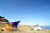
 Penny's pink boat in front of pink cliffs
Links to related images: Nearby. Proofs. Map.
Approximate location: 29.2917003631592N / 113.666999816895W.
 Pink cliffs above green water
Links to related images: Nearby. Proofs. Map.
Approximate location: 29.2917003631592N / 113.666999816895W.
 Pelicans in front of pink cliffs
Links to related images: Nearby. Proofs. Map.
Approximate location: 29.2917003631592N / 113.666999816895W.
 Jef and Mari's ouble kayak leaving pink cliffs
Links to related images: Nearby. Proofs. Map.
Approximate location: 29.2917003631592N / 113.666999816895W.
 The intrepid kayaker in front of multi-colored cliffs, Baja
Links to related images: Nearby. Proofs. Map.
Approximate location: 29.2917003631592N / 113.666999816895W.
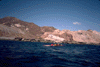
 Jean in front of rocky Baja shoreline
Links to related images: Nearby. Proofs. Map.
Approximate location: 29.2917003631592N / 113.666999816895W.
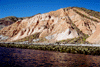
 Red hills reflecting in blue water
Links to related images: Nearby. Proofs. Map.
Approximate location: 29.2917003631592N / 113.666999816895W.
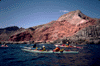
 Five kayaks all lined up
Links to related images: Nearby. Proofs. Map.
Approximate location: 29.2917003631592N / 113.666999816895W.
 Penny in front of pelican colony
Links to related images: Nearby. Proofs. Map.
Approximate location: 29.2917003631592N / 113.666999816895W.
 kayaks in front of pink cliffs
Links to related images: Nearby. Proofs. Map.
Approximate location: 29.2917003631592N / 113.666999816895W.
 The next section ofshoreline had beautiful painted cliffs dropping down
into th
The next section ofshoreline had beautiful painted cliffs dropping down
into th
Links to related images: Nearby. Proofs. Map.
Approximate location: 29.2917003631592N / 113.666999816895W.
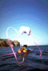
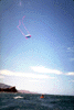 Bob Stender had meager luck using a large parafoil kite to pull his kayak.
Links to related images: Nearby. Proofs. Map.
Approximate location: 29.2917003631592N / 113.666999816895W.
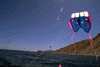
 Jeff and Mari Brandt had better luck with their sail.
Links to related images: Nearby. Proofs. Map.
Approximate location: 29.2917003631592N / 113.666999816895W.
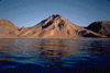
 The volcanic cone here is Isla Coronado on an island near the end of our
trip.
The volcanic cone here is Isla Coronado on an island near the end of our
trip.
Links to related images: Nearby. Proofs. Map.
Approximate location: 29.1916999816895N / 113.633003234863W.
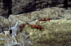 Sally lightfoot crabs
Links to related images: Nearby. Proofs. Map.
Approximate location: 29.2917003631592N / 113.666999816895W.
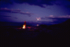
 Views by night of our campsite on Guadalupe Bay.
Links to related images: Nearby. Proofs. Map.
Approximate location: 29.1916999816895N / 113.633003234863W.
 The island in the background of these pictures is Guardian Angel Island.
Links to related images: Nearby. Proofs. Map.
Approximate location: 29.3666000366211N / 113.741996765137W.
 Views by night of our campsite on Guadalupe Bay.
Links to related images: Nearby. Proofs. Map.
Approximate location: 29.1916999816895N / 113.633003234863W.
 The little volcanic cone in this picture is Caleta Colorado De Guadalupe,
a 100
The little volcanic cone in this picture is Caleta Colorado De Guadalupe,
a 100
Links to related images: Nearby. Proofs. Map.
Approximate location: 29.1916999816895N / 113.633003234863W.
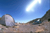
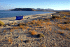 And views of the campsite by day.
Links to related images: Nearby. Proofs. Map.
Approximate location: 29.1916999816895N / 113.633003234863W.
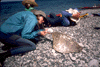
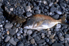 A spotted bay bass and a grunt caught for dinner
Links to related images: Nearby. Proofs. Map.
Approximate location: 29.5666999816895N / 114W.
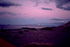
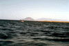
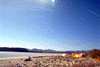
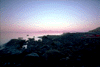 Isla Angel de la Guardia, will I go there some day?
Links to related images: Nearby. Proofs. Map.
Approximate location: 29.5666999816895N / 114W.
All text and images Copyright © 1998 by Mike Higgins / contact