Trans Bay Paddle, February 28th 1998.
Click on the small image to see the full-sized one.
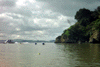 Rounding Yerba Bueno Island
Links to related images: Nearby. Proofs. Map.
Approximate location: 37.8076133728027N / 122.361083984375W.
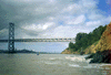 Bridge leaving West side of Yerba Bueno
Links to related images: Nearby. Proofs. Map.
Approximate location: 37.807071685791N / 122.363494873047W.
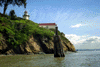 looking back at South point of Yerba Bueno
Links to related images: Nearby. Proofs. Map.
Approximate location: 37.8072738647461N / 122.364433288574W.
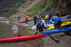 Landing on Yerba Bueno
Links to related images: Nearby. Proofs. Map.
Approximate location: 37.8078155517578N / 122.365463256836W.

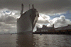 Big navy boat on SF waterfront
Links to related images: Nearby. Proofs. Map.
Approximate location: 37.781909942627N / 122.384521484375W.
All text and images Copyright © 1998 by Mike Higgins / contact