Drakes Estero, Berries Bay, July 12th 1997.
Click on the small image to see the full-sized one.
 Vew out to sea from inside Drakes Estero
Links to related images: Nearby. Proofs. Map.
Approximate location: 38.0589065551758N / 122.941390991211W.
 Cows at the end of Berries Bay
Links to related images: Nearby. Proofs. Map.
Approximate location: 38.0552558898926N / 122.960411071777W.
 View out Berries Bay into Drakes Estero
Links to related images: Nearby. Proofs. Map.
Approximate location: 38.0521812438965N / 122.957778930664W.
 View up a side valley from Berries Bay
Links to related images: Nearby. Proofs. Map.
Approximate location: 38.0492057800293N / 122.956497192383W.
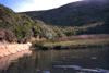
 The calm water inside Berries Bay
Links to related images: Nearby. Proofs. Map.
Approximate location: 38.0511665344238N / 122.957313537598W.
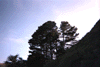
 Red tail hawk above the bluff in Drakes Estero
Links to related images: Nearby. Proofs. Map.
Approximate location: 38.0517082214355N / 122.935165405273W.
 The entrance to Berries Bay from Drakes Estero
Links to related images: Nearby. Proofs. Map.
Approximate location: 38.0430564880371N / 122.946365356445W.

 Small egrets in a tree on the shore of Drakes Estero
Links to related images: Nearby. Proofs. Map.
Approximate location: 38.0417709350586N / 122.94554901123W.
 White pelicans at the mouth of Drakes Estero
Links to related images: Nearby. Proofs. Map.
Approximate location: 38.0335922241211N / 122.936027526855W.
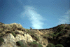 A stag ran up the cliff as I paddled by on Drakes Estero
Links to related images: Nearby. Proofs. Map.
Approximate location: 38.0518760681152N / 122.934867858887W.
 White egret on the shore of Drakes Estero
Links to related images: Nearby. Proofs. Map.
Approximate location: 38.0484962463379N / 122.936408996582W.
All text and images Copyright © 1997 by Mike Higgins / contact