Alder Creek Beach to Greenwood Cove, May 25th 1997.
Click on the small image to see the full-sized one.


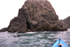
 White rock in Gunderson Cove
Links to related images: Nearby. Proofs. Map.
Approximate location: 39.092700958252N / 123.707000732422W.
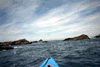
 Elk Cove distant
Links to related images: Nearby. Proofs. Map.
Approximate location: 39.092700958252N / 123.707000732422W.
 Distant coast near Elk Cove
Links to related images: Nearby. Proofs. Map.
Approximate location: 39.092700958252N / 123.707000732422W.
 Could this be the Tsunami Secret Cave?
Links to related images: Nearby. Proofs. Map.
Approximate location: 39.092700958252N / 123.707000732422W.
 Seal up close near Elk Cove
Links to related images: Nearby. Proofs. Map.
Approximate location: 39.092700958252N / 123.707000732422W.
 Narrow cave through Gunderson Rock
Links to related images: Nearby. Proofs. Map.
Approximate location: 39.092700958252N / 123.707000732422W.
 Big arch through Warf Rock
Links to related images: Nearby. Proofs. Map.
Approximate location: 39.092700958252N / 123.707000732422W.
 Arch in the south point of Greenwood Cove
Links to related images: Nearby. Proofs. Map.
Approximate location: 39.092700958252N / 123.707000732422W.
 Inside the Tsunami Secret Cave
Links to related images: Nearby. Proofs. Map.
Approximate location: 39.092700958252N / 123.707000732422W.
 Tsunami Secret Cave up close
Links to related images: Nearby. Proofs. Map.
Approximate location: 39.092700958252N / 123.707000732422W.
 Is this a puffin?
Links to related images: Nearby. Proofs. Map.
Approximate location: 39.092700958252N / 123.707000732422W.
 North end of Elk Cove
Links to related images: Nearby. Proofs. Map.
Approximate location: 39.092700958252N / 123.707000732422W.
 Inside big cave near Elk Cove
Links to related images: Nearby. Proofs. Map.
Approximate location: 39.092700958252N / 123.707000732422W.
 Gap through rocks near Elk Cove
Links to related images: Nearby. Proofs. Map.
Approximate location: 39.092700958252N / 123.707000732422W.
 Large arch near Elk Cove
Links to related images: Nearby. Proofs. Map.
Approximate location: 39.092700958252N / 123.707000732422W.
 dark cave near Elk Cove
Links to related images: Nearby. Proofs. Map.
Approximate location: 39.092700958252N / 123.707000732422W.
 Arch and nearshore channel near Elk Cove
Links to related images: Nearby. Proofs. Map.
Approximate location: 39.092700958252N / 123.707000732422W.
 Narrow crack near Greenwood Cove
Links to related images: Nearby. Proofs. Map.
Approximate location: 39.092700958252N / 123.707000732422W.
 Cave through Gunderson Rock
Links to related images: Nearby. Proofs. Map.
Approximate location: 39.092700958252N / 123.707000732422W.
 Small arches in Gunderson Rock
Links to related images: Nearby. Proofs. Map.
Approximate location: 39.092700958252N / 123.707000732422W.
 The beach on the north end of Elk Cove
Links to related images: Nearby. Proofs. Map.
Approximate location: 39.092700958252N / 123.707000732422W.
 Looking up Elk Creek from the beach at Elk Cove
Links to related images: Nearby. Proofs. Map.
Approximate location: 39.092700958252N / 123.707000732422W.

 The south beach at Elk Cove
Links to related images: Nearby. Proofs. Map.
Approximate location: 39.092700958252N / 123.707000732422W.
 North Elk Creek Beach
Links to related images: Nearby. Proofs. Map.
Approximate location: 39.092700958252N / 123.707000732422W.
 gap in rocks near Elk Cove
Links to related images: Nearby. Proofs. Map.
Approximate location: 39.092700958252N / 123.707000732422W.
 caves in shore near Elk Cove
Links to related images: Nearby. Proofs. Map.
Approximate location: 39.092700958252N / 123.707000732422W.
 Closeup of the rock in the middle of Elk Cove Rock
Links to related images: Nearby. Proofs. Map.
Approximate location: 39.092700958252N / 123.707000732422W.
 Elk Cove viewed from out at sea
Links to related images: Nearby. Proofs. Map.
Approximate location: 39.092700958252N / 123.707000732422W.
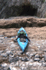
 Canoe campers on isolated Elk Cove Beach
Links to related images: Nearby. Proofs. Map.
Approximate location: 39.092700958252N / 123.707000732422W.
 Elk Cove viewed between offshore rocks.
Links to related images: Nearby. Proofs. Map.
Approximate location: 39.092700958252N / 123.707000732422W.
 I was surfed out of control to a landing on this beach near Elk Cove.
Links to related images: Nearby. Proofs. Map.
Approximate location: 39.092700958252N / 123.707000732422W.
 Gap in the offshore rocks near Elk Cove
Links to related images: Nearby. Proofs. Map.
Approximate location: 39.092700958252N / 123.707000732422W.
 Rough shoreline near Elk Cove.
Links to related images: Nearby. Proofs. Map.
Approximate location: 39.092700958252N / 123.707000732422W.
 Impassible arch near Elk Cove.
Links to related images: Nearby. Proofs. Map.
Approximate location: 39.092700958252N / 123.707000732422W.
 Kayakable gap behind rocks near Elk Cove.
Links to related images: Nearby. Proofs. Map.
Approximate location: 39.092700958252N / 123.707000732422W.

 Navigable arch near Elk Cove.
Links to related images: Nearby. Proofs. Map.
Approximate location: 39.092700958252N / 123.707000732422W.
 Looking south near Elk Cove.
Links to related images: Nearby. Proofs. Map.
Approximate location: 39.092700958252N / 123.707000732422W.
 Pocket beach near Elk Cove.
Links to related images: Nearby. Proofs. Map.
Approximate location: 39.0294990539551N / 123.700996398926W.
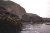
 Rocky point near Elk Cove.
Links to related images: Nearby. Proofs. Map.
Approximate location: 39.0294990539551N / 123.700996398926W.
 Small cove near Elk Cove.
Links to related images: Nearby. Proofs. Map.
Approximate location: 39.0294990539551N / 123.700996398926W.
 White Rock viewed from a distance.
Links to related images: Nearby. Proofs. Map.
Approximate location: 39.0294990539551N / 123.700996398926W.
 old acces road near Elk Cove.
Links to related images: Nearby. Proofs. Map.
Approximate location: 39.0294990539551N / 123.700996398926W.
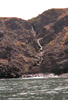 Waterfall near Elk Cove
Links to related images: Nearby. Proofs. Map.
Approximate location: 39.0294990539551N / 123.700996398926W.
 Seaweed berm north of Alder Creek.
Links to related images: Nearby. Proofs. Map.
Approximate location: 39.0294990539551N / 123.700996398926W.

 Crack in an offshore rock north of Alder Creek.
Links to related images: Nearby. Proofs. Map.
Approximate location: 39.0294990539551N / 123.700996398926W.
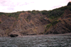
 Rocky point north of Alder Creek.
Links to related images: Nearby. Proofs. Map.
Approximate location: 39.0294990539551N / 123.700996398926W.
 Seals on a beach north of Alder Creek.
Links to related images: Nearby. Proofs. Map.
Approximate location: 39.0294990539551N / 123.700996398926W.
 Rocky point north of ALder Creek.
Links to related images: Nearby. Proofs. Map.
Approximate location: 39.0294990539551N / 123.700996398926W.
 Calm water close to shore north of Alder Creek.
Links to related images: Nearby. Proofs. Map.
Approximate location: 39.0294990539551N / 123.700996398926W.
All text and images Copyright © 1997 by Mike Higgins / contact