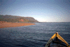
Kauai, Hanalei Bay to Kee Beach, Thursday April 17th 1997.
Click on the small image to see the full-sized one.
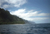
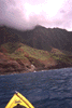
 The beach in front of the Lumahai River
Links to related images: Nearby. Proofs. Map.
Approximate location: 22.2040138244629N / 159.510848999023W.
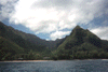
 the Lumahai River
Links to related images: Nearby. Proofs. Map.
Approximate location: 22.2062397003174N / 159.511444091797W.
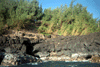
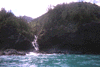
 Kolokolo Point where the Lumahai River empties into the Pacific.
Links to related images: Nearby. Proofs. Map.
Approximate location: 22.2180786132812N / 159.518569946289W.
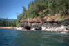
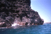
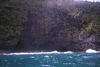
 Lava shoreline of Hanalei Harbor
Links to related images: Nearby. Proofs. Map.
Approximate location: 22.2093391418457N / 159.516326904297W.
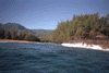
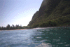
 Launching in the morning from Hanalei Harbor
Links to related images: Nearby. Proofs. Map.
Approximate location: 22.214900970459N / 159.497543334961W.
 The "Back Door" of the Double Door Cave is wider but not as deepas t
Links to related images: Nearby. Proofs. Map.
Approximate location: 22.198371887207N / 159.622253417969W.

 The "Back Door" of the Double Door Cave is wider but not as deep
as t
The "Back Door" of the Double Door Cave is wider but not as deep
as t
Links to related images: Nearby. Proofs. Map.
Approximate location: 22.198371887207N / 159.622253417969W.
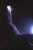
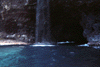
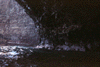
 Just inside the "Front Door" of the Double Door Cave is a lovely
wate
Just inside the "Front Door" of the Double Door Cave is a lovely
wate
Links to related images: Nearby. Proofs. Map.
Approximate location: 22.198371887207N / 159.622253417969W.
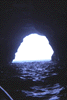
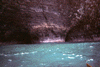
 Looking out the large sea cave
Links to related images: Nearby. Proofs. Map.
Approximate location: 22.1958293914795N / 159.627746582031W.

 Here are two (!) boats entering the cave, and one of them exiting out under
the
Here are two (!) boats entering the cave, and one of them exiting out under
the
Links to related images: Nearby. Proofs. Map.
Approximate location: 22.1916961669922N / 159.633239746094W.
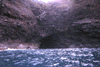
 This is the entrance to the "Worlds Second Largest Sea Cave".
Links to related images: Nearby. Proofs. Map.
Approximate location: 22.1916961669922N / 159.633239746094W.
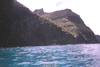
 I called this the "Big Dent" in the cliff, with several small caves
Links to related images: Nearby. Proofs. Map.
Approximate location: 22.1874046325684N / 159.638214111328W.
 The "Big Dent" in the cliff
Links to related images: Nearby. Proofs. Map.
Approximate location: 22.1874046325684N / 159.638214111328W.
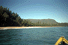
 Hanakapiai Beach, the first stop on the Na Pali Trail.
Links to related images: Nearby. Proofs. Map.
Approximate location: 22.2116432189941N / 159.599334716797W.
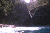
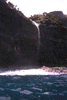
 A waterfall on the start of the Na Pali Coast
Links to related images: Nearby. Proofs. Map.
Approximate location: 22.2174434661865N / 159.590835571289W.
 Steep cliffs on the start of the Na Pali Coast
Links to related images: Nearby. Proofs. Map.
Approximate location: 22.2242774963379N / 159.583633422852W.
 Kee Beach, the end of the road before the Na Pali Coast area.
Links to related images: Nearby. Proofs. Map.
Approximate location: 22.2246742248535N / 159.580276489258W.
 Kee Beach, the end of the road before the Na Pali Coast area.
Links to related images: Nearby. Proofs. Map.
Approximate location: 22.2246742248535N / 159.580276489258W.
 Haena Beach, just before Kee Beach. The brown patch in the water is a sea
turtl
Haena Beach, just before Kee Beach. The brown patch in the water is a sea
turtl
Links to related images: Nearby. Proofs. Map.
Approximate location: 22.2233238220215N / 159.566207885742W.

 I saw this sea turtle in the water ahead of me. When it dove and traveledunder
Links to related images: Nearby. Proofs. Map.
Approximate location: 22.2285671234131N / 159.548004150391W.
 Haena Beach, just before Kee Beach. The brown patch in the water is a sea
turtl
Haena Beach, just before Kee Beach. The brown patch in the water is a sea
turtl
Links to related images: Nearby. Proofs. Map.
Approximate location: 22.2189521789551N / 159.538055419922W.
 Haena Beach, just before Kee Beach. The brown patch in the water is a seaturtl
Links to related images: Nearby. Proofs. Map.
Approximate location: 22.2189521789551N / 159.538055419922W.
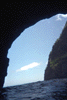
 An exposed volcanic dike creates a giant trangle of stone arching over
the wate
An exposed volcanic dike creates a giant trangle of stone arching over
the wate
Links to related images: Nearby. Proofs. Map.
Approximate location: 22.1918563842773N / 159.63444519043W.
All text and images Copyright © 1997 by Mike Higgins / contact