Kauai, Moloaa Bay to Kepuhi Point and back, Tuesday April 15th 1997.
Click on the small image to see the full-sized one.
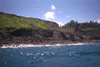 Traveling northwest around Mocolea Point
Links to related images: Nearby. Proofs. Map.
Approximate location: 22.223482131958N / 159.381500244141W.
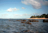
 The point at the north end of Sanders Beach
Links to related images: Nearby. Proofs. Map.
Approximate location: 22.1974182128906N / 159.330764770508W.
 Looking out from the inside of Sanders Reef
Links to related images: Nearby. Proofs. Map.
Approximate location: 22.2005176544189N / 159.331970214844W.
 Jamie washed up on Sanders Reef
Links to related images: Nearby. Proofs. Map.
Approximate location: 22.2005176544189N / 159.331970214844W.
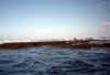
 Looking in from the outside of Sanders Reef
Links to related images: Nearby. Proofs. Map.
Approximate location: 22.2017097473145N / 159.33137512207W.
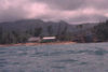 The houses at Moloaa Bay
Links to related images: Nearby. Proofs. Map.
Approximate location: 22.2157001495361N / 159.36799621582W.
All text and images Copyright © 1997 by Mike Higgins / contact