Pacifica State Beach to the Devil's Slide, October 10th 1996.
Click on the small image to see the full-sized one.
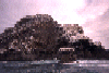
 San Pedro Island viewed from the south, far away and up close.
Links to related images: Nearby. Proofs. Map.
Approximate location: 37.578426361084N / 122.523735046387W.
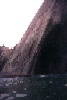 The island is made of rock layers tilted over 60 degrees.
Links to related images: Nearby. Proofs. Map.
Approximate location: 37.6006317138672N / 122.532791137695W.
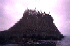 The island is separated from the mainland by a string of rocks.
Links to related images: Nearby. Proofs. Map.
Approximate location: 37.5970268249512N / 122.523010253906W.
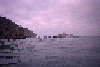 Approaching the island from the south.
Links to related images: Nearby. Proofs. Map.
Approximate location: 37.5995101928711N / 122.515968322754W.
All text and images Copyright © 1996 by Mike Higgins / contact