Horseshoe Bay to Schoomaker Beach, April 27th 1996.
Click on the small image to see the full-sized one.
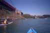
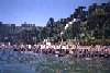
 BASKers landing in Horseshoe Cove
Links to related images: Nearby. Proofs. Map.
Approximate location: 37.8479995727539N / 122.464996337891W.
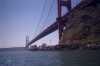
 BASKers paddling below the end of the Golden Gate Bridge
Links to related images: Nearby. Proofs. Map.
Approximate location: 37.8479995727539N / 122.464996337891W.
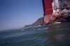 Turbulent water at the North Tower of the Golden Gate Bridge
Links to related images: Nearby. Proofs. Map.
Approximate location: 37.8479995727539N / 122.464996337891W.
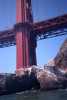
 The old building on Lime Point
Links to related images: Nearby. Proofs. Map.
Approximate location: 37.8479995727539N / 122.464996337891W.
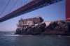
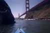
 Lime point and the North Tower of the Golden Gate Bridge
Links to related images: Nearby. Proofs. Map.
Approximate location: 37.8479995727539N / 122.464996337891W.
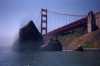
 The Golden Gate Bridge viewed from the north
Links to related images: Nearby. Proofs. Map.
Approximate location: 37.8479995727539N / 122.464996337891W.
 Needles Rock near the Golden Gate Bridge
Links to related images: Nearby. Proofs. Map.
Approximate location: 37.8479995727539N / 122.464996337891W.
 Golden Gate Bridge on-ramp behind Needles Rock
Links to related images: Nearby. Proofs. Map.
Approximate location: 37.8479995727539N / 122.464996337891W.
 Needles Rock, BASKers and the Golden Gate Bridge
Links to related images: Nearby. Proofs. Map.
Approximate location: 37.8479995727539N / 122.464996337891W.
 Marin side of the Golden Gate Bridge
Links to related images: Nearby. Proofs. Map.
Approximate location: 37.8479995727539N / 122.464996337891W.
 "Brown Beach" next to the sewage treatment plant
Links to related images: Nearby. Proofs. Map.
Approximate location: 37.8479995727539N / 122.464996337891W.
 Angel Island from the Sausalito area
Links to related images: Nearby. Proofs. Map.
Approximate location: 37.8479995727539N / 122.464996337891W.
 Houses at the shoreline in Saucalito
Links to related images: Nearby. Proofs. Map.
Approximate location: 37.8479995727539N / 122.464996337891W.
 Breakwater shoreline of Saucalito
Links to related images: Nearby. Proofs. Map.
Approximate location: 37.8479995727539N / 122.464996337891W.
 Houses at the shoreline in Saucalito
Links to related images: Nearby. Proofs. Map.
Approximate location: 37.8479995727539N / 122.464996337891W.

 Cormerants on the cliff south of Saucalito
Links to related images: Nearby. Proofs. Map.
Approximate location: 37.8479995727539N / 122.464996337891W.
All text and images Copyright © 1996 by Mike Higgins / contact