McClures Beach to Elephant Rock, October 27 1995.
Click on the small image to see the full-sized one.
 McClures Beach is rough and difficult to launch from.
Links to related images: Nearby. Proofs. Map.
Approximate location: 38.1833839416504N / 122.96898651123W.
 A cove just south of McClures Beach.
Links to related images: Nearby. Proofs. Map.
Approximate location: 38.1817474365234N / 122.967330932617W.


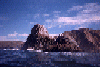
 Elephant Rock from many angles as I paddled around it.
Links to related images: Nearby. Proofs. Map.
Approximate location: 38.1791839599609N / 122.963272094727W.
 A cove just south of McClures Beach.
Links to related images: Nearby. Proofs. Map.
Approximate location: 38.1818161010742N / 122.966926574707W.


 Rough water around the rocks near McClures Beach.
Links to related images: Nearby. Proofs. Map.
Approximate location: 38.183723449707N / 122.968360900879W.
 Shoreline south of Elephant Rock.
Links to related images: Nearby. Proofs. Map.
Approximate location: 38.1888656616211N / 122.966796875W.
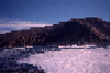
 View north towards Tomales Point and Bird Rock.
Links to related images: Nearby. Proofs. Map.
Approximate location: 38.1888656616211N / 122.966796875W.
 McClures Beach viewed from offshore.
Links to related images: Nearby. Proofs. Map.
Approximate location: 38.1888656616211N / 122.966796875W.
All text and images Copyright © 1995 by Mike Higgins / contact