![]()
![]()
![]()
![]()
![]()
![]()
Roger Lamb used to live somewhere near Martinez and knew the Carquinez waters of this neighborhood very well. He scheduled a BASK trip to paddle from Martinez down to the Carquinez Bridge and back and I was happy to come along. The trip was well planed with the ebbing tide helping us along as we launched and the flood tide scheduled to help push us home. The weather was a little threatening, but eight or nine paddlers showed up to try it out anyway. We started down the south shore of the Carquinez Straight with the intention of hugging the shore to stay out of the shipping lane.
After a while we paused at a beach with a backwater eddying back upstream. The people in sit inside kayaks wanted to get out and stretch their legs. In my sit-on-top I made them envious by just sliding forward and lying down on my boat with my head propped up on the seat-back. I opened my eyes from time to time to see if the cycling eddy had pulled me back into the rushing ebb current, but it never did. My boat seemed to pause at the edge of the current and made no progress until everyone else was ready to go. I had to sit back up and push my boat into the fast current again.
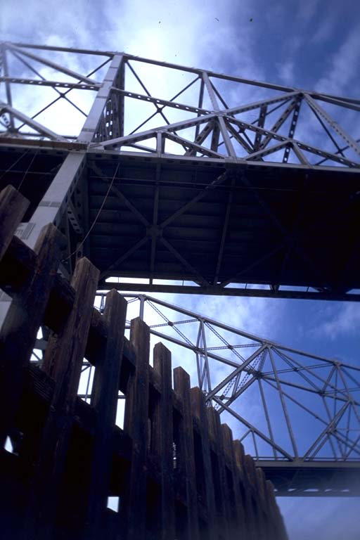
Roger lead us across the water to circumnavigate the central pylon of the Carquinez Bridge. He mentioned that it was possible to get inside the pylon, but had apparently never been inside himself before today. This artificial island holds up the center of the bridge and appears to be made of two diamonds of concrete held a meter or so above the water by a forest of concrete piers. The whole structure is surrounded by a fence of closely spaced wooden bars to prevent objects from being pulled underneath. Signs mounted all around warned us that trespassing and fishing off the pylon was forbidden and would be enforced by the California Highway Patrol. At one place, however, there was a gap in the fence and it looked possible to get inside. It was a little scary, since the strong ebb current could push your boat sideways into the posts or the surrounding fence. Pinned against a current like this I imagined that it would be easy to get rolled out of your boat and possibly even trapped underwater. Never-the-less we all went through the gap one at a time until the whole party was drifting inside.
The Carquinez bridge has two separate parallel spans, it having been expanded at one time by adding a second bridge to double the number of lanes. Apparently the concrete island was doubled at the same time and we found ourselves inside the first one with a low passage to another similar one. The center of each concrete island was hollow and we could sit up straight and look up between steel girders to the bottom of the roadbed. Ducking under the low space between the two spans we came up inside the upstream lanes. There was enough room to park dozens of kayaks in here, although the current tended to push us towards a low ceiling and a forest of posts. There were ladders on the inside walls that could allow us to climb up on top of the concrete if we felt like bringing down the wrath of the California Highway Patrol. We joked about how they were going to climb down from above to give us a ticket, but nobody tried out the ladders.
The hole we came in turned out to be the only way in or out, so we exited and continued around the pylon and back to the south shore to poke around in a little marina there. Then we headed north to have lunch at a little park with a gravel beach. The county is building a new fishing pier at this park and it does not have railings yet. So to protect the public they have fenced off the shoreline from the rest of the park. Of course this fence only trapped us in the "unsafe" shoreline and forced us to climb over it to get to the restrooms and back.
After lunch several kayakers paddled across to the north shore and the rest of us paddled back along the south shore. When we came to the last bend in the river, however, Roger lead us diagonally most of the way across to a pair of islands where he used to occasionally camp out of his kayak. This island is practically spitting distance from a county park with a fishing pier on the north shore. I portaged my boat across a shallow spot in the island and got out to go exploring, looking at the camping possibilities.
We had launched on a sunny morning with a slight wind blowing into our face as we headed downstream. The ebb current had helped pull us against this wind and as promised the flood current was helping us travel back "upstream". (Is it still called upstream when the tide is pushing water back uphill against the normal current?) The wind had turned and was coming from the south, across our bows. Wind from this direction generally means storms, and we saw dark clouds forming in the sky. However, these clouds were forming north of us and it seemed that the wind would push them away from us. Also, the sun was shining on is from the southwest making it difficult to believe that we could be in for bad weather. Apparently the wind from the south was some local phenomena because the dark clouds continued to build to our left and over our heads as we paddled diagonally across back to the Martinez marina. Thunder rumbled behind us and made us increase our paddling efforts. Our timing was excellent, however, and the rain did not start until we were all safely off the water and carrying our boats back to our cars.