BASK (the Bay Area Sea Kayakers) was having a meeting in Half Moon Bay that I wanted to attend. I figured that if I camped out after the meeting, I could go kayaking in a spot far down the coast south of San Francisco. Vial email I contacted the hosts of the meeting and got several suggestions for places to kayak and places to stay overnight. They suggested that camping on the beach would be too cold and damp this time of year because of the heavy fog. But the American Youth Hostel at the Montara Point Lighthouse was recommended. I stopped at this Hostel on the way south and reserved a bunk in the "Tool Room". I have never stayed in a Youth Hostel before. It turned out to be an interesting and fun experience. The Tool Room had bunk beds for 7 people, so I was essentially sleeping in a dormitory with 6 strangers. Access to the Tool Room was through the main room of the Fog Horn Building, which is reserved for a yoga class evenings between 6:30 and 8:30 PM. There was another dormitory room for women, and separate rooms for couples and larger families. Reservations for the couples rooms are highly recommended. There were shared bathrooms with showers and several communal kitchens, although one of these was reserved for a single large group. If you bring your own sheets or sleeping bag, you can save a dollar on the very reasonable rates. When you check out, you are given a task to do to help with the maintenance of the Hostel, like cleaning a bathroom or collecting litter from the yard.
The surroundings are spectacular. There are a few wooden chairs next to the lighthouse where you can look down onto the short cliffs to the ocean. Just offshore is a network of barnacle-covered rocks. At low tide you can go tide pooling between these rocks, according to signs I saw. Just north of the Fog Horn Building is a hot tub and a trail down to a little sandy beach. I walked down to the beach and watched the waves for a while. It would be relatively easy to launch a kayak through the surf here. Unfortunately, they lock the gates through the middle of the day, and I would be unable to leave if I launched from here. Perhaps some other day I will come and stay two nights, kayaking the whole day through in between. I sat under the lighthouse working on my laptop for a few hours before my meeting, then sat under it again without the laptop after the meeting. In the thin fog after dark, the lighthouse cast a spinning web of beams out over me and the ocean. If you were out at sea, the multiple beams would flash at you every three seconds.
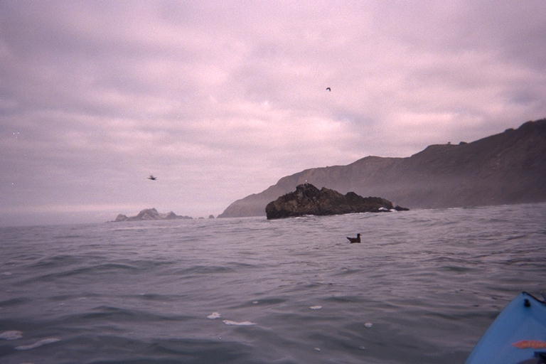
In the morning, I drove north looking for a public beach I had stopped at on the way down, but was unable to find it. Instead I ran into the end of rush-hour traffic heading into San Francisco out of the town of Pacifica. When this happened, I turned around at the next corner and went back to Pacifica State Beach. This is a popular beach for surfers, but it looked like the south end had mild waves for an easy surf launch. The parking lot had a sign in it that said "No personal water craft allowed on this beach". I took this to mean no powered water craft, like jet ski's and zodiacs. There were a few people surfing in kayaks, so I assume kayaks are not included in the prohibition. I slid my kayak south past the last surfer, launched over the waves and headed farther south.
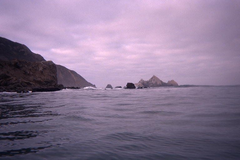
I was heading towards a large rocky island that can be seen from kilometers up and down the coast from highway one. I thought it would be just past the first point south of the beach, but when I came around that point, I found a small cove before the main point and the island. This cove is called Shelter Cove on the map, another one of those names used over and over again on the coast. Like Seal Rock and Pebble Beach. This is the Devils Slide area, where the cliffs are constantly eroding and sliding into the ocean. Incredibly, highway one used to run along the shore here until only a few years ago. The cliffs were always eroding out from under the road or dumping tones of rock on top of it, so they finally built a temporary bypass through a notch in the hill behind the cliffs. Now they are arguing about replacing the temporary bypass with a permanent one farther inland, or drilling a tunnel under the middle. From the water, I can still see a few pieces of the road hanging on the side of the cliffs. Less than half of the road remains after such a short time even in human terms.
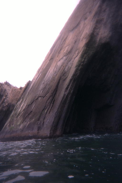
After Shelter Cove is San Pedro Point. At the tip of this point is an island that is made of huge slabs of sedimentary rock tilted at least 60 degrees from the level they were created. The slabs of rock lean to the south, so I approached broad flat surfaces tilting up and away from me. This continued under the water and it was deep and calm on the north side. But on the south side, the slabs have crumbed off and piled up to make the water shallow. Even though the waves were coming from the usual northwest direction, the shallow water on the south side of the island caused the waves to refract around and break onto the south side when the same waves did not break on the north side. Between the point and the island is a row of rocks, all part of the same tilted formation, and the waves were breaking between the rocks. The breakers were just about moving in the opposite direction from the swells that created them. As a result, I could not paddle between the shore and the first rock. I explored out to the tip of the island and back, and chose a gap between two rocks to make my passage. I waited at the end of the channel for a few large waves to break and wash past, and then charged through with no problems for me. Unfortunately, my arrival was a problem for a dozen harbor seals. They had been hauled out on rocks on the south side of the island, but charged into the water when I appeared out of nowhere. Sorry guys.
I continued traveling south past the bulk of the Devils Slide area. From the last point before the Edun Cove I could see the Montara Point Lighthouse flashing every three seconds at me, three kilometers away. I turned back since I have a long drive ahead of me and some work to get to. I'll save this stretch of coastline for that two night trip in the Hostel one day. I headed straight back for the outermost tip of the tilted slab island. From there I explored the south side of the island back to shore. Right near shore was a vent that spouted water ten meters up into the air when the waves were right. It didn't spout on the largest waves, but waited for some combination of two waves, then spouted seconds after you would think it should. It was created by a long slot carved in the rock where a softer layer of rock had eroded from between two harder ones in the tilted terrain near water level.
I went back to the gap between the two rocks that I had passed through recently. The tide was rising, and I had hoped the water would be deeper by now. But I really had not been gone long enough. I waited for a large set to go through, then followed a smaller wave in. Too late to catch that little wave when it broke, I was a little disappointed until a larger one caught up with the kayak. It gave us a shove that pushed the kayak out into open sea on the other side of the rocks.
I cut straight back point-to-point and back to Pacifica State Beach. I stayed far enough south to avoid running into surfers, and far enough north to avoid the fishermen. But I failed to notice that the fishermen had a picket fence of poles up and down the beach, and I almost surfed into a fishing line. My timing was good, for a surf chicken kayaker, and I had an easy and calm ride back onto the beach.